more stats
2,339 ft
Distance
102 ft
Climb
-41 ft
Descent
00:04:52
Avg time
61 ft
Altitude change
349 ft
Altitude min
418 ft
Altitude max
349 ft
Altitude start
411 ft
Altitude end
2.623%
Grade
-13.618%
Grade max
30.642%
Grade min
1,186 ft
Distance climb
501 ft
Distance down
389 ft
Distance flat
00:04:52
Avg time

CCTV Details

  • Activities
    • Mountain Bike
    • E-Bike
  • Riding Area
  • AKA
    Vertical Limit
  • Difficulty Rating
  • Voted Difficulty
    Blue (1 vote)
  • Local Popularity
    95 in Mountain Biking [+]
    • 95 in E-Biking
  • Global Ranking
    #37900 in Mountain Biking [+]
    • #15195 in E-Biking
  • Trail Type
    Singletrack
  • Bike Type
    XC
  • Direction
    Both Directions
  • Climb Difficulty
    Blue
  • Physical Rating
    Moderate
  • Trail Visibility
    Always easy to follow
  • eBike Allowed
    Yes up to Class 1
  • Land Owner
    Queensland Parks and Wildlife Service
  • OSM Way

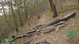
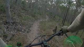
Starts part way in on Mongrells (3 Hills end) and joins the fire road opposite Top Drop and Pipeline Express This trail is a traverse with not much that climbing. It needs some TLC as the trail build was unsanctioned and it's final works were stopped Difficulty rating due to fall height exposure on low-side of trail.

This trail is unsanctioned.

Traditionally Indigenous Territory

Recent Activity on Trail

Past Week
  • 7 rides
  • 14.9 km average
6 Months
  • 86 rides
  • 16.7 km avg distance
All
  • 688 rides
  • Last: Jun 30, 2026
c1c2c3c4
January
February
March
April
May
June
July
August
September
October
November
December
Status:
on Jun 14, 2026
Ideal
Avg: 4.08 (5 votes)
Your vote: 0

view (4,133)
close
3D
Trail Conditions
  • Unknown
  • Snow Groomed
  • Snow Packed
  • Snow Covered
  • Snow Cover Partial
  • Freeze/thaw Cycle
  • Icy
  • Prevalent Mud
  • Wet
  • Variable
  • Ideal
  • Dry
  • Very Dry
Trail Flow (Ridden Direction)
Trailforks scans users ridelogs to determine the most popular direction each trail is ridden. A good flowing trail network will have most trails flowing in a single direction according to their intension.
The colour categories are based on what percentage of riders are riding a trail in its intended direction.
  • > 96%
  • > 90%
  • > 80%
  • > 70%
  • > 50%
  • < 50%
  • bi-directional trail
  • no data
Trail Last Ridden
Trailforks scans ridelogs to determine the last time a trail was ridden.
  • < 2 days
  • < 1 week
  • < 2 weeks
  • < 1 month
  • < 6 months
  • > 6 months
Trail Ridden Direction
The intended direction a trail should be ridden.
  • Downhill Only
  • Downhill Primary
  • Both Directions
  • Uphill Primary
  • Uphill Only
  • One Direction
Contribute Details
Colors indicate trail is missing specified detail.
  • Description
  • Photos
  • Description & Photos
  • Videos
Trail Popularity ?
Trailforks scans ridelogs to determine which trails are ridden the most in the last 9 months. Trails are compared with nearby trails in the same city region with a possible 25 colour shades. Think of this as a heatmap, more rides = more kinetic energy = warmer colors.
  • most popular
  • popular
  • less popular
  • not popular
ATV/ORV/OHV Filter
Max Vehicle Width
inches
US Cell Coverage
Legend
cell carrier legend

Radar Time
Activity Recordings
Trailforks uses anonymized public activity data. ?
Activity Recordings
Trailforks uses anonymized public activity data. ?
Personal Heatmap
Activity Types
all / none
Options
2
Date range month
Winter Trails
Warning A routing network for winter maps does not exist. Selecting trails using the winter trails layer has been disabled.
Missing Trails
Most Popular
Least Popular
Trails are colored based on popularity. The more popular a trail is, the more red. Less popular trails trend towards green.
Jump Magnitude Heatmap
Heatmap of where riders jump on trails. Zoom in to see individual jumps, click circles to view jump details.
BC Backroad Status

Service Road Atlas is a free to use, community-driven service for viewing and creating reports on the numerous back-country service roads around B.C. and Alberta.

map legend
Slope Aspect
Direction the slope faces
Flat N NE E SE S SW W NW
Trails Deemphasized
Trails are shown in grey.
disable
Only show trails with no bike usage.
Enable
Suggested Layers
Based on selected activity type

    Save the current map location and zoom level as your default home location whenever this page is loaded.

    Save
        Directions to cctv trailhead (-27.973980, 153.329980)

        Photos

        3 more »
        39 |
        Jan 25, 2021 @ 1:40pm
        Jan 25, 2021
        48 |
        Apr 12, 2020 @ 1:23pm
        Apr 12, 2020
        47 |
        Mar 15, 2020 @ 1:26am
        Mar 15, 2020

        Videos

        2 more »
        CCTV (Eastbound) - Nerang National Park -...
        3:11 | 542 | Aug 10, 2020 , Gold Coast
        CCTV (West Bound) - Nerang National Park -...
        4:41 | 292 | Jul 27, 2020 , Gold Coast

        Routes with this trail

        3.0 7 miles 756 ft 21
        Causarina -> -> -> -> -> -> -> -> Causarina
        26 miles 3,163 ft 19
        Zaak's 40k solo route. Covers many of the best Nerang trails with a bit of climbing and plenty of rocky flow.
        26 miles 3,163 ft 55
        Zaak's 40k solo route. Covers many of the best Nerang trails with a bit of climbing and plenty of rocky flow.

        1 Review & Comments


        We hope you've been enjoying Trailforks!

        Create a FREE account to view trail comments and much more.

        • #143369 - 1,770 views

        Frequently Asked Questions About CCTV

        Where is CCTV located?
        CCTV is located in Nerang National Park, Gold Coast, Australia. It is part of the Nerang National Park trail network. The trailhead is located at coordinates -27.97398, 153.32998.
        How hard is CCTV?
        CCTV is rated as Black Diamond difficulty. The physical rating is Moderate. The average grade is 2.623%. The climb difficulty is rated Blue.
        What is the elevation gain for CCTV?
        CCTV has 31 m of elevation gain. The trail has 13 m of elevation descent. The elevation ranges from 107 m to 128 m.
        Is CCTV a point to point trail?
        CCTV is not a point to point trail. The direction is Both Directions. The trail type is singletrack.

        Hit the Trail

        Open in App

        Get this trail on your phone instantly.
        open trail in app

        Download Trail

        Save to wishlist, Garmin & download.
        save the trail

        Find Related Routes

        Find routes and users activities that include this trail.
        find routes for this trail

        You must enter a description before submitting.