more stats
3.7 miles
Distance
726 ft
Climb
-523 ft
Descent
00:40:30
Avg time
203 ft
Altitude change
4,720 ft
Altitude min
5,249 ft
Altitude max
4,720 ft
Altitude start
4,923 ft
Altitude end
1.039%
Grade
-20.935%
Grade max
20.652%
Grade min
2 miles
Distance climb
1 mile
Distance down
1,348 ft
Distance flat
00:40:30
Avg time

Centennial Loop Details

  • Activities
    • Mountain Bike
    • Hike
    • Trail Running
  • Riding Area
    Centennial Park
    Carson City, Nevada
  • Difficulty Rating
  • Local Popularity
    65 in Mountain Biking [+]
    • 65 in Trail Running
    • 5 in Hiking
  • Global Ranking
    #108703 in Mountain Biking [+]
    • #98816 in Trail Running
    • #131301 in Hiking
  • Trail Type
    Singletrack
  • Bike Type
    AM, XC
  • Direction
    Both Directions
    Popular In Reverse
  • Climb Difficulty
    Blue
  • Physical Rating
    Moderate
  • Dogs Allowed
    Yes

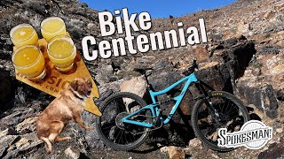
The first climb up this lollipop loop, while not steep, is a bit on the rocky side but is rideable. The loop itself is usually ridden in the counterclockwise direction​. It is mostly singletrack but does have a few short sections of doubletrack road. There is no trail signage and, depending on use, portions of the trail can sometimes be overgrown or covered with tumbleweeds. The majority of the trail is on BLM land; there is often a herd of wild horses in the area, use caution when approaching them and if needed modify your route.

This trail is unsanctioned.

Trail Supporters
  • BLM
    BLM
    Land Manager
Traditionally Indigenous Territory

Recent Activity on Trail

Past Week
  • 0 rides
  •  
6 Months
  • 5 rides
  • 5 miles avg distance
All
  • 37 rides
  • Last: May 14, 2026
c1c2c3c4
January
February
March
April
May
June
July
August
September
October
November
December
update trails status or condition

Centennial Loop Trail Reports

statusdatedescription
Jan 29, 2022 @ 8:18pm
Jan 29, 2022
clear and dry
Mar 24, 2021 @ 1:16pm
Mar 24, 2021
Feb 28, 2021 @ 12:49pm
Feb 28, 2021
Saw 2 horses on Pale Rider. They ignored me. Today the trails are dry and good to ride. There's a lot of loose gravel and lots of small soose...
Feb 8, 2021 @ 10:52pm
Feb 8, 2021
Apr 30, 2018 @ 3:21pm
Apr 30, 2018
Dry, alot of loose gravel and rocks on single track. Limited mustang in the area, they have moved up the mountainside apparently. :)
more »
Status:
on Jan 29, 2022
Dry
Avg: 3.65 (3 votes)
Your vote: 0

view (185)
close
3D
Trail Conditions
  • Unknown
  • Snow Groomed
  • Snow Packed
  • Snow Covered
  • Snow Cover Partial
  • Freeze/thaw Cycle
  • Icy
  • Prevalent Mud
  • Wet
  • Variable
  • Ideal
  • Dry
  • Very Dry
Trail Flow (Ridden Direction)
Trailforks scans users ridelogs to determine the most popular direction each trail is ridden. A good flowing trail network will have most trails flowing in a single direction according to their intension.
The colour categories are based on what percentage of riders are riding a trail in its intended direction.
  • > 96%
  • > 90%
  • > 80%
  • > 70%
  • > 50%
  • < 50%
  • bi-directional trail
  • no data
Trail Last Ridden
Trailforks scans ridelogs to determine the last time a trail was ridden.
  • < 2 days
  • < 1 week
  • < 2 weeks
  • < 1 month
  • < 6 months
  • > 6 months
Trail Ridden Direction
The intended direction a trail should be ridden.
  • Downhill Only
  • Downhill Primary
  • Both Directions
  • Uphill Primary
  • Uphill Only
  • One Direction
Contribute Details
Colors indicate trail is missing specified detail.
  • Description
  • Photos
  • Description & Photos
  • Videos
Trail Popularity ?
Trailforks scans ridelogs to determine which trails are ridden the most in the last 9 months. Trails are compared with nearby trails in the same city region with a possible 25 colour shades. Think of this as a heatmap, more rides = more kinetic energy = warmer colors.
  • most popular
  • popular
  • less popular
  • not popular
ATV/ORV/OHV Filter
Max Vehicle Width
inches
US Cell Coverage
Legend
cell carrier legend

Radar Time
Activity Recordings
Trailforks uses anonymized public activity data. ?
Activity Recordings
Trailforks uses anonymized public activity data. ?
Personal Heatmap
Activity Types
all / none
Options
2
Date range month
Winter Trails
Warning A routing network for winter maps does not exist. Selecting trails using the winter trails layer has been disabled.
Missing Trails
Most Popular
Least Popular
Trails are colored based on popularity. The more popular a trail is, the more red. Less popular trails trend towards green.
Jump Magnitude Heatmap
Heatmap of where riders jump on trails. Zoom in to see individual jumps, click circles to view jump details.
BC Backroad Status

Service Road Atlas is a free to use, community-driven service for viewing and creating reports on the numerous back-country service roads around B.C. and Alberta.

map legend
Slope Aspect
Direction the slope faces
Flat N NE E SE S SW W NW
Trails Deemphasized
Trails are shown in grey.
disable
Only show trails with no bike usage.
Enable
Suggested Layers
Based on selected activity type

    Save the current map location and zoom level as your default home location whenever this page is loaded.

    Save
        Directions to centennial-loop trailhead (39.200280, -119.706680)

        Photos

        9 more »
        133 |
        Feb 1, 2022 @ 6:23pm
        Feb 1, 2022
        153 |
        Mar 14, 2019 @ 8:10pm
        Mar 14, 2019
        162 |
        Mar 14, 2019 @ 8:10pm
        Mar 14, 2019
        148 |
        Mar 14, 2019 @ 8:10pm
        Mar 14, 2019

        Videos

        2 more »
        BikeCentennial!
        16:53 | 218 | Feb 28, 2022 , Carson City

        Reviews / Comments

        No reviews yet, be the first to write a review or ask a question.
        Use trail reports to comment on trail conditions.


        We hope you've been enjoying Trailforks!

        Create a FREE account to view trail comments and much more.

        • #87564 - 3,574 views

        Frequently Asked Questions About Centennial Loop

        Where is Centennial Loop located?
        Centennial Loop is located in Centennial Park, Carson City, Nevada, United States. It is part of the Centennial Park trail network. The trailhead is located at coordinates 39.20028, -119.70668.
        How hard is Centennial Loop?
        Centennial Loop is rated as Blue difficulty. The physical rating is Moderate. The average grade is 1.039%. The climb difficulty is rated Blue.
        What is the elevation gain for Centennial Loop?
        Centennial Loop has 726 ft of elevation gain. The trail has 523 ft of elevation descent. The elevation ranges from 4,720 ft to 5,249 ft.
        Is Centennial Loop a point to point trail?
        Centennial Loop is not a point to point trail. The direction is Both Directions. The trail type is singletrack.

        Hit the Trail

        Open in App

        Get this trail on your phone instantly.
        open trail in app

        Download Trail

        Save to wishlist, Garmin & download.
        save the trail

        Find Related Routes

        Find routes and users activities that include this trail.
        find routes for this trail

        You must enter a description before submitting.