more stats
1,299 ft
Distance
4 ft
Climb
-105 ft
Descent
00:02:01
Avg time
-104 ft
Altitude change
563 ft
Altitude min
667 ft
Altitude max
667 ft
Altitude start
564 ft
Altitude end
-8%
Grade
-19.5%
Grade max
6.1%
Grade min
108 ft
Distance climb
1,129 ft
Distance down
62 ft
Distance flat
00:02:01
Avg time

CHAINSAW (Upper) Details

  • Activities
    • Mountain Bike
    • E-Bike
  • Riding Area
    Bear Mountain
    Victoria, British Columbia
  • Difficulty Rating
  • Voted Difficulty
    Double Black Diamond (4 votes)
  • Local Popularity
    35 in Mountain Biking [+]
    • 45 in E-Biking
  • Global Ranking
    #85439 in Mountain Biking [+]
    • #69259 in E-Biking
  • Trail Type
    Singletrack
  • Bike Type
    DH, AM
  • Direction
    Downhill Only
    Popular Direction Shown
  • Climb Difficulty
    Blue
  • Physical Rating
    Moderate
  • Trail Visibility
    Always easy to follow
  • Dogs Allowed
    Yes
  • eBike Allowed
  • TTFs on Trail
    Berm, Drop, Jump, Gap Jump, Rock Face, Rock Garden
  • Land Owner
    Bear Mt Resorts

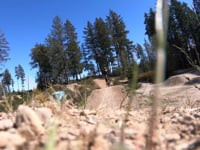
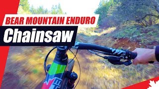
Chainsaw is a fun downhill style trail that starts off with a rock roll, berm jumps, and a set of large tabletop jumps (around 20-30 feet). It is recommended to do a slow run through the line to check out all the features before trying them. After the jump section there is a traverse with some rollers, rock gardens, and some smaller jumps. Overall, an awesome trail that would be best on a trail bike to downhill bike. One of the coolest trails on the island and it would best be enjoyed by an advanced rider. There is really nothing else like it in Victoria. Originally built by the Southern Vancouver Island nature Trails Society with the bottom portion using Dean Tenants practice DH trail. Then it was retrofitted by Jordie Lund with large jumps.

Disclaimer

Upper Chainsaw is very different from Lower Chainsaw. If you do not want to enter double black dh gnar then exit off the trail on either Blue Buck Extension or LittleBones.

Recent Activity on Trail

Past Week
  • 0 rides
  •  
6 Months
  • 11 rides
  • 12 miles avg distance
All
  • 225 rides
  • Last: Jun 11, 2026
c1c2c3c4
January
February
March
April
May
June
July
August
September
October
November
December
update trails status or condition

CHAINSAW (Upper) Trail Reports

statusdatedescription
Jun 3, 2026 @ 9:27am (America/Vancouver)
Jun 3, 2026
Fully rideable but the bushes and grass are encroaching. Brushing work has started...
May 3, 2026 @ 10:51am (America/Vancouver)
May 3, 2026
Apr 11, 2026 @ 7:54am (America/Vancouver)
Apr 11, 2026
Starting to get a bit grassy but running good
Jan 1, 2026 @ 3:25pm (America/Vancouver)
Jan 1, 2026
In good shape
Nov 30, 2025 @ 12:55am (America/Vancouver)
Nov 30, 2025
Mint.
more »
Status:
on Jun 3, 2026
Dry
Avg: 4.45 (16 votes)
Your vote: 0

view (1,580)
close
3D
Trail Conditions
  • Unknown
  • Snow Groomed
  • Snow Packed
  • Snow Covered
  • Snow Cover Partial
  • Freeze/thaw Cycle
  • Icy
  • Prevalent Mud
  • Wet
  • Variable
  • Ideal
  • Dry
  • Very Dry
Trail Flow (Ridden Direction)
Trailforks scans users ridelogs to determine the most popular direction each trail is ridden. A good flowing trail network will have most trails flowing in a single direction according to their intension.
The colour categories are based on what percentage of riders are riding a trail in its intended direction.
  • > 96%
  • > 90%
  • > 80%
  • > 70%
  • > 50%
  • < 50%
  • bi-directional trail
  • no data
Trail Last Ridden
Trailforks scans ridelogs to determine the last time a trail was ridden.
  • < 2 days
  • < 1 week
  • < 2 weeks
  • < 1 month
  • < 6 months
  • > 6 months
Trail Ridden Direction
The intended direction a trail should be ridden.
  • Downhill Only
  • Downhill Primary
  • Both Directions
  • Uphill Primary
  • Uphill Only
  • One Direction
Contribute Details
Colors indicate trail is missing specified detail.
  • Description
  • Photos
  • Description & Photos
  • Videos
Trail Popularity ?
Trailforks scans ridelogs to determine which trails are ridden the most in the last 9 months. Trails are compared with nearby trails in the same city region with a possible 25 colour shades. Think of this as a heatmap, more rides = more kinetic energy = warmer colors.
  • most popular
  • popular
  • less popular
  • not popular
ATV/ORV/OHV Filter
Max Vehicle Width
inches
US Cell Coverage
Legend
cell carrier legend

Radar Time
Activity Recordings
Trailforks uses anonymized public activity data. ?
Activity Recordings
Trailforks uses anonymized public activity data. ?
Personal Heatmap
Activity Types
all / none
Options
2
Date range month
Winter Trails
Warning A routing network for winter maps does not exist. Selecting trails using the winter trails layer has been disabled.
Missing Trails
Most Popular
Least Popular
Trails are colored based on popularity. The more popular a trail is, the more red. Less popular trails trend towards green.
Jump Magnitude Heatmap
Heatmap of where riders jump on trails. Zoom in to see individual jumps, click circles to view jump details.
BC Backroad Status

Service Road Atlas is a free to use, community-driven service for viewing and creating reports on the numerous back-country service roads around B.C. and Alberta.

map legend
Slope Aspect
Direction the slope faces
Flat N NE E SE S SW W NW
Trails Deemphasized
Trails are shown in grey.
disable
Only show trails with no bike usage.
Enable
Suggested Layers
Based on selected activity type

    Save the current map location and zoom level as your default home location whenever this page is loaded.

    Save
        Directions to chainsaw-upper trailhead (48.475180, -123.525090)

        Photos

        24 more »
        2,359 |
        May 1, 2017 @ 12:19pm
        May 1, 2017
        173 |
        Nov 3, 2020 @ 10:18am
        Nov 3, 2020
        172 |
        Nov 3, 2020 @ 10:18am
        Nov 3, 2020
        302 |
        Oct 6, 2020 @ 10:53am
        Oct 6, 2020

        Videos

        13 more »
        Bear Mountain Chainsaw Massacre
        5:22 | 1297 | Apr 27, 2020 , Victoria
        2019 Bear Mountain Enduro Chainsaw Trail
        2:56 | 1654 | Apr 2, 2019 , Victoria
        VR TRAIL BLAZE - REARVIEW Mirror - Skirt Ridge
        5:01 | 508 | Jan 8, 2019 , Victoria
        VR TRAIL BLAZE - TRAIL: Skirt Ridge - Langford BC
        4:48 | 980 | Jan 6, 2019 , Victoria

        Routes with this trail

        1.0 23 miles 3,373 ft 98 Loop
        Big day hitting Mt Work to Hey Daryl (not on Trailforks), over to Scafe Mtn and down Tom's then a loop on...

        6 Reviews & Comments


        We hope you've been enjoying Trailforks!

        Create a FREE account to view trail comments and much more.

        • By vinko & contributors
        • #77955 - 10,212 views

        Frequently Asked Questions About CHAINSAW (Upper)

        Where is CHAINSAW (Upper) located?
        CHAINSAW (Upper) is located in Bear Mountain, Victoria, British Columbia, Canada. It is part of the Bear Mountain trail network. The trailhead is located at coordinates 48.47518, -123.52509.
        How hard is CHAINSAW (Upper)?
        CHAINSAW (Upper) is rated as Double Black Diamond difficulty. The physical rating is Moderate. The average grade is 8%. The climb difficulty is rated Blue.
        What is the elevation gain for CHAINSAW (Upper)?
        CHAINSAW (Upper) has 4 ft of elevation gain. The trail has 105 ft of elevation descent. The elevation ranges from 563 ft to 667 ft.
        Is CHAINSAW (Upper) a point to point trail?
        Yes, CHAINSAW (Upper) is a point to point trail. The direction is Downhill Only. The trail type is singletrack.

        Hit the Trail

        Open in App

        Get this trail on your phone instantly.
        open trail in app

        Download Trail

        Save to wishlist, Garmin & download.
        save the trail

        Find Related Routes

        Find routes and users activities that include this trail.
        find routes for this trail

        You must enter a description before submitting.