

more stats
1.1 miles
Distance
163 ft
Climb
-5 ft
Descent
00:09:43
Avg time
158 ft
Altitude change
2,839 ft
Altitude min
2,997 ft
Altitude max
2,839 ft
Altitude start
2,997 ft
Altitude end
2.686%
Grade
-2.453%
Grade max
8.632%
Grade min
4,371 ft
Distance climb
263 ft
Distance down
1,231 ft
Distance flat
00:09:43
Avg time

Cholla Mtn. Loop Details

  • Activities
    • Mountain Bike
    • Horse
    • Hike
    • Trail Running
  • Riding Area
    Brown's Ranch
    Scottsdale, Arizona
  • Difficulty Rating
  • Local Popularity
    95 in Mountain Biking heatmap [+]
    • 75 in Trail Running
    • 90 in Hiking
    • 95 in Horseback
  • Global Ranking
    #67892 in Mountain Biking [+]
    • #126610 in Trail Running
    • #104358 in Hiking
    • #797 in Horseback
  • State Ranking
    #878 in Mountain Biking · Arizona [+]
    • #2,103 in Trail Running
    • #1,987 in Hiking
    • #79 in Horseback
  • Trail Type
    Singletrack
  • Bike Type
    XC
  • Direction
    Both Directions
  • Climb Difficulty
    Green
  • Physical Rating
    Moderate
  • Dogs Allowed
    Yes
  • eBike Allowed
  • Land Owner
    City of Scottsdale

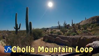
A trail known for its beauty before its ride quality. Any trail with the name cholla in it, should be full of cholla....check Paired with Chuckwagon, it is likely the fastest way from the Browns TH to the diablos.

Real downside with this trail is its ability to kill a riders momentum from either direction. If you can get faster than 8 mph from either direction, I would be surprised. It is more serpentine than flowy and likely better for hikers than for mountain biking. I'd love to see a bypass trail that goes inside the loop and up the mountainSmile

You will like this trail if you are just out for a cruise and want to enjoy the scenery. You won't like it if you enjoy momentum and not being on your brakes the whole time.

Tags
Flowy

Recent Activity on Trail

Past Week
  • 17 rides
  • 22.3 km average
6 Months
  • 154 rides
  • 26.2 km avg distance
All
  • 3,110 rides
  • Last: Nov 18, 2026
c1c2c3c4
January
February
March
April
May
June
July
August
September
October
November
December
Status:
on Nov 10, 2026
Ideal
Avg: 3.78 (13 votes)
Your vote: 0

view (10,997)
close
      Directions to cholla-mtn-loop-22227 trailhead (33.779280, -111.824570)

      Photos

      10 more »
      mtb
      148 |
      Nov 7, 2017 @ 4:55pm
      Nov 7, 2017
      mtb
      158 |
      Nov 7, 2017 @ 4:55pm
      Nov 7, 2017
      mtb
      80 |
      Apr 22, 2021 @ 1:16pm
      Apr 22, 2021
      mtb
      99 |
      Feb 24, 2018 @ 5:14pm
      Feb 24, 2018

      Videos

      2 more »
      youtuber Cholla Mountain Loop
      mtb
      13:43 | 309 | Jan 30, 2026 , Scottsdale
      Brown's Ranch Mountain Biking | Cholla...
      mtb
      17:35 | 265 | Jan 14, 2025 , Scottsdale

      Routes with this trail

      more »
      ★ 3.6 • 14 miles • 865 ft • 39 • Loop •
      Brown’s Ranch Trails will give you a bugs-in-teeth grin as you carve turns on groomed desert...
      ★ 5.0 • 18 miles • 828 ft • 9 • Loop •
      Take Latigo first to get your climbing out of the way. When you hit Hawknest, you get to claim your reward...
      ★ 4.0 • 15 miles • 704 ft • 22 •
      Beautiful route that starts out on Latigo Trail, then takes you in front of Granite Mountain, past...
      3.7 ★★★★★
      13 Ratings
      5 ★ 31%
      4 ★ 31%
      3 ★ 23%
      2 ★ 8%
      1 ★ 8%

      3 Reviews & Comments

      bluedog15 bluedog15
      I’ve ridden this both ways - mega! You gotta love Browns!
      DrHog DrHog
      Great stuff--twisty and fairly smooth with gradual pitch. Can be ridden either direction. Cholla Mtn scenery is gorgeous.

      We hope you've been enjoying Trailforks!

      Create a FREE account to view all trail reviews and much more.

      • By schillingsworthTF Pro TRAILFORKS HTA & contributors
      • #22227 - 2,164 views

      Frequently Asked Questions

      ▼ Where is Cholla Mtn. Loop located?
      Cholla Mtn. Loop is located in Brown's Ranch, Scottsdale, Arizona, United States. It is part of the Brown's Ranch trail network. The trailhead is located at coordinates 33.77928, -111.82457.
      ▼ How hard is Cholla Mtn. Loop?
      Cholla Mtn. Loop is rated as Green difficulty. The physical rating is Moderate. The average grade is 2.686%. The climb difficulty is rated Green.
      ▼ What is the elevation gain for Cholla Mtn. Loop?
      Cholla Mtn. Loop has 163 ft of elevation gain. The trail has 5 ft of elevation descent. The elevation ranges from 2,839 ft to 2,997 ft.
      ▼ Is Cholla Mtn. Loop a point to point trail?
      Cholla Mtn. Loop is not a point to point trail. The direction is Both Directions. The trail type is singletrack.
      ▼ How long is Cholla Mtn. Loop?
      Cholla Mtn. Loop is 1.1 miles long. The trail type is singletrack.
      ▼ Are dogs allowed on Cholla Mtn. Loop?
      Yes, dogs are allowed on Cholla Mtn. Loop. Please keep dogs on a leash where required and clean up after them.
      ▼ When is the best time of year to ride Cholla Mtn. Loop?
      Based on activity log data, the most popular months to ride Cholla Mtn. Loop are:
      • March (225 activities)
      • November (207 activities)
      • February (206 activities)
      Check the reports page for current trail conditions.
      ▼ How do I access Cholla Mtn. Loop? Where is the closest parking trailhead?
      The closest parking and trailhead locations to Cholla Mtn. Loop are: View all parking locations in the area.
      ▼ How long does it take to ride Cholla Mtn. Loop?
      Based on recorded activities, it takes an average of 10 minutes to ride Cholla Mtn. Loop. The trail is 1.1 miles long. Actual times will vary based on fitness level, conditions, and pace. View recent activity logs for more details.
      ▼ How busy is Cholla Mtn. Loop?
      Cholla Mtn. Loop is a very popular trail. There have been 10,713 recorded activities on this trail. The trail has received 10,997 check-ins. View recent activity on this trail.

      Hit the Trail

      Open in App

      Get this trail on your phone instantly.

      open trail in app

      Download Trail

      Save to wishlist, Garmin & download.
      save the trail

      Find Related Routes

      Find routes and users activities that include this trail.
      find routes for this trail

      You must enter a description before submitting.

