more stats
4,622 ft
Distance
80 ft
Climb
-556 ft
Descent
00:06:30
Avg time
-475 ft
Altitude change
1,106 ft
Altitude min
1,586 ft
Altitude max
1,586 ft
Altitude start
1,110 ft
Altitude end
-10.283%
Grade
-60.308%
Grade max
19.709%
Grade min
903 ft
Distance climb
3,294 ft
Distance down
403 ft
Distance flat
00:06:30
Avg time

Colby Switchbacks Details

  • Activities
    • Mountain Bike
    • Hike
    • Trail Running
  • Riding Area
    Glendora
    California
  • Difficulty Rating
  • Local Popularity
    75 in Mountain Biking [+]
    • 5 in Trail Running
    • 100 in Hiking
  • Global Ranking
    #87648 in Mountain Biking [+]
    • #279619 in Trail Running
    • #14881 in Hiking
  • Trail Type
    Singletrack
  • Direction
    Both Directions
    Popular Direction Shown
  • Climb Difficulty
    Black Diamond
  • Physical Rating
    Hard
  • Dogs Allowed
    Yes

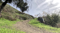
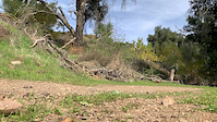
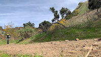
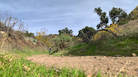
A fun little section of trail that's over all too quickly. Starts with a semi-steep series of switchbacks, before opening it up a bit onto some longer straighter sections. Ends by riding uphill past the dam, and down the road.

The trail seems to be mostly used by bikers and horses, and is reasonably wide + smooth. Its fast and has good gradient, but not so steep as to be punishing. With a little trail work to make better berms/angles on the switchbacks, and to buff out a couple of the fun water bar jumps, this could be one of the best trails around.

Local Trail Association
Traditionally Indigenous Territory

Recent Activity on Trail

Past Week
  • 0 rides
  •  
6 Months
  • 3 rides
  • 5 miles avg distance
All
  • 10 rides
  • Last: Apr 30, 2026
c1c2c3c4
January
February
March
April
May
June
July
August
September
October
November
December
update trails status or condition

Colby Switchbacks Trail Reports

statusdatedescription
Dec 12, 2025 @ 12:45pm (America/Los_Angeles)
Dec 12, 2025
Major erosion (major ruts or slumping, large boulders and roots exposed due to erosion)
Mar 26, 2023 @ 9:58pm
Mar 26, 2023
Jul 15, 2021 @ 12:58pm
Jul 15, 2021
more »
Status:
on Dec 12, 2025
Very Dry
Avg: 3.99 (3 votes)
Your vote: 0

view (337)
close
3D
Trail Conditions
  • Unknown
  • Snow Groomed
  • Snow Packed
  • Snow Covered
  • Snow Cover Partial
  • Freeze/thaw Cycle
  • Icy
  • Prevalent Mud
  • Wet
  • Variable
  • Ideal
  • Dry
  • Very Dry
Trail Flow (Ridden Direction)
Trailforks scans users ridelogs to determine the most popular direction each trail is ridden. A good flowing trail network will have most trails flowing in a single direction according to their intension.
The colour categories are based on what percentage of riders are riding a trail in its intended direction.
  • > 96%
  • > 90%
  • > 80%
  • > 70%
  • > 50%
  • < 50%
  • bi-directional trail
  • no data
Trail Last Ridden
Trailforks scans ridelogs to determine the last time a trail was ridden.
  • < 2 days
  • < 1 week
  • < 2 weeks
  • < 1 month
  • < 6 months
  • > 6 months
Trail Ridden Direction
The intended direction a trail should be ridden.
  • Downhill Only
  • Downhill Primary
  • Both Directions
  • Uphill Primary
  • Uphill Only
  • One Direction
Contribute Details
Colors indicate trail is missing specified detail.
  • Description
  • Photos
  • Description & Photos
  • Videos
Trail Popularity ?
Trailforks scans ridelogs to determine which trails are ridden the most in the last 9 months. Trails are compared with nearby trails in the same city region with a possible 25 colour shades. Think of this as a heatmap, more rides = more kinetic energy = warmer colors.
  • most popular
  • popular
  • less popular
  • not popular
ATV/ORV/OHV Filter
Max Vehicle Width
inches
US Cell Coverage
Legend
cell carrier legend

Radar Time
Activity Recordings
Trailforks uses anonymized public activity data. ?
Activity Recordings
Trailforks uses anonymized public activity data. ?
Personal Heatmap
Activity Types
all / none
Options
2
Date range month
Winter Trails
Warning A routing network for winter maps does not exist. Selecting trails using the winter trails layer has been disabled.
Missing Trails
Most Popular
Least Popular
Trails are colored based on popularity. The more popular a trail is, the more red. Less popular trails trend towards green.
Jump Magnitude Heatmap
Heatmap of where riders jump on trails. Zoom in to see individual jumps, click circles to view jump details.
BC Backroad Status

Service Road Atlas is a free to use, community-driven service for viewing and creating reports on the numerous back-country service roads around B.C. and Alberta.

map legend
Slope Aspect
Direction the slope faces
Flat N NE E SE S SW W NW
Trails Deemphasized
Trails are shown in grey.
disable
Only show trails with no bike usage.
Enable
Suggested Layers
Based on selected activity type

    Save the current map location and zoom level as your default home location whenever this page is loaded.

    Save
        Directions to colby-switchbacks trailhead (34.159107, -117.843089)

        Photos

        1 more »
        90 |
        May 27, 2020 @ 9:27pm
        May 27, 2020

        Videos

        5 more »
        Slow-mo trust performance action
        0:22 | 171 | Jan 3, 2020 , My City
        Slow-mo trust performance action
        0:18 | 31 | Jan 3, 2020 , My City
        Slow-mo trust performance action
        0:27 | 24 | Jan 3, 2020 , My City
        Slow-mo trust performance action
        0:50 | 26 | Jan 3, 2020 , My City

        1 Review & Comments


        We hope you've been enjoying Trailforks!

        Create a FREE account to view trail comments and much more.

        • By toddTF Pro Trailforks & contributors
        • #108111 - 1,094 views

        Frequently Asked Questions About Colby Switchbacks

        Where is Colby Switchbacks located?
        Colby Switchbacks is located in Glendora, California, United States. It is part of the Glendora trail network. The trailhead is located at coordinates 34.15911, -117.84309.
        How hard is Colby Switchbacks?
        Colby Switchbacks is rated as Blue difficulty. The physical rating is Hard. The average grade is 10.283%. The climb difficulty is rated Black Diamond.
        What is the elevation gain for Colby Switchbacks?
        Colby Switchbacks has 80 ft of elevation gain. The trail has 556 ft of elevation descent. The elevation ranges from 1,106 ft to 1,586 ft.
        Is Colby Switchbacks a point to point trail?
        Colby Switchbacks is not a point to point trail. The direction is Both Directions. The trail type is singletrack.

        Hit the Trail

        Open in App

        Get this trail on your phone instantly.
        open trail in app

        Download Trail

        Save to wishlist, Garmin & download.
        save the trail

        Find Related Routes

        Find routes and users activities that include this trail.
        find routes for this trail

        You must enter a description before submitting.