more stats
4,062 ft
Distance
3 ft
Climb
-484 ft
Descent
00:05:43
Avg time
-481 ft
Altitude change
290 ft
Altitude min
774 ft
Altitude max
771 ft
Altitude start
289 ft
Altitude end
-11.9%
Grade
-49.9%
Grade max
3.4%
Grade min
85 ft
Distance climb
3,566 ft
Distance down
410 ft
Distance flat
00:05:43
Avg time

Comò Details

  • Activities
    • Mountain Bike
    • E-Bike
  • Riding Area
  • Difficulty Rating
  • Local Popularity
    100 in Mountain Biking [+]
    • 100 in E-Biking
  • Global Ranking
    #6278 in Mountain Biking [+]
    • #6539 in E-Biking
  • Trail Type
    Singletrack
  • Bike Type
    AM, XC
  • Direction
    Downhill Only
    Popular Direction Shown
  • Trail Visibility
    Always easy to follow
  • eBike Allowed
    Yes up to Class 1

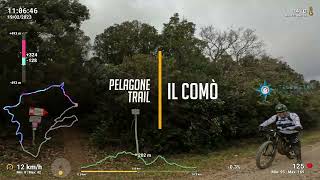
Sentiero flow abbastanza semplice nella prima parte, mentre nell'ultima parte diventa ripido, stretto e con qualche insidia (rocce, gradoni). Se non siete sicuri, a metà prendete la "easy line"
__________________________________________

Fairly easy flow trail in the first part, while in the last part it becomes a little steep, narrow and with some pitfalls (rocks, steps). If you are not sure, halfway take the "easy line"

Trail Supporters
Local Trail Association

Recent Activity on Trail

Past Week
  • 0 rides
  •  
6 Months
  • 2 rides
  • 20 miles avg distance
All
  • 24 rides
  • Last: May 11, 2026
c1c2c3c4
January
February
March
April
May
June
July
August
September
October
November
December
update trails status or condition

Comò Trail Reports

statusdatedescription
May 1, 2025 @ 9:35am
May 1, 2025
Apr 30, 2025 @ 11:08am
Apr 30, 2025
Oct 7, 2024 @ 9:42am
Oct 7, 2024
Apr 28, 2024 @ 3:23am
Apr 28, 2024
sentiero umido causa le piogge frequenti degli ultimi giorni. prestate attenzione.
Apr 16, 2024 @ 3:40am
Apr 16, 2024
more »
Status:
on May 1, 2025
Ideal
Avg: 3.99 (5 votes)
Your vote: 0

view (272)
close
3D
Trail Conditions
  • Unknown
  • Snow Groomed
  • Snow Packed
  • Snow Covered
  • Snow Cover Partial
  • Freeze/thaw Cycle
  • Icy
  • Prevalent Mud
  • Wet
  • Variable
  • Ideal
  • Dry
  • Very Dry
Trail Flow (Ridden Direction)
Trailforks scans users ridelogs to determine the most popular direction each trail is ridden. A good flowing trail network will have most trails flowing in a single direction according to their intension.
The colour categories are based on what percentage of riders are riding a trail in its intended direction.
  • > 96%
  • > 90%
  • > 80%
  • > 70%
  • > 50%
  • < 50%
  • bi-directional trail
  • no data
Trail Last Ridden
Trailforks scans ridelogs to determine the last time a trail was ridden.
  • < 2 days
  • < 1 week
  • < 2 weeks
  • < 1 month
  • < 6 months
  • > 6 months
Trail Ridden Direction
The intended direction a trail should be ridden.
  • Downhill Only
  • Downhill Primary
  • Both Directions
  • Uphill Primary
  • Uphill Only
  • One Direction
Contribute Details
Colors indicate trail is missing specified detail.
  • Description
  • Photos
  • Description & Photos
  • Videos
Trail Popularity ?
Trailforks scans ridelogs to determine which trails are ridden the most in the last 9 months. Trails are compared with nearby trails in the same city region with a possible 25 colour shades. Think of this as a heatmap, more rides = more kinetic energy = warmer colors.
  • most popular
  • popular
  • less popular
  • not popular
ATV/ORV/OHV Filter
Max Vehicle Width
inches
US Cell Coverage
Legend
cell carrier legend

Radar Time
Activity Recordings
Trailforks uses anonymized public activity data. ?
Activity Recordings
Trailforks uses anonymized public activity data. ?
Personal Heatmap
Activity Types
all / none
Options
2
Date range month
Winter Trails
Warning A routing network for winter maps does not exist. Selecting trails using the winter trails layer has been disabled.
Missing Trails
Most Popular
Least Popular
Trails are colored based on popularity. The more popular a trail is, the more red. Less popular trails trend towards green.
Jump Magnitude Heatmap
Heatmap of where riders jump on trails. Zoom in to see individual jumps, click circles to view jump details.
BC Backroad Status

Service Road Atlas is a free to use, community-driven service for viewing and creating reports on the numerous back-country service roads around B.C. and Alberta.

map legend
Slope Aspect
Direction the slope faces
Flat N NE E SE S SW W NW
Trails Deemphasized
Trails are shown in grey.
disable
Only show trails with no bike usage.
Enable
Suggested Layers
Based on selected activity type

    Save the current map location and zoom level as your default home location whenever this page is loaded.

    Save
        Directions to como trailhead (42.975820, 10.884140)

        Photos

        1 more »
        28 |
        Apr 17, 2024 @ 8:24am
        Apr 17, 2024
        46 |
        Apr 17, 2024 @ 8:24am
        Apr 17, 2024
        51 |
        Apr 17, 2024 @ 8:24am
        Apr 17, 2024
        53 |
        Apr 5, 2023 @ 12:24am
        Apr 5, 2023

        Videos

        1 more »
        Pelagone - Comò Trail in E-MTB
        4:23 | 218 | Feb 22, 2023 , Gavorrano

        Reviews / Comments

        No reviews yet, be the first to write a review or ask a question.
        Use trail reports to comment on trail conditions.


        We hope you've been enjoying Trailforks!

        Create a FREE account to view trail comments and much more.

        • By ueppaaTF Pro & contributors
        • #538953 - 636 views

        Frequently Asked Questions About Comò

        Where is Comò located?
        Comò is located in Pelagone Trail Area, Gavorrano, Italy. It is part of the Pelagone Trail Area trail network. The trailhead is located at coordinates 42.97582, 10.88414.
        How hard is Comò?
        Comò is rated as Blue difficulty. The average grade is 11.9%.
        What is the elevation gain for Comò?
        Comò has 3 ft of elevation gain. The trail has 484 ft of elevation descent. The elevation ranges from 290 ft to 774 ft.
        Is Comò a point to point trail?
        Yes, Comò is a point to point trail. The direction is Downhill Only. The trail type is singletrack.

        Hit the Trail

        Open in App

        Get this trail on your phone instantly.
        open trail in app

        Download Trail

        Save to wishlist, Garmin & download.
        save the trail

        Find Related Routes

        Find routes and users activities that include this trail.
        find routes for this trail

        You must enter a description before submitting.