more stats
1,867 ft
Distance
8 ft
Climb
-6 ft
Descent
00:03:30
Avg time
4,228 ft
Altitude min
4,238 ft
Altitude max
4,229 ft
Altitude start
4,229 ft
Altitude end
-3.2%
Grade max
4.9%
Grade min
443 ft
Distance climb
453 ft
Distance down
919 ft
Distance flat
00:03:30
Avg time

Crocus Loop Details

  • Activities
    • Mountain Bike
    • E-Bike
    • Hike
    • Trail Running
    • Snowshoe
  • Riding Area
    Cypress Hills Provincial Park
    Elkwater, Alberta
  • Difficulty Rating
  • Local Popularity
    80 in Mountain Biking [+]
    • 75 in Trail Running
    • 90 in Hiking
    • 5 in Snowshoeing
  • Global Ranking
    #170705 in Mountain Biking [+]
    • #86170 in Trail Running
    • #64421 in Hiking
    • #4784 in Snowshoeing
  • Trail Type
    Singletrack
  • Direction
    Both Directions
  • Dogs Allowed
    Yes
  • eBike Allowed
  • Land Owner
    Cypress Hills Provincial Park

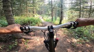
Crocus Loop is a machine built, green trail that serves as a turn around loop for Badger Grind or Firerock trails, though it is a very nice short ride on its own as well. Rides equally well in both directions.

Local Trail Association

Recent Activity on Trail

Past Week
  • 8 rides
  • 9 miles average
6 Months
  • 19 rides
  • 10 miles avg distance
All
  • 161 rides
  • Last: Jun 20, 2026
c1c2c3c4
January
February
March
April
May
June
July
August
September
October
November
December
update trails status or condition

Crocus Loop Trail Reports

Status:
on May 10, 2026
Ideal
no votes yet
Your vote: 0

view (1,019)
close
3D
Trail Conditions
  • Unknown
  • Snow Groomed
  • Snow Packed
  • Snow Covered
  • Snow Cover Partial
  • Freeze/thaw Cycle
  • Icy
  • Prevalent Mud
  • Wet
  • Variable
  • Ideal
  • Dry
  • Very Dry
Trail Flow (Ridden Direction)
Trailforks scans users ridelogs to determine the most popular direction each trail is ridden. A good flowing trail network will have most trails flowing in a single direction according to their intension.
The colour categories are based on what percentage of riders are riding a trail in its intended direction.
  • > 96%
  • > 90%
  • > 80%
  • > 70%
  • > 50%
  • < 50%
  • bi-directional trail
  • no data
Trail Last Ridden
Trailforks scans ridelogs to determine the last time a trail was ridden.
  • < 2 days
  • < 1 week
  • < 2 weeks
  • < 1 month
  • < 6 months
  • > 6 months
Trail Ridden Direction
The intended direction a trail should be ridden.
  • Downhill Only
  • Downhill Primary
  • Both Directions
  • Uphill Primary
  • Uphill Only
  • One Direction
Contribute Details
Colors indicate trail is missing specified detail.
  • Description
  • Photos
  • Description & Photos
  • Videos
Trail Popularity ?
Trailforks scans ridelogs to determine which trails are ridden the most in the last 9 months. Trails are compared with nearby trails in the same city region with a possible 25 colour shades. Think of this as a heatmap, more rides = more kinetic energy = warmer colors.
  • most popular
  • popular
  • less popular
  • not popular
ATV/ORV/OHV Filter
Max Vehicle Width
inches
US Cell Coverage
Legend
cell carrier legend

Radar Time
Activity Recordings
Trailforks uses anonymized public activity data. ?
Activity Recordings
Trailforks uses anonymized public activity data. ?
Personal Heatmap
Activity Types
all / none
Options
2
Date range month
Winter Trails
Warning A routing network for winter maps does not exist. Selecting trails using the winter trails layer has been disabled.
Missing Trails
Most Popular
Least Popular
Trails are colored based on popularity. The more popular a trail is, the more red. Less popular trails trend towards green.
Jump Magnitude Heatmap
Heatmap of where riders jump on trails. Zoom in to see individual jumps, click circles to view jump details.
BC Backroad Status

Service Road Atlas is a free to use, community-driven service for viewing and creating reports on the numerous back-country service roads around B.C. and Alberta.

map legend
Slope Aspect
Direction the slope faces
Flat N NE E SE S SW W NW
Trails Deemphasized
Trails are shown in grey.
disable
Only show trails with no bike usage.
Enable
Suggested Layers
Based on selected activity type

    Save the current map location and zoom level as your default home location whenever this page is loaded.

    Save
        Directions to crocus-loop trailhead (49.657950, -110.315350)

        Photos

        No photos have been added for Crocus Loop yet, add a photo.

        Videos

        1 more »
        Crocus Loop
        2:38 | 223 | Aug 5, 2021 , Elkwater

        Routes with this trail

        5 miles 665 ft 10
        A green campground loop that starts at the Visitor Centre and finishes off on a downhill blue on Old...
        4 miles 440 ft 4
        The weekly ride for the first week of June. This fun loop combines the new trail constructed last year...
        8 miles 1,148 ft 11 Loop
        A quick warm up before biking up to the top of last grizzly for a downhill before a nice relaxing ride...

        1 Review & Comments


        We hope you've been enjoying Trailforks!

        Create a FREE account to view trail comments and much more.

        • By kfbradleyTF Pro & contributors
        • #218045 - 864 views

        Frequently Asked Questions About Crocus Loop

        Where is Crocus Loop located?
        Crocus Loop is located in Cypress Hills Provincial Park, Elkwater, Alberta, Canada. It is part of the Cypress Hills Provincial Park trail network. The trailhead is located at coordinates 49.65795, -110.31535.
        How hard is Crocus Loop?
        Crocus Loop is rated as Green difficulty.
        What is the elevation gain for Crocus Loop?
        Crocus Loop has 8 ft of elevation gain. The trail has 6 ft of elevation descent. The elevation ranges from 4,228 ft to 4,238 ft.
        Is Crocus Loop a point to point trail?
        Crocus Loop is not a point to point trail. The direction is Both Directions. The trail type is singletrack.

        Hit the Trail

        Open in App

        Get this trail on your phone instantly.
        open trail in app

        Download Trail

        Save to wishlist, Garmin & download.
        save the trail

        Find Related Routes

        Find routes and users activities that include this trail.
        find routes for this trail

        You must enter a description before submitting.