

more stats
702 ft
Distance
-95 ft
Descent
00:03:18
Avg time
-95 ft
Altitude change
2,861 ft
Altitude min
2,956 ft
Altitude max
2,956 ft
Altitude start
2,861 ft
Altitude end
-13.5%
Grade
-30.6%
Grade max
-3.3%
Grade min
702 ft
Distance down
00:03:18
Avg time

D' Bockige Line Details

  • Activities
    • Mountain Bike
    • E-Bike
  • Riding Area
  • Ref Number
    #8030
  • Difficulty Rating
  • Local Popularity
    75 in Mountain Biking heatmap [+]
    • 100 in E-Biking
  • Global Ranking
    #6324 in Mountain Biking [+]
    • #10898 in E-Biking
  • National Ranking
    #73 in Mountain Biking · Austria [+]
    • #83 in E-Biking
  • Trail Type
    Singletrack
  • Direction
    Downhill Only
    Popular In Reverse
  • Trail Visibility
    Always easy to follow
  • eBike Allowed
  • Year Opened
    2024

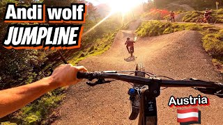
Die "D'Bockige Line" in der "Trailarea Urisee" ist für sehr fortgeschrittene Biker*innen gedacht und ist eine kombinierte Flow- und Jumpline. Von einer Holzkonstruktion mit Rampe geht es in die aus Steilkurven und Sprüngen bestehende Line. Am Halteplatz kann entweder auf die Jumpline oder über einen der beiden Holzdrops gefahren werden. Seitlich gibt es noch eine Variante mit einem Hip. Linksseitig ist die Line anspruchsvoller als auf der rechten Seite. Am Ende wird über einen Step-Up nach oben gesprungen.

Der Start befindet sich knapp unter dem höchsten Punkt des Geländes direkt bei der Treppe der Straßenunterführung (Umfahrung Reutte B179) und mündet in die "D'Oachkätzla Line"(MTB 8028).

Disclaimer

Wearing a helmet is compulsory. Ride at your own risk.

Tags
Jumps

Recent Activity on Trail

Past Week
  • 0 rides
  •  
6 Months
  • 8 rides
  • 4 miles avg distance
All
  • 16 rides
  • Last: Oct 31, 2026
c1c2c3c4
January
February
March
April
May
June
July
August
September
October
November
December
update trails status or condition

D' Bockige Line Trail Reports

Status:
on Sep 7, 2026
Ideal
Avg: 4.11 (3 votes)
Your vote: 0

view (360)
close
      Directions to d--bockige-line trailhead (47.498890, 10.737600)

      Photos

      8 more »
      mtb
      46 |
      Jun 30, 2026 @ 11:11am
      Jun 30, 2026
      mtb
      57 |
      Jun 30, 2026 @ 11:02am
      Jun 30, 2026
      mtb
      43 |
      Jun 30, 2026 @ 11:00am
      Jun 30, 2026
      mtb
      41 |
      Jun 30, 2026 @ 11:00am
      Jun 30, 2026

      Videos

      1 more »
      NEW ANDI WOLF JUMPLINE and local trails: D’...
      mtb
      7:03 | 142 | Aug 31, 2024 , Reutte
      4.4 ★★★★★
      3 Ratings
      5 ★ 33%
      4 ★ 67%
      3 ★
      2 ★
      1 ★

      1 Review & Comments

      Dirlan Dirlan
      Im Zuge der Errichtung der schwarzen Jumpline wurde die seitliche Hip entfernt und der Ablauf zum ersten Sprung entfernt.

      We hope you've been enjoying Trailforks!

      Create a FREE account to view all trail reviews and much more.

      Frequently Asked Questions

      ▼ Where is D' Bockige Line located?
      D' Bockige Line is located in Trailarea Urisee, Reutte, Austria. It is part of the Trailarea Urisee trail network. The trailhead is located at coordinates 47.49889, 10.7376.
      ▼ How hard is D' Bockige Line?
      D' Bockige Line is rated as Red difficulty. The average grade is 13.5%.
      ▼ What is the elevation gain for D' Bockige Line?
      The trail has 95 ft of elevation descent. The elevation ranges from 2,861 ft to 2,956 ft.
      ▼ Is D' Bockige Line a point to point trail?
      Yes, D' Bockige Line is a point to point trail. The direction is Downhill Only. The trail type is singletrack.
      ▼ How long is D' Bockige Line?
      D' Bockige Line is 702 ft long. The trail type is singletrack.
      ▼ Are dogs allowed on D' Bockige Line?
      There is no information about dogs being allowed on D' Bockige Line. Check with local trail managers or the trail page for the latest access rules.
      ▼ When is the best time of year to ride D' Bockige Line?
      Based on activity log data, the most popular months to ride D' Bockige Line are:
      • July (4 activities)
      • October (4 activities)
      • September (3 activities)
      Check the reports page for current trail conditions.
      ▼ How do I access D' Bockige Line? Where is the closest parking trailhead?
      The closest parking and trailhead locations to D' Bockige Line are: View all parking locations in the area.
      ▼ How long does it take to ride D' Bockige Line?
      Based on recorded activities, it takes an average of 3 minutes to ride D' Bockige Line. The trail is 702 ft long. Actual times will vary based on fitness level, conditions, and pace. View recent activity logs for more details.
      ▼ How busy is D' Bockige Line?
      D' Bockige Line is a very popular trail. There have been 41 recorded activities on this trail. The trail has received 360 check-ins. View recent activity on this trail.

      Hit the Trail

      Open in App

      Get this trail on your phone instantly.

      open trail in app

      Download Trail

      Save to wishlist, Garmin & download.
      save the trail

      Find Related Routes

      Find routes and users activities that include this trail.
      find routes for this trail

      You must enter a description before submitting.

