
more stats
3.7 miles
Distance
3 ft
Climb
-2,608 ft
Descent
00:37:02
Avg time
-2,605 ft
Altitude change
7,378 ft
Altitude min
9,987 ft
Altitude max
9,982 ft
Altitude start
7,379 ft
Altitude end
-13.2%
Grade
-80.1%
Grade max
2.1%
Grade min
299 ft
Distance climb
4 miles
Distance down
374 ft
Distance flat
00:37:02
Avg time

Days Fork Trail Details

  • Activities
    • Hike
    • Mountain Bike
    • Trail Running
  • Riding Area
    Big Cottonwood Canyon
    Brighton, Utah
  • Ref Number
    #1160
  • Difficulty Rating
  • Voted Difficulty
    Black Diamond (5 votes)
  • Local Popularity
    20 in Mountain Biking heatmap [+]
    • 30 in Trail Running
    • 10 in Hiking
  • Global Ranking
    #159124 in Mountain Biking [+]
    • #53150 in Trail Running
    • #138505 in Hiking
  • State Ranking
    #3,035 in Mountain Biking · Utah [+]
    • #1,116 in Trail Running
    • #3,172 in Hiking
  • Hiking SAC Scale
    T2 Mountain Hiking
  • Trail Type
    Singletrack
  • Bike Type
    AM
  • Direction
    Downhill Primary
    Popular Direction Shown
  • Climb Difficulty
    Double Black Diamond
  • Physical Rating
    Hard
  • Season
    July - October
  • Alpine Trail
    Yes
  • eBike Allowed
  • TTFs on Trail
    Rock Garden
  • Land Owner
    uinta-wasatch-cache national forest

This is a very steep and often loose descent of the Days Fork Trail, dropping from the ridgeline of BCC/LCC down to the Spruces Campground (the softball field). There are hike-a-bike sections along the ridgeline.

The Flagstaff & Emma Ridge traverse has a lot of non-rideable sections for bikes, if you are accessing Days Fork from the top on the LCC side.

Access Info

Easiest access is up from the bottom, and turning back once you gain the ridge looking down into Alta. Beyond is the Emma Ridge trail which includes a great deal of steep loose hike-a-bike sections. These are possible to traverse if making a loop, but an adventurous mindset is required.

Tags

Trail Supporters

Traditionally Indigenous Territory

Recent Activity on Trail

Past Week
  • 0 rides
  •  
6 Months
  • 3 rides
  • 14 miles avg distance
All
  • 16 rides
  • Last: Sep 10, 2026
c1c2c3c4
January
February
March
April
May
June
July
August
September
October
November
December
update trails status or condition

Days Fork Trail Trail Reports

statusdatedescription
Sep 11, 2026 @ 12:48pm (America/Denver)
Sep 11, 2026
The trail built by neglect. No down trees but if there were it would not make much difference on the difficulty of riding this trail in its...
Jun 28, 2025 @ 7:33am
Jun 28, 2025
Tree down near top and a few small snow patches. Trail has some dry creek bed crossings
Aug 25, 2024 @ 9:14pm
Aug 25, 2024
Beat up, with rideable wash-outs in the bowl, 3 major wash-outs on the rest of it. The bottom of the steeps in the upper valley is the dried...
Jun 20, 2024 @ 12:26am
Jun 20, 2024
Upper Days Fork is pretty snowed in still, hike-a-bike and need a GPS to track the trail. Once it cross that creek gets a litter better. Typical...
Aug 12, 2023 @ 4:24pm
Aug 12, 2023
Trail is thrashed from the last storm. Rideable but there are sections that are completely washed out. No longer the fast ripper that it once was....
more »
Status:
on Sep 11, 2026
Dry
Avg: 3.53 (11 votes)
Your vote: 0

view (255)
close
      Directions to days-fork-trail trailhead (40.599170, -111.630320)

      Photos

      18 more »
      mtb
      266 |
      Sep 22, 2020 @ 11:11am
      Sep 22, 2020
      mtb
      248 |
      Sep 22, 2020 @ 11:11am
      Sep 22, 2020
      mtb
      208 |
      Sep 22, 2020 @ 11:11am
      Sep 22, 2020
      mtb
      203 |
      Sep 22, 2020 @ 11:11am
      Sep 22, 2020

      Videos

      2 more »
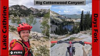
      youtuber Lake Cathrine to Days Fork in Big Cottonwood...
      mtb
      54:19 | 66 | Jul 31, 2026 , Brighton
      Days Fork Trail - Big Cottonwood Canyon
      mtb
      665 | Sep 21, 2018 , Brighton

      Routes with this trail

      more »
      32 miles • 7,568 ft • 12 • Loop •
      Climb Solitude, Over to Catherines, Drop into Alta, Over to Snowbird, Down Big Mtn, Up and over to Solitude
      29 miles • 8,996 ft • 9 •
      Starting at Solitude, BCC-LCC-BCC-Crest and back
      7 miles • 2,618 ft • 2 •
      3.3 ★★★★★
      11 Ratings
      5 ★ 18%
      4 ★ 27%
      3 ★ 36%
      2 ★
      1 ★ 18%

      9 Reviews & Comments

      NSmith11
      I agreed with the comment to rate this blue back in 2020. At the time of this post it is not that same trail. In the current state of complete neglect and damage there are significant naturally built TTF's and large loose debris throughout. Easily as challenging as its neighbor Honeycomb right now. If the USFS ever decided to maintain this trail again it would go back to blue.
      EZRhino EZRhino
      Trail completely clear of deadfall as of Aug 9, 2025.
      Paunch
      Anyone know if the trees have been cleared since the windstorm?

      We hope you've been enjoying Trailforks!

      Create a FREE account to view all trail reviews and much more.

      • By UtahJohnTF Pro TRAILFORKS & contributors
      • #116500 - 5,753 views

      Frequently Asked Questions

      ▼ Where is Days Fork Trail located?
      Days Fork Trail is located in Big Cottonwood Canyon, Brighton, Utah, United States. It is part of the Big Cottonwood Canyon trail network. The trailhead is located at coordinates 40.59917, -111.63032.
      ▼ How hard is Days Fork Trail?
      Days Fork Trail is rated as Black Diamond difficulty. The physical rating is Hard. The average grade is 13.2%. The climb difficulty is rated Double Black Diamond.
      ▼ What is the elevation gain for Days Fork Trail?
      Days Fork Trail has 3 ft of elevation gain. The trail has 2,608 ft of elevation descent. The elevation ranges from 7,378 ft to 9,987 ft.
      ▼ Is Days Fork Trail a point to point trail?
      Days Fork Trail is not a point to point trail. The direction is Downhill Primary. The trail type is singletrack.
      ▼ How long is Days Fork Trail?
      Days Fork Trail is 3.7 miles long. The trail type is singletrack.
      ▼ Are dogs allowed on Days Fork Trail?
      There is no information about dogs being allowed on Days Fork Trail. Check with local trail managers or the trail page for the latest access rules.
      ▼ When is the best time of year to ride Days Fork Trail?
      Based on activity log data, the most popular months to ride Days Fork Trail are:
      • July (2 activities)
      • August (1 activities)
      • September (1 activities)
      Check the reports page for current trail conditions.
      ▼ How do I access Days Fork Trail? Where is the closest parking trailhead?
      The closest parking and trailhead locations to Days Fork Trail are: View all parking locations in the area.
      ▼ How long does it take to ride Days Fork Trail?
      Based on recorded activities, it takes an average of 37 minutes to ride Days Fork Trail. The trail is 3.7 miles long. Actual times will vary based on fitness level, conditions, and pace. View recent activity logs for more details.
      ▼ How busy is Days Fork Trail?
      Days Fork Trail is a less popular trail with lighter traffic. There have been 246 recorded activities on this trail. The trail has received 255 check-ins. View recent activity on this trail.

      Hit the Trail

      Open in App

      Get this trail on your phone instantly.

      open trail in app

      Download Trail

      Save to wishlist, Garmin & download.
      save the trail

      Find Related Routes

      Find routes and users activities that include this trail.
      find routes for this trail

      You must enter a description before submitting.


