more stats
1.6 miles
Distance
37 ft
Climb
-444 ft
Descent
00:10:05
Avg time
-406 ft
Altitude change
8,196 ft
Altitude min
8,635 ft
Altitude max
8,602 ft
Altitude start
8,196 ft
Altitude end
-4.9%
Grade
-25.8%
Grade max
13.9%
Grade min
1,066 ft
Distance climb
1 mile
Distance down
886 ft
Distance flat
00:10:05
Avg time

Deadline Details

  • Activities
    • Mountain Bike
  • Riding Area
    Sky Mountain Park
    Aspen, Colorado
  • Difficulty Rating
  • Local Popularity
    100 in Mountain Biking
  • Global Ranking
    #34965 in Mountain Biking
  • Trail Type
    Singletrack
  • Bike Type
    DH, AM, XC
  • Direction
    Downhill Only
  • Climb Difficulty
    Blue
  • Physical Rating
    Moderate
  • Season
    May 16-Nov 30th
  • eBike Allowed
  • TTFs on Trail
    Berm, Drop, Jump
  • Land Owner
    Pitkin County

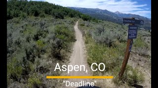
This is a new trail constructed during Summer of 2014. It is being managed as a recommended downhill directional trail given the many jumps along the trail. Access the trail from the top of the Viewline trail at western end of Skyline Ridge trail. With the opening of Deadline, Viewline trail will now be signed as recommended only for uphill bike travel.

This trail is another first of its kind for the Aspen / Snowmass area. It's a bike optimized directional flow trail that features large, generous in-sloped berm turns, rollers, table top jumps, drop offs, and a couple doubles that can be easily gapped at speed. The width of the trail and ability to roll over just about every one of the jumps (if you slow down enough) gives this trail an intermediate rating. At full speed, the trail is definitely in the expert/difficult category. While the views towards Snowmass and the forests of the Government Trail are excellent, your eyes will mostly be focused on the trail

Use this trail as part of a tour of Sky Mountain Park, or part of a longer ride linking Airline Trail to Skyline Ridge trail to Deadline trail to Highline trail to Tom Blake trail to Powerline to Government Trail. Or, park at the Rodeo Lot or smaller parking lot along Owl Creek Road and take multiple laps on Viewline trail - Deadline Trail - Highline trail.

Trail Supporters
Traditionally Indigenous Territory

Recent Activity on Trail

Past Week
  • 10 rides
  • 14 miles average
6 Months
  • 10 rides
  • 14 miles avg distance
All
  • 463 rides
  • Last: Jul 3, 2026
c1c2c3c4
January
February
March
April
May
June
July
August
September
October
November
December
update trails status or condition

Deadline Trail Reports

statusdatedescription
Jun 26, 2026 @ 4:36pm (America/Denver)
Jun 26, 2026
Trail is open again after completion of construction upgrades
Jun 21, 2026 @ 11:18pm (America/Denver)
Jun 21, 2026
Closed for massive trail maintenance. As of 6/21/2026 there are signs that say completion date TBD.
Aug 5, 2025 @ 10:14am
Aug 5, 2025
Aug 5, 2025 @ 10:14am
Aug 5, 2025
Jul 19, 2025 @ 7:37am
Jul 19, 2025
more »
Status:
on Jun 26, 2026
Dry
Avg: 4.26 (9 votes)
Your vote: 0

view (3,654)
close
3D
Trail Conditions
  • Unknown
  • Snow Groomed
  • Snow Packed
  • Snow Covered
  • Snow Cover Partial
  • Freeze/thaw Cycle
  • Icy
  • Prevalent Mud
  • Wet
  • Variable
  • Ideal
  • Dry
  • Very Dry
Trail Flow (Ridden Direction)
Trailforks scans users ridelogs to determine the most popular direction each trail is ridden. A good flowing trail network will have most trails flowing in a single direction according to their intension.
The colour categories are based on what percentage of riders are riding a trail in its intended direction.
  • > 96%
  • > 90%
  • > 80%
  • > 70%
  • > 50%
  • < 50%
  • bi-directional trail
  • no data
Trail Last Ridden
Trailforks scans ridelogs to determine the last time a trail was ridden.
  • < 2 days
  • < 1 week
  • < 2 weeks
  • < 1 month
  • < 6 months
  • > 6 months
Trail Ridden Direction
The intended direction a trail should be ridden.
  • Downhill Only
  • Downhill Primary
  • Both Directions
  • Uphill Primary
  • Uphill Only
  • One Direction
Contribute Details
Colors indicate trail is missing specified detail.
  • Description
  • Photos
  • Description & Photos
  • Videos
Trail Popularity ?
Trailforks scans ridelogs to determine which trails are ridden the most in the last 9 months. Trails are compared with nearby trails in the same city region with a possible 25 colour shades. Think of this as a heatmap, more rides = more kinetic energy = warmer colors.
  • most popular
  • popular
  • less popular
  • not popular
ATV/ORV/OHV Filter
Max Vehicle Width
inches
US Cell Coverage
Legend
cell carrier legend

Radar Time
Activity Recordings
Trailforks uses anonymized public activity data. ?
Activity Recordings
Trailforks uses anonymized public activity data. ?
Personal Heatmap
Activity Types
all / none
Options
2
Date range month
Winter Trails
Warning A routing network for winter maps does not exist. Selecting trails using the winter trails layer has been disabled.
Missing Trails
Most Popular
Least Popular
Trails are colored based on popularity. The more popular a trail is, the more red. Less popular trails trend towards green.
Jump Magnitude Heatmap
Heatmap of where riders jump on trails. Zoom in to see individual jumps, click circles to view jump details.
BC Backroad Status

Service Road Atlas is a free to use, community-driven service for viewing and creating reports on the numerous back-country service roads around B.C. and Alberta.

map legend
Slope Aspect
Direction the slope faces
Flat N NE E SE S SW W NW
Trails Deemphasized
Trails are shown in grey.
disable
Only show trails with no bike usage.
Enable
Suggested Layers
Based on selected activity type

    Save the current map location and zoom level as your default home location whenever this page is loaded.

    Save
        Directions to deadline trailhead (39.219960, -106.910040)

        Photos

        16 more »
        32 |
        Aug 9, 2025 @ 6:13pm
        Aug 9, 2025
        33 |
        Aug 9, 2025 @ 6:13pm
        Aug 9, 2025
        27 |
        Aug 9, 2025 @ 6:13pm
        Aug 9, 2025
        33 |
        Aug 9, 2025 @ 6:13pm
        Aug 9, 2025

        Videos

        2 more »
        Aspen Sky Mountain Park MTB trail - 'Deadline'
        7:36 | 83 | Aug 9, 2025 , Aspen
        Deadline Trail in Snowmass Village - at 2X...
        957 | Jul 6, 2017 , Aspen

        Routes with this trail

        5.0 18 miles 2,196 ft 8 Loop
        Ride the Skyline Ridge Adventure to experience an excellent selection of Snowmass trails. Expect a decent...
        58 miles 8,920 ft 19 Loop
        33 miles 5,521 ft 35 Loop
        Trying to find a way to loop Snomwass and Governement.

        4 Reviews & Comments


        We hope you've been enjoying Trailforks!

        Create a FREE account to view trail comments and much more.

        Nearby Trails

        • By toddTF Pro Trailforks & contributors
        • #27340 - 3,050 views

        Frequently Asked Questions About Deadline

        Where is Deadline located?
        Deadline is located in Sky Mountain Park, Aspen, Colorado, United States. It is part of the Sky Mountain Park trail network. The trailhead is located at coordinates 39.21996, -106.91004.
        How hard is Deadline?
        Deadline is rated as Black Diamond difficulty. The physical rating is Moderate. The average grade is 4.9%. The climb difficulty is rated Blue.
        What is the elevation gain for Deadline?
        Deadline has 37 ft of elevation gain. The trail has 444 ft of elevation descent. The elevation ranges from 8,196 ft to 8,635 ft.
        Is Deadline a point to point trail?
        Yes, Deadline is a point to point trail. The direction is Downhill Only. The trail type is singletrack.

        Hit the Trail

        Open in App

        Get this trail on your phone instantly.
        open trail in app

        Download Trail

        Save to wishlist, Garmin & download.
        save the trail

        Find Related Routes

        Find routes and users activities that include this trail.
        find routes for this trail

        You must enter a description before submitting.