more stats
1.9 miles
Distance
710 ft
Climb
00:24:50
Avg time
710 ft
Altitude change
7,889 ft
Altitude min
8,598 ft
Altitude max
7,889 ft
Altitude start
8,599 ft
Altitude end
7.1%
Grade
-1.6%
Grade max
41.8%
Grade min
2 miles
Distance climb
52 ft
Distance down
171 ft
Distance flat
00:24:50
Avg time

Viewline Details

  • Activities
    • Mountain Bike
    • Hike
    • Trail Running
  • Riding Area
    Sky Mountain Park
    Aspen, Colorado
  • Difficulty Rating
  • Local Popularity
    90 in Mountain Biking [+]
    • 45 in Trail Running
    • 40 in Hiking
  • Global Ranking
    #51937 in Mountain Biking [+]
    • #98917 in Trail Running
    • #111674 in Hiking
  • Trail Type
    Singletrack
  • Direction
    Both Directions
  • Climb Difficulty
    Blue
  • Physical Rating
    Moderate
  • Trail Visibility
    Always easy to follow
  • eBike Allowed
  • Land Owner
    Pitkin County

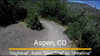
This singletrack allows access to Sky Mountain Park and the excellent Skyline Ridge trail from the western Snowmass Village side. Access the trail via either end of the Highline trail or from the east. From the Aspen side, via Skyline Ridge trail, this is a fun descent through open meadows and scrub oaks, huge views of Snowmass distracting you all the way down. While some of the switchbacks / turns don't have a perfect downhill flow, this is less of a concern for riders since the opening of the Deadline Trail, which is now the recommended downhill trail from Skyline Ridge trail, while Viewline is the recommended ascent trail for climbing up to the ridge.

Watch out for hikers as there are a number of blind corners.

When ridden as a climb from the Snowmass side, you'll find that the grade is not too steep most of the time, although a few of the lower switchbacks present steep short challenges. The lowest section of the trail, which connects to the roundabout area and nearby Rodeo parking lot, was rerouted and improved with generous bermed turns in October 2015. This reworked section of trail was previously considered the northern end of Highline trail.

Traditionally Indigenous Territory

Recent Activity on Trail

Past Week
  • 1 rides
  • 24 miles average
6 Months
  • 15 rides
  • 16 miles avg distance
All
  • 224 rides
  • Last: Jun 26, 2026
c1c2c3c4
January
February
March
April
May
June
July
August
September
October
November
December
update trails status or condition

Viewline Trail Reports

statusdatedescription
Sep 16, 2023 @ 1:04pm
Sep 16, 2023
Perfect!
Jul 12, 2023 @ 9:25am
Jul 12, 2023
May 31, 2022 @ 6:31pm
May 31, 2022
Nov 4, 2021 @ 12:07pm
Nov 4, 2021
Wet throughout with mud in many places where the snow is still melting.
Jun 27, 2021 @ 10:46am
Jun 27, 2021
more »
Status:
on Sep 16, 2023
Ideal
Avg: 4.21 (3 votes)
Your vote: 0

view (1,419)
close
3D
Trail Conditions
  • Unknown
  • Snow Groomed
  • Snow Packed
  • Snow Covered
  • Snow Cover Partial
  • Freeze/thaw Cycle
  • Icy
  • Prevalent Mud
  • Wet
  • Variable
  • Ideal
  • Dry
  • Very Dry
Trail Flow (Ridden Direction)
Trailforks scans users ridelogs to determine the most popular direction each trail is ridden. A good flowing trail network will have most trails flowing in a single direction according to their intension.
The colour categories are based on what percentage of riders are riding a trail in its intended direction.
  • > 96%
  • > 90%
  • > 80%
  • > 70%
  • > 50%
  • < 50%
  • bi-directional trail
  • no data
Trail Last Ridden
Trailforks scans ridelogs to determine the last time a trail was ridden.
  • < 2 days
  • < 1 week
  • < 2 weeks
  • < 1 month
  • < 6 months
  • > 6 months
Trail Ridden Direction
The intended direction a trail should be ridden.
  • Downhill Only
  • Downhill Primary
  • Both Directions
  • Uphill Primary
  • Uphill Only
  • One Direction
Contribute Details
Colors indicate trail is missing specified detail.
  • Description
  • Photos
  • Description & Photos
  • Videos
Trail Popularity ?
Trailforks scans ridelogs to determine which trails are ridden the most in the last 9 months. Trails are compared with nearby trails in the same city region with a possible 25 colour shades. Think of this as a heatmap, more rides = more kinetic energy = warmer colors.
  • most popular
  • popular
  • less popular
  • not popular
ATV/ORV/OHV Filter
Max Vehicle Width
inches
US Cell Coverage
Legend
cell carrier legend

Radar Time
Activity Recordings
Trailforks uses anonymized public activity data. ?
Activity Recordings
Trailforks uses anonymized public activity data. ?
Personal Heatmap
Activity Types
all / none
Options
2
Date range month
Winter Trails
Warning A routing network for winter maps does not exist. Selecting trails using the winter trails layer has been disabled.
Missing Trails
Most Popular
Least Popular
Trails are colored based on popularity. The more popular a trail is, the more red. Less popular trails trend towards green.
Jump Magnitude Heatmap
Heatmap of where riders jump on trails. Zoom in to see individual jumps, click circles to view jump details.
BC Backroad Status

Service Road Atlas is a free to use, community-driven service for viewing and creating reports on the numerous back-country service roads around B.C. and Alberta.

map legend
Slope Aspect
Direction the slope faces
Flat N NE E SE S SW W NW
Trails Deemphasized
Trails are shown in grey.
disable
Only show trails with no bike usage.
Enable
Suggested Layers
Based on selected activity type

    Save the current map location and zoom level as your default home location whenever this page is loaded.

    Save
        Directions to viewline trailhead (39.225060, -106.920290)

        Photos

        5 more »
        36 |
        Aug 11, 2025 @ 4:23pm
        Aug 11, 2025
        26 |
        Aug 11, 2025 @ 4:23pm
        Aug 11, 2025
        73 |
        Oct 21, 2018 @ 10:29am
        Oct 21, 2018
        263 |
        Jun 11, 2015 @ 5:09am
        Jun 11, 2015

        Videos

        1 more »
        Aspen Sky Mountain Park MTB trails -...
        5:07 | 71 | Aug 11, 2025 , Aspen

        Routes with this trail

        33 miles 5,521 ft 35 Loop
        Trying to find a way to loop Snomwass and Governement.

        Reviews / Comments

        No reviews yet, be the first to write a review or ask a question.
        Use trail reports to comment on trail conditions.


        We hope you've been enjoying Trailforks!

        Create a FREE account to view trail comments and much more.

        • By toddTF Pro Trailforks & contributors
        • #14043 - 1,816 views

        Frequently Asked Questions About Viewline

        Where is Viewline located?
        Viewline is located in Sky Mountain Park, Aspen, Colorado, United States. It is part of the Sky Mountain Park trail network. The trailhead is located at coordinates 39.22506, -106.92029.
        How hard is Viewline?
        Viewline is rated as Blue difficulty. The physical rating is Moderate. The average grade is 7.1%. The climb difficulty is rated Blue.
        What is the elevation gain for Viewline?
        Viewline has 710 ft of elevation gain. The elevation ranges from 7,889 ft to 8,598 ft.
        Is Viewline a point to point trail?
        Viewline is not a point to point trail. The direction is Both Directions. The trail type is singletrack.

        Hit the Trail

        Open in App

        Get this trail on your phone instantly.
        open trail in app

        Download Trail

        Save to wishlist, Garmin & download.
        save the trail

        Find Related Routes

        Find routes and users activities that include this trail.
        find routes for this trail

        You must enter a description before submitting.