more stats
1.5 miles
Distance
71 ft
Climb
-118 ft
Descent
00:13:26
Avg time
-48 ft
Altitude change
1,155 ft
Altitude min
1,203 ft
Altitude max
1,203 ft
Altitude start
1,155 ft
Altitude end
-0.6%
Grade
-9.6%
Grade max
10.1%
Grade min
1,923 ft
Distance climb
3,543 ft
Distance down
2,625 ft
Distance flat
00:13:26
Avg time

Dipper Details

  • Activities
    • Mountain Bike
    • E-Bike
    • Gravel Bike
    • Adaptive Bike
    • Winter Fat Bike
  • Riding Area
  • AKA
    The Dipper
  • Difficulty Rating
  • Voted Difficulty
    Black Diamond (1 vote)
  • Local Popularity
    80 in Mountain Biking [+]
    • 75 in E-Biking
  • Global Ranking
    #1869 in Mountain Biking [+]
    • #24460 in E-Biking
  • Trail Type
    Singletrack
  • Bike Type
    AM, XC, Fat, Adaptive MTB, CX, Gravel
  • Direction
    One Direction
    Popular Direction Shown
  • Climb Difficulty
    Green
  • Physical Rating
    Easy
  • Trail Visibility
    Always easy to follow
  • Family Friendly
    Yes
  • Dogs Allowed
    Yes
  • eBike Allowed
    Yes up to Class 1

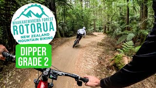
One of Whakarewarewa forest's originals and if there is an iconic trail this is The One. Highly recommended for families and beginners. Mostly flat flowing trail with good berms, great introduction to riding for first timers or a warm/up down for more experienced riders. Popular for families with wide tracks to overtake slower riders.
Like all the trails rebuilt and revamped after extensive forestry operations, the brief was to retain the shape, style and length of the original. It was also important that the trail remained what it has always been: family-friendly and also a fast, flat workout for the experienced riders. Success

The series of well-engineered berms at the start of The Dipper is now better, evened-out and faster. WICKED – put the hammer down and see if you can lose those following. The revamped trail features more rollers, jumps (safely tabled topped, so you can roll then) and even more berms.
The actual Dipper feature is an optional 'hard line' now, with two easier lines around it keeping the entire trail within a grade 2 classification.

Pop out after the Dipper (which is where you came into the trail) onto Pohaturoa Rd or keep going and there are more berms after this. Including The Big Berm built by the Corrections guys 15 years ago. They also did some major maintenance on this in November 2009.

The Big Berm was groomed in the revamp and is still a major fun factor on the trail. The following section looping through the mature Douglas Fir has been tidied up with increased flow and the occasional smooth table top jump.

source: Ride Rotorua
Access Info

Starts off Pohaturoa Rd near the intersection of Nursery Rd.

Trail Supporters
Local Trail Association

Recent Activity on Trail

Past Week
  • 4 rides
  • 13 miles average
6 Months
  • 236 rides
  • 16 miles avg distance
All
  • 1,462 rides
  • Last: Jun 22, 2026
c1c2c3c4
January
February
March
April
May
June
July
August
September
October
November
December
update trails status or condition

Dipper Trail Reports

Status:
on May 14, 2026
Ideal
Avg: 4.17 (41 votes)
Your vote: 0

view (7,601)
close
3D
Trail Conditions
  • Unknown
  • Snow Groomed
  • Snow Packed
  • Snow Covered
  • Snow Cover Partial
  • Freeze/thaw Cycle
  • Icy
  • Prevalent Mud
  • Wet
  • Variable
  • Ideal
  • Dry
  • Very Dry
Trail Flow (Ridden Direction)
Trailforks scans users ridelogs to determine the most popular direction each trail is ridden. A good flowing trail network will have most trails flowing in a single direction according to their intension.
The colour categories are based on what percentage of riders are riding a trail in its intended direction.
  • > 96%
  • > 90%
  • > 80%
  • > 70%
  • > 50%
  • < 50%
  • bi-directional trail
  • no data
Trail Last Ridden
Trailforks scans ridelogs to determine the last time a trail was ridden.
  • < 2 days
  • < 1 week
  • < 2 weeks
  • < 1 month
  • < 6 months
  • > 6 months
Trail Ridden Direction
The intended direction a trail should be ridden.
  • Downhill Only
  • Downhill Primary
  • Both Directions
  • Uphill Primary
  • Uphill Only
  • One Direction
Contribute Details
Colors indicate trail is missing specified detail.
  • Description
  • Photos
  • Description & Photos
  • Videos
Trail Popularity ?
Trailforks scans ridelogs to determine which trails are ridden the most in the last 9 months. Trails are compared with nearby trails in the same city region with a possible 25 colour shades. Think of this as a heatmap, more rides = more kinetic energy = warmer colors.
  • most popular
  • popular
  • less popular
  • not popular
ATV/ORV/OHV Filter
Max Vehicle Width
inches
US Cell Coverage
Legend
cell carrier legend

Radar Time
Activity Recordings
Trailforks uses anonymized public activity data. ?
Activity Recordings
Trailforks uses anonymized public activity data. ?
Personal Heatmap
Activity Types
all / none
Options
2
Date range month
Winter Trails
Warning A routing network for winter maps does not exist. Selecting trails using the winter trails layer has been disabled.
Missing Trails
Most Popular
Least Popular
Trails are colored based on popularity. The more popular a trail is, the more red. Less popular trails trend towards green.
Jump Magnitude Heatmap
Heatmap of where riders jump on trails. Zoom in to see individual jumps, click circles to view jump details.
BC Backroad Status

Service Road Atlas is a free to use, community-driven service for viewing and creating reports on the numerous back-country service roads around B.C. and Alberta.

map legend
Slope Aspect
Direction the slope faces
Flat N NE E SE S SW W NW
Trails Deemphasized
Trails are shown in grey.
disable
Only show trails with no bike usage.
Enable
Suggested Layers
Based on selected activity type

    Save the current map location and zoom level as your default home location whenever this page is loaded.

    Save
        Directions to dipper trailhead (-38.170120, 176.266560)

        Photos

        49 more »
        181 |
        Feb 12, 2017 @ 1:18am
        Feb 12, 2017
        526 |
        Feb 11, 2017 @ 8:21pm
        Feb 11, 2017
        534 |
        Apr 7, 2010 @ 1:24am
        Apr 7, 2010
        417 |
        Dec 1, 2013 @ 12:15am
        Dec 1, 2013

        Videos

        9 more »
        youtuber The Dipper - Redwoods, Rotorua [Ep#31]
        7:11 | 1122 | Apr 26, 2018 , Rotorua
        youtuber The PERFECT TRAIL to Start | Dipper Trail, Rotorua
        7:51 | 262 | Dec 3, 2024 , Rotorua
        Dipper Aug2019
        10:14 | 745 | Aug 13, 2019 , Rotorua
        Pohaturoa track nz
        3:23 | 996 | Jun 27, 2018 , Rotorua

        Trail Lists

        Routes with this trail

        4.0 5 miles 347 ft 11 Loop
        This is an awesome easy loop in Rotorua that starts and finishes at the main parking area of the...
        4.0 6 miles 476 ft 12 Loop
        This is a great beginner mountain bike loop in the Whakarewarewa Forest in Rotorua New Zealand.
        12 miles 887 ft 28 Loop
        First time Mountain Biking? This loop is your baby, taking in one of the most scenic trails and linking...

        2 Reviews & Comments


        We hope you've been enjoying Trailforks!

        Create a FREE account to view trail comments and much more.

        Frequently Asked Questions About Dipper

        Where is Dipper located?
        Dipper is located in Whakarewarewa Forest, Rotorua, New Zealand. It is part of the Whakarewarewa Forest trail network. The trailhead is located at coordinates -38.17012, 176.26656.
        How hard is Dipper?
        Dipper is rated as Green difficulty. The physical rating is Easy. The average grade is 0.6%. The climb difficulty is rated Green.
        What is the elevation gain for Dipper?
        Dipper has 71 ft of elevation gain. The trail has 118 ft of elevation descent. The elevation ranges from 1,155 ft to 1,203 ft.
        Is Dipper a point to point trail?
        Yes, Dipper is a point to point trail. The direction is One Direction. The trail type is singletrack.

        Hit the Trail

        Open in App

        Get this trail on your phone instantly.
        open trail in app

        Download Trail

        Save to wishlist, Garmin & download.
        save the trail

        Find Related Routes

        Find routes and users activities that include this trail.
        find routes for this trail

        You must enter a description before submitting.