more stats
1,040 ft
Distance
-164 ft
Descent
00:03:02
Avg time
-164 ft
Altitude change
2,188 ft
Altitude min
2,352 ft
Altitude max
2,352 ft
Altitude start
2,188 ft
Altitude end
-15.8%
Grade
-31%
Grade max
-8%
Grade min
1,040 ft
Distance down
00:03:02
Avg time

Dirty Distancing Details

  • Activities
    • Mountain Bike
    • Hike
    • Trail Running
  • Riding Area
    Majura Pines
    Canberra
  • Difficulty Rating
  • Local Popularity
    90 in Mountain Biking [+]
    • 5 in Trail Running
    • 80 in Hiking
  • Global Ranking
    #123820 in Mountain Biking [+]
    • #139429 in Trail Running
    • #51296 in Hiking
  • Blaze Color
  • Trail Type
    Singletrack
  • Bike Type
    DH, AM
  • Direction
    Downhill Only
  • Dogs Allowed
    Yes
  • eBike Allowed
  • TTFs on Trail
    Berm, Drop, Jump, Gap Jump, Log Ride, Rock Garden

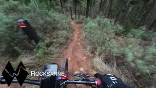
Starting at the same place as Point Brake, don't let the the first swoopy berms fool you. Once you as past the A/B - log ride or huck off tree stump - then this trail gets steep and gnarly. When you finally reach the bottom of the gully the really (really) good riders have a hip jump down. For mere mortals (you must be a pretty good rider just to get this far) there is a B line round to the right. The trail then joins Point Brake again for the last few turns.

Local Trail Association
Traditionally Indigenous Territory

Recent Activity on Trail

Past Week
  • 1 rides
  • 7 miles average
6 Months
  • 35 rides
  • 14 miles avg distance
All
  • 305 rides
  • Last: Jun 28, 2026
c1c2c3c4
January
February
March
April
May
June
July
August
September
October
November
December
update trails status or condition

Dirty Distancing Trail Reports

Status:
on Feb 16, 2025
Very Dry
Avg: 5 (1 votes)
Your vote: 0

view (2,838)
close
3D
Trail Conditions
  • Unknown
  • Snow Groomed
  • Snow Packed
  • Snow Covered
  • Snow Cover Partial
  • Freeze/thaw Cycle
  • Icy
  • Prevalent Mud
  • Wet
  • Variable
  • Ideal
  • Dry
  • Very Dry
Trail Flow (Ridden Direction)
Trailforks scans users ridelogs to determine the most popular direction each trail is ridden. A good flowing trail network will have most trails flowing in a single direction according to their intension.
The colour categories are based on what percentage of riders are riding a trail in its intended direction.
  • > 96%
  • > 90%
  • > 80%
  • > 70%
  • > 50%
  • < 50%
  • bi-directional trail
  • no data
Trail Last Ridden
Trailforks scans ridelogs to determine the last time a trail was ridden.
  • < 2 days
  • < 1 week
  • < 2 weeks
  • < 1 month
  • < 6 months
  • > 6 months
Trail Ridden Direction
The intended direction a trail should be ridden.
  • Downhill Only
  • Downhill Primary
  • Both Directions
  • Uphill Primary
  • Uphill Only
  • One Direction
Contribute Details
Colors indicate trail is missing specified detail.
  • Description
  • Photos
  • Description & Photos
  • Videos
Trail Popularity ?
Trailforks scans ridelogs to determine which trails are ridden the most in the last 9 months. Trails are compared with nearby trails in the same city region with a possible 25 colour shades. Think of this as a heatmap, more rides = more kinetic energy = warmer colors.
  • most popular
  • popular
  • less popular
  • not popular
ATV/ORV/OHV Filter
Max Vehicle Width
inches
US Cell Coverage
Legend
cell carrier legend

Radar Time
Activity Recordings
Trailforks uses anonymized public activity data. ?
Activity Recordings
Trailforks uses anonymized public activity data. ?
Personal Heatmap
Activity Types
all / none
Options
2
Date range month
Winter Trails
Warning A routing network for winter maps does not exist. Selecting trails using the winter trails layer has been disabled.
Missing Trails
Most Popular
Least Popular
Trails are colored based on popularity. The more popular a trail is, the more red. Less popular trails trend towards green.
Jump Magnitude Heatmap
Heatmap of where riders jump on trails. Zoom in to see individual jumps, click circles to view jump details.
BC Backroad Status

Service Road Atlas is a free to use, community-driven service for viewing and creating reports on the numerous back-country service roads around B.C. and Alberta.

map legend
Slope Aspect
Direction the slope faces
Flat N NE E SE S SW W NW
Trails Deemphasized
Trails are shown in grey.
disable
Only show trails with no bike usage.
Enable
Suggested Layers
Based on selected activity type

    Save the current map location and zoom level as your default home location whenever this page is loaded.

    Save
        Directions to dirty-distancing trailhead (-35.246190, 149.179980)

        Photos

        13 more »
        35 |
        Mar 15, 2025 @ 6:56pm
        Mar 15, 2025
        37 |
        Mar 15, 2025 @ 6:56pm
        Mar 15, 2025
        42 |
        Mar 15, 2025 @ 6:56pm
        Mar 15, 2025
        219 |
        Jul 28, 2020 @ 6:13pm
        Jul 28, 2020

        Videos

        2 more »
        Majura Pines Advanced MTB Trails
        12:12 | 155 | Jul 11, 2024 , Canberra
        2021 NEW TRAIL DIRTY DISTANCING Majura Pines...
        8:32 | 262 | Jan 21, 2022 , Canberra

        Routes with this trail

        13 miles 2,169 ft 49
        10 Things I Hate(Love?) About Majura
        15 miles 2,914 ft 41 Race
        Majura Elite - NEW - Capital Kamikaze

        Reviews / Comments

        No reviews yet, be the first to write a review or ask a question.
        Use trail reports to comment on trail conditions.


        We hope you've been enjoying Trailforks!

        Create a FREE account to view trail comments and much more.

        • By Jake-HannahTF Pro MPTA & contributors
        • #298975 - 1,795 views

        Frequently Asked Questions About Dirty Distancing

        Where is Dirty Distancing located?
        Dirty Distancing is located in Majura Pines, Canberra, Australia. It is part of the Majura Pines trail network. The trailhead is located at coordinates -35.24619, 149.17998.
        How hard is Dirty Distancing?
        Dirty Distancing is rated as Double Black Diamond difficulty. The average grade is 15.8%.
        What is the elevation gain for Dirty Distancing?
        The trail has 164 ft of elevation descent. The elevation ranges from 2,188 ft to 2,352 ft.
        Is Dirty Distancing a point to point trail?
        Yes, Dirty Distancing is a point to point trail. The direction is Downhill Only. The trail type is singletrack.

        Hit the Trail

        Open in App

        Get this trail on your phone instantly.
        open trail in app

        Download Trail

        Save to wishlist, Garmin & download.
        save the trail

        Find Related Routes

        Find routes and users activities that include this trail.
        find routes for this trail

        You must enter a description before submitting.