5,236 ft
Distance
101 ft
Climb
-92 ft
Descent
00:06:54
Avg time
Dizzy Details
-
Riding AreaQuarry Ridge
Madison, Wisconsin -
Difficulty Rating
-
Trail TypeSingletrack
-
Trail UsageBiking Only
-
DirectionOne DirectionPopular direction shown
-
Climb DifficultyGreen
-
Physical RatingModerate
-
SeasonApril- Nov
-
Dogs AllowedYes
-
TTFs on TrailBerm
-
Global Ranking#20687 in Mountain Biking
-
Local Popularity55 in Mountain Biking
-
Year Opened2014
-
Land ManagerFitchburg Parks
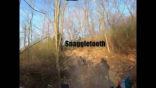
The trail is one of the flattest at Quarry Ridge. The grades are mostly mild, although there is one short, rocky uphill that can challenge even experienced riders. At slow speeds, the corners are easy and beginner-friendly. More advanced riders can hone their cornering skills at higher speeds through many berms, flat, and off-camber corners.
Local Trail Association
-
Capital Off Road Pathfinders
(www.madcitydirt.com) Please consider joining or donating to the local riding association to support trail development & maintenance.donate to earn trail karma!
More Stats for Dizzy bike trail
-
Altitude change8 ft
-
Altitude min974 ft
-
Altitude max1,007 ft
-
Altitude start974 ft
-
Altitude end983 ft
-
Grade0.158%
-
Grade max-10.745%
-
Grade min9.875%
-
Distance climb1,967 ft
-
Distance down2,362 ft
-
Distance flat907 ft
-
Avg time00:06:54
- view trail stats
close
Trail Conditions
- Unknown
- Snow Groomed
- Snow Packed
- Snow Covered
- Freeze/thaw Cycle
- Icy
- Prevalent Mud
- Wet
- Variable
- Dry
- Very Dry
Trail Ridden Direction
Trailforks scans users ridelogs to determine the most popular direction each trail is ridden. A good flowing trail network will have most trails flowing in a single direction according to their intension.
The colour categories are based on what percentage of riders are riding a trail in its intended direction.
- > 96%
- > 90%
- > 80%
- > 70%
- > 50%
- < 50%
Trail Last Ridden
Trailforks scans ridelogs to determine the last time a trail was ridden.
- < 2 days
- < 1 week
- < 2 weeks
- < 1 month
- < 6 months
- > 6 months
Trail Ridden Direction
The intendid direction a trail should be ridden.
- Downhill Only
- Downhill Primary
- Both Directions
- Uphill Primary
- Uphill Only
- One Direction
ContributeDetails
Colors indicate trail is missing specified detail.
- Description
- Photos
- Description & Photos
- Videos
LEGEND
Trail Difficulties
Trail Report Status
- Access Road/Trail
- White
- Green
- Blue
- Black
- Double Black Diamond
Trail Report Status
- Clear / Green
- Minor Issue / Yellow
- Significant Issue / Amber
- Closed or Major Issue / Red
- Land Owner Overlay
- Wilderness (typically no bikes in USA)
- BLM (public)
- USFS (Wildlife sanctuaries darker than usfs)
- State land
- Indigenous
- Military
Trail Conditions
- Unknown
- Snow Groomed
- Snow Packed
- Snow Covered
- Freeze/thaw Cycle
- Icy
- Prevalent Mud
- Wet
- Variable
- Dry
- Very Dry
- Map Markers
Trail Head
Photo
Directory Listing
Riding Area
TTF
Parking
Viewpoint
Information
Warning
Directions
Water Fountain/Source
Sight
Restrooms
Gate
Camping
Trail Sign
Table or Bench
eBike Charging Point
Other
Directions to dizzy trailhead
(43.003380, -89.481670)
update trails status or condition
Dizzy Trail Reports
view all reports »
Recent Ridelog Activity on Trail
Past Week
- 0 rides
6 Months
- 50 rides
- 11 miles avg distance
All
- 530 rides
Photos
no photos have been added for Dizzy yet, add a photo.
Routes with this trail
Reviews / Comments
No reviews yet, be the first to write a review or ask a question.
Use trail reports to comment on trail conditions.
Videos
no videos have been added for Dizzy yet, add a video.
Nearby Trails
- rewind 0 ft
- connector 7 ft
- tunnel trail 2,484 ft
- drop zone 2,585 ft
- bottoms up 2,864 ft
- embed Dizzy trail on your website
- By DReece CORP & contributors
- #43933 - 504 views
- subscribe
- login to download gpx or kml files.
Open trail in mobile app