Supporters, Builders, Maintainers & Land Managers of DM Trail
Cyclists of Gitchee Gumee ShoreMaintainer
DM Details
-
Activities
- Mountain Bike
- E-Bike
-
Riding AreaDuluth
, Minnesota -
Difficulty Rating
-
Voted DifficultyDouble Black Diamond (1 vote)
-
Trail TypeSingletrack
-
Bike TypeDH
-
DirectionDownhill PrimaryPopular direction shown
-
Climb DifficultyDouble Black Diamond
-
Physical RatingExtreme
-
Trail VisibilitySometimes hard to follow
-
Dogs AllowedYes
-
eBike Allowed
-
TTFs on TrailDrop, Rock Face
-
Global Ranking
-
Local Popularity85 in Mountain Biking [+]
- 80 in E-Biking
-
Land Owner
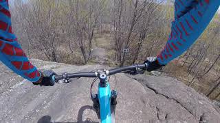
From the exposed rock dome at the top, head down to the southwest - watch for trail name signs, since there are a number of other runs starting near this same spot. The track begins with some generally steep wooded singletrack and a few rocky drops, before you come to the first of several very steep bedrock 'roll-downs' (depends on how you ride them). Notice that there is a short portion of the trail where you are sharing (riding on) Skyline, before leaving that trail again - keep your head up and watch for the sign. The first big bedrock decent is perhaps roughly 12' down. The subsequent big ones might be more like 15' from crest to bottom. As the track continues, several more steep drops are encountered. There is a short break in the decent about 3/4 of the way down, where you're crossing a flatter sort of plateau, as well as Skyline trail again, before the final short, but very gnarly rock-riddle
Local Trail Association
-
Please consider joining or donating to the local trail association to supportdonate to earn trail karma!
trail development & maintenance.
Traditionally Indigenous Territory
More Stats for DM mountain bike trail trail
-
Altitude change-190 ft
-
Altitude min1,080 ft
-
Altitude max1,270 ft
-
Altitude start1,270 ft
-
Altitude end1,079 ft
-
Grade-12.4%
-
Grade max-24.2%
-
Grade min-3.3%
-
Distance down1,522 ft
-
Avg time00:04:52
-
Avg reverse time00:17:32
- view trail stats
- Unknown
- Snow Groomed
- Snow Packed
- Snow Covered
- Snow Cover Partial
- Freeze/thaw Cycle
- Icy
- Prevalent Mud
- Wet
- Variable
- Ideal
- Dry
- Very Dry
The colour categories are based on what percentage of riders are riding a trail in its intended direction.
- > 96%
- > 90%
- > 80%
- > 70%
- > 50%
- < 50%
- bi-directional trail
- no data
- < 2 days
- < 1 week
- < 2 weeks
- < 1 month
- < 6 months
- > 6 months
- Downhill Only
- Downhill Primary
- Both Directions
- Uphill Primary
- Uphill Only
- One Direction
- Description
- Photos
- Description & Photos
- Videos
- most popular
- popular
- less popular
- not popular
- mountain biking recent
- mountain biking (>6 month)
- hiking (1 year)
- moto (1 year)
- Downhill Ski
- Backcountry Ski
- Nordic Ski
- Snowmobile
Save the current map location and zoom level as your default home location whenever this page is loaded.
SaveDM Trail Reports
Recent Ridelog Activity on Trail
- 3 rides
- 10 miles avg distance
- 11 rides
- 9 miles avg distance
- 197 rides
- Last: May 19, 2025
Photos
Routes with this trail
Trail Products
-
COGGS branded gearOther
3 Reviews & Comments
We hope you've been enjoying Trailforks!
Create a FREE account to view trail comments and much more.
Videos

Nearby Trails
- Medropolis 0 ft
- Nimby 0 ft
- Mejumpolis 0 ft
- Dr. Diablo 0 ft
- Bob (bones Of The Beast) 66 ft
- By namdoogttam
COGGS TRAILFORKS COGGS & contributors
- #26084 - 3,631 views
- follow/subscribe
- login to download gpx or kml files.
You must enter a description before submitting.