4,918 ft
Distance
56 ft
Climb
-322 ft
Descent
00:09:10
Avg time

Doctors Details

  • Activities
    • Mountain Bike
    • E-Bike
    • Hike
    • Trail Running
  • Riding Area
    Marquette NTN South Trails
    Marquette, Michigan
  • Difficulty Rating
  • Voted Difficulty
    Black Diamond (1 vote)
  • Trail Type
    Singletrack
  • Bike Type
    DH, AM, XC
  • Direction
    Downhill Only
    Popular direction shown
  • Dogs Allowed
    Yes
  • eBike Allowed
  • TTFs on Trail
    Rock Garden
  • Global Ranking
    #5202 in Mountain Biking [+]
    • #5015 in Trail Running
    • #52664 in Hiking
  • Local Popularity
    75 in Mountain Biking [+]
    • 70 in E-Biking
    • 80 in Trail Running
    • 80 in Hiking
  • Land Owner
    Noquemanon Trail Network

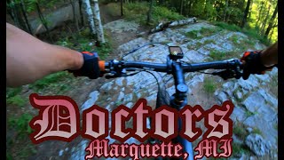
After climbing Gurley and crossing Mount Marquette Road, Doctors is your first option of descent. The trail starts relatively flat and slowly becomes steepens as you go. Once the trail gets going downhill the ability to blast through rocks and root at high speeds makes this trail very fun to ride. At the end of the trail a small rock slab and a steep roll down over some roots rounds out the trail.

Local Trail Association
More Stats for Doctors mountain bike trail trail
  • Altitude change
    -266 ft
  • Altitude min
    735 ft
  • Altitude max
    1,024 ft
  • Altitude start
    1,000 ft
  • Altitude end
    735 ft
  • Grade
    -5.4%
  • Grade max
    -32.1%
  • Grade min
    12.3%
  • Distance climb
    801 ft
  • Distance down
    3,133 ft
  • Distance flat
    984 ft
  • Avg time
    00:09:10
  • Avg reverse time
    00:12:15
  • view trail stats
Status:
on Aug 11, 2024
Ideal
Avg: 4.35 (11 votes)
Your vote: 0

view (2,891)
close
3D
Trail Conditions
  • Unknown
  • Snow Groomed
  • Snow Packed
  • Snow Covered
  • Snow Cover Partial
  • Freeze/thaw Cycle
  • Icy
  • Prevalent Mud
  • Wet
  • Variable
  • Ideal
  • Dry
  • Very Dry
Trail Flow (Ridden Direction)
Trailforks scans users ridelogs to determine the most popular direction each trail is ridden. A good flowing trail network will have most trails flowing in a single direction according to their intension.
The colour categories are based on what percentage of riders are riding a trail in its intended direction.
  • > 96%
  • > 90%
  • > 80%
  • > 70%
  • > 50%
  • < 50%
  • bi-directional trail
  • no data
Trail Last Ridden
Trailforks scans ridelogs to determine the last time a trail was ridden.
  • < 2 days
  • < 1 week
  • < 2 weeks
  • < 1 month
  • < 6 months
  • > 6 months
Trail Ridden Direction
The intended direction a trail should be ridden.
  • Downhill Only
  • Downhill Primary
  • Both Directions
  • Uphill Primary
  • Uphill Only
  • One Direction
Contribute Details
Colors indicate trail is missing specified detail.
  • Description
  • Photos
  • Description & Photos
  • Videos
Trail Popularity ?
Trailforks scans ridelogs to determine which trails are ridden the most in the last 9 months. Trails are compared with nearby trails in the same city region with a possible 25 colour shades. Think of this as a heatmap, more rides = more kinetic energy = warmer colors.
  • most popular
  • popular
  • less popular
  • not popular
ATV/ORV/OHV Filter
Max Vehicle Width
inches
US Cell Coverage
Legend
cell carrier legend

Radar Time
x Activity Recordings
Trailforks users anonymized public ridelogs from the past 6 months.
  • mountain biking recent
  • mountain biking (>6 month)
  • hiking (1 year)
  • moto (1 year)
Activity Recordings
Trailforks users anonymized public skilogs from the past 12 months.
  • Downhill Ski
  • Backcountry Ski
  • Nordic Ski
  • Snowmobile
Winter Trails
Warning A routing network for winter maps does not exist. Selecting trails using the winter trails layer has been disabled.
x Missing Trails
Most Popular
Least Popular
Trails are colored based on popularity. The more popular a trail is, the more red. Less popular trails trend towards green.
Jump Magnitude Heatmap
Heatmap of where riders jump on trails. Zoom in to see individual jumps, click circles to view jump details.
Trails Deemphasized
Trails are shown in grey.
disable
Only show trails with NO bikes.
enable

Save the current map location and zoom level as your default home location whenever this page is loaded.

Save
      Directions to doctors trailhead (46.512960, -87.406560)
      update trails status or condition

      Doctors Trail Reports

      statusdatedescription
      Aug 11, 2024 @ 2:04am
      Aug 11, 2024
      Jun 30, 2024 @ 9:27am
      Jun 30, 2024
      Jun 27, 2024 @ 6:02am
      Jun 27, 2024
      Lots of washout, use your mountain bike and shocks for what they were intended for.
      Aug 30, 2023 @ 8:00am
      Aug 30, 2023
      Doctors drop ride around
      Jul 5, 2023 @ 9:12am
      Jul 5, 2023
      view all reports »

      Recent Ridelog Activity on Trail

      Past Week
      • 0 rides
      •  
      6 Months
      • 8 rides
      • 11 miles avg distance
      All
      • 288 rides
      • Last: Mar 25, 2025

      Photos

      more »
      199 |
      Oct 6, 2018 @ 7:43pm
      Oct 6, 2018
      355 |
      Oct 6, 2018 @ 7:43pm
      Oct 6, 2018
      477 |
      Apr 11, 2010 @ 10:34pm
      Apr 11, 2010
      948 |
      Apr 12, 2010 @ 7:59am
      Apr 12, 2010

      Routes with this trail

      more »
      titledistance
      Marji 2021 100mi Route V3.9.gpx105 miles
      2024 Long XC23 miles
      Marji Gesick 2022 100mile Course106 miles
      2020 MTR virt race short 54 miles

      2 Reviews & Comments


      We hope you've been enjoying Trailforks!

      Create a FREE account to view trail comments and much more.

      Videos

      more »
      youtuber There's a Reason It's Called Doctors •...
      10:37 | 634 | Oct 10, 2019 , Marquette
      Doctors
      5:10 | 367 | Jun 5, 2022 , Marquette
      1st ride on 'Doctors' mountain bike trail in...
      4:34 | 152 | Feb 22, 2022 , Marquette
      LEAVE IT ALL OUT THERE! 10th Anniversary Finale
      19:55 | 152 | Jul 22, 2021 , Marquette

      You must enter a description before submitting.