4,551 ft
Distance
-705 ft
Descent
00:11:09
Avg time

Double Down Details

  • Activities
    • Mountain Bike
    • E-Bike
    • Hike
    • Trail Running
  • Riding Area
    Chuckanut Mountain
    Bellingham, Washington
  • Difficulty Rating
  • Voted Difficulty
    Black Diamond (2 votes)
  • Trail Type
    Singletrack
  • Direction
    Downhill Only
    Popular direction shown
  • Dogs Allowed
    Yes
  • eBike Allowed
    Yes up to Class 1
  • TTFs on Trail
    Drop, Jump
  • Global Ranking
    #353 in Mountain Biking [+]
    • #5259 in E-Biking
    • #24020 in Trail Running
    • #31802 in Hiking
  • Local Popularity
    95 in Mountain Biking [+]
    • 100 in E-Biking
    • 40 in Trail Running
    • 70 in Hiking

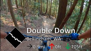
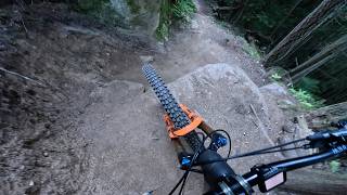
Continue off double black to the bottom of the mountain. This is a twisty and technical trail with roots and a few natural rock drops. There's a portion with mild ravine exposure. It's a lot of fun for the adventurous rider seeking some excitement without an epic climb. There's plenty of gnar, a great bouncy rhythm and loads of cheap thrills along the way.

Local Trail Association
Traditionally Indigenous Territory
More Stats for Double Down mountain bike trail trail
  • Altitude change
    -705 ft
  • Altitude min
    248 ft
  • Altitude max
    953 ft
  • Altitude start
    953 ft
  • Altitude end
    249 ft
  • Grade
    -15.5%
  • Grade max
    -48.6%
  • Grade min
    -2%
  • Distance down
    4,551 ft
  • Avg time
    00:11:09
  • Avg reverse time
    00:21:34
  • view trail stats
Status:
on Mar 19, 2023
Variable
Avg: 4.8 (66 votes)
Your vote: 0

view (8,715)
close
3D
Trail Conditions
  • Unknown
  • Snow Groomed
  • Snow Packed
  • Snow Covered
  • Snow Cover Inadequate
  • Freeze/thaw Cycle
  • Icy
  • Prevalent Mud
  • Wet
  • Variable
  • Ideal
  • Dry
  • Very Dry
Trail Flow (Ridden Direction)
Trailforks scans users ridelogs to determine the most popular direction each trail is ridden. A good flowing trail network will have most trails flowing in a single direction according to their intension.
The colour categories are based on what percentage of riders are riding a trail in its intended direction.
  • > 96%
  • > 90%
  • > 80%
  • > 70%
  • > 50%
  • < 50%
  • bi-directional trail
  • no data
Trail Last Ridden
Trailforks scans ridelogs to determine the last time a trail was ridden.
  • < 2 days
  • < 1 week
  • < 2 weeks
  • < 1 month
  • < 6 months
  • > 6 months
Trail Ridden Direction
The intended direction a trail should be ridden.
  • Downhill Only
  • Downhill Primary
  • Both Directions
  • Uphill Primary
  • Uphill Only
  • One Direction
Contribute Details
Colors indicate trail is missing specified detail.
  • Description
  • Photos
  • Description & Photos
  • Videos
Trail Popularity ?
Trailforks scans ridelogs to determine which trails are ridden the most in the last 9 months. Trails are compared with nearby trails in the same city region with a possible 25 colour shades. Think of this as a heatmap, more rides = more kinetic energy = warmer colors.
  • most popular
  • popular
  • less popular
  • not popular
ATV/ORV/OHV Filter
Max Vehicle Width
inches

Radar Time
x Activity Recordings
Trailforks users anonymized public ridelogs from the past 6 months.
  • mountain biking recent
  • mountain biking (>6 month)
  • hiking (1 year)
  • moto (1 year)
Activity Recordings
Trailforks users anonymized public skilogs from the past 12 months.
  • Downhill Ski
  • Backcountry Ski
  • Nordic Ski
  • Snowmobile
Jump Magnitude Heatmap
Heatmap of where riders jump on trails. Zoom in to see individual jumps, click circles to view jump details.
Trails Deemphasized
Trails are shown in grey.
disable
Only show trails with NO bikes.
enable

Save the current map location and zoom level as your default home location whenever this page is loaded.

Save
      Directions to double-down-39330 trailhead (48.654020, -122.479480)
      update trails status or condition

      Double Down Trail Reports

      statusdatedescription
      Mar 19, 2023 @ 1:17am
      Mar 19, 2023
      Just spots of mud, wet rock, or damp roots. Awesome view at the top. [L=https://www.evergreenmtb.org/trails/ride-reports/rr-7586]EvergreenMTB...
      Feb 11, 2023 @ 8:18pm
      Feb 11, 2023
      All clear
      Dec 26, 2022 @ 12:26pm
      Dec 26, 2022
      Some greaser spots from freeze-thaw. Large trees down in 2 sections near the first 1/3 of the trail. Still riding great.
      Dec 2, 2022 @ 4:18pm
      Dec 2, 2022
      Big tree fall and trail damage about 1/3 of the way down
      Nov 12, 2022 @ 7:25pm
      Nov 12, 2022
      view all reports »

      Recent Ridelog Activity on Trail

      Past Week
      • 23 rides
      • 10 miles avg distance
      6 Months
      • 391 rides
      • 10 miles avg distance
      All
      • 7,226 rides
      • Last: Apr 1, 2023

      Photos

      more »
      27 |
      Dec 4, 2022 @ 4:17pm
      Dec 4, 2022
      188 |
      Sep 14, 2020 @ 7:20pm
      Sep 14, 2020
      1,019 |
      Nov 11, 2017 @ 8:30am
      Nov 11, 2017
      1,059 |
      Nov 11, 2017 @ 8:30am
      Nov 11, 2017

      Routes with this trail

      more »
      titledistance
      Double Black, Double Down6 miles
      Freehub Magazine: Double Black Diamond to Double Down2 miles
      Big Chuckanut Ride15 miles
      GLC56 miles

      7 Reviews & Comments


      We hope you've been enjoying Trailforks!

      Create a FREE account to view trail comments and much more.

      Videos

      more »
      youtuber Best Trail In Bellingham? (Chuckanuts)
      11:37 | 624 | Jan 10, 2021 , Bellingham
      youtuber Once I got that HD5 dialed in...
      9:42 | 660 | Dec 26, 2019 , Bellingham
      Double Down | Mountain Bike Chuckanut Mountain, WA
      5:11 | 200 | Jul 17, 2022 , Bellingham
      Tour De Bellingham| Hitting Bellingham's Best...
      21:34 | 84 | May 27, 2022 , Bellingham
      • subscribe
      • flag
      • login to download gpx or kml files.