more stats
3,353 ft
Distance
140 ft
Climb
-27 ft
Descent
00:10:03
Avg time
113 ft
Altitude change
433 ft
Altitude min
552 ft
Altitude max
433 ft
Altitude start
545 ft
Altitude end
3.4%
Grade
-11.8%
Grade max
15.2%
Grade min
1,749 ft
Distance climb
541 ft
Distance down
1,037 ft
Distance flat
00:10:03
Avg time

Doughboy Details

  • Activities
    • Mountain Bike
    • Gravel Bike
    • Hike
    • Trail Running
  • Riding Area
    Standing Boy Trails
    Columbus, Georgia
  • Difficulty Rating
  • Local Popularity
    95 in Mountain Biking [+]
    • 5 in Trail Running
    • 75 in Hiking
  • Global Ranking
    #123803 in Mountain Biking
  • Hiking SAC Scale
    T1 Hiking
  • Trail Type
    Singletrack
  • Bike Type
    AM, XC, CX, Gravel
  • Direction
    Both Directions
    Popular Direction Shown
  • Trail Visibility
    Always easy to follow
  • Season
    All Year
  • Dogs Allowed
    Yes
  • Year Opened
    2020
  • Land Owner
    DNR

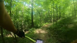
Doughboy is a multi-directional trail that is primarily used to get to The Bug which starts at the top. The trail is wide and relatively smooth with a gradual gradient.

Access Info

Take a left onto the first gravel road off of Old River Road and there will be a gravel parking lot on the right where the trail starts. Do not park on Old River Road. Doughboy starts at the end of Primary Goods.

Disclaimer

You must have a GA State Parks ParkPass, annual or daily.

Trail Supporters
Traditionally Indigenous Territory

Recent Activity on Trail

Past Week
  • 2 rides
  • 58 miles average
6 Months
  • 30 rides
  • 16 miles avg distance
All
  • 323 rides
  • Last: Jun 30, 2026
c1c2c3c4
January
February
March
April
May
June
July
August
September
October
November
December
Status:
on Sep 30, 2025
Ideal
Avg: 3.84 (2 votes)
Your vote: 0

view (2,067)
close
3D
Trail Conditions
  • Unknown
  • Snow Groomed
  • Snow Packed
  • Snow Covered
  • Snow Cover Partial
  • Freeze/thaw Cycle
  • Icy
  • Prevalent Mud
  • Wet
  • Variable
  • Ideal
  • Dry
  • Very Dry
Trail Flow (Ridden Direction)
Trailforks scans users ridelogs to determine the most popular direction each trail is ridden. A good flowing trail network will have most trails flowing in a single direction according to their intension.
The colour categories are based on what percentage of riders are riding a trail in its intended direction.
  • > 96%
  • > 90%
  • > 80%
  • > 70%
  • > 50%
  • < 50%
  • bi-directional trail
  • no data
Trail Last Ridden
Trailforks scans ridelogs to determine the last time a trail was ridden.
  • < 2 days
  • < 1 week
  • < 2 weeks
  • < 1 month
  • < 6 months
  • > 6 months
Trail Ridden Direction
The intended direction a trail should be ridden.
  • Downhill Only
  • Downhill Primary
  • Both Directions
  • Uphill Primary
  • Uphill Only
  • One Direction
Contribute Details
Colors indicate trail is missing specified detail.
  • Description
  • Photos
  • Description & Photos
  • Videos
Trail Popularity ?
Trailforks scans ridelogs to determine which trails are ridden the most in the last 9 months. Trails are compared with nearby trails in the same city region with a possible 25 colour shades. Think of this as a heatmap, more rides = more kinetic energy = warmer colors.
  • most popular
  • popular
  • less popular
  • not popular
ATV/ORV/OHV Filter
Max Vehicle Width
inches
US Cell Coverage
Legend
cell carrier legend

Radar Time
Activity Recordings
Trailforks uses anonymized public activity data. ?
Activity Recordings
Trailforks uses anonymized public activity data. ?
Personal Heatmap
Activity Types
all / none
Options
2
Date range month
Winter Trails
Warning A routing network for winter maps does not exist. Selecting trails using the winter trails layer has been disabled.
Missing Trails
Most Popular
Least Popular
Trails are colored based on popularity. The more popular a trail is, the more red. Less popular trails trend towards green.
Jump Magnitude Heatmap
Heatmap of where riders jump on trails. Zoom in to see individual jumps, click circles to view jump details.
BC Backroad Status

Service Road Atlas is a free to use, community-driven service for viewing and creating reports on the numerous back-country service roads around B.C. and Alberta.

map legend
Slope Aspect
Direction the slope faces
Flat N NE E SE S SW W NW
Trails Deemphasized
Trails are shown in grey.
disable
Only show trails with no bike usage.
Enable
Suggested Layers
Based on selected activity type

    Save the current map location and zoom level as your default home location whenever this page is loaded.

    Save
        Directions to doughboy trailhead (32.580350, -85.038730)

        Photos

        1 more »
        86 |
        Sep 24, 2022 @ 2:01pm
        Sep 24, 2022

        Videos

        1 more »
        POV - Doughboy - Standing Boy Trails -...
        6:06 | 522 | Jul 12, 2021 , Columbus

        Routes with this trail

        6 miles 674 ft 4 Loop
        The Green Loop is the a beginner friendly loop that has flowy sections of trails along and , then a...
        7 miles 655 ft 4 Loop Race
        GA Police and Fire Games 2023 MTB race route (beginner)

        1 Review & Comments


        We hope you've been enjoying Trailforks!

        Create a FREE account to view trail comments and much more.

        • By williedTF Pro CVA SORBA & contributors
        • #309440 - 719 views

        Frequently Asked Questions About Doughboy

        Where is Doughboy located?
        Doughboy is located in Standing Boy Trails, Columbus, Georgia, United States. It is part of the Standing Boy Trails trail network. The trailhead is located at coordinates 32.58035, -85.03873.
        How hard is Doughboy?
        Doughboy is rated as Green difficulty. The average grade is 3.4%.
        What is the elevation gain for Doughboy?
        Doughboy has 140 ft of elevation gain. The trail has 27 ft of elevation descent. The elevation ranges from 433 ft to 552 ft.
        Is Doughboy a point to point trail?
        Doughboy is not a point to point trail. The direction is Both Directions. The trail type is singletrack.

        Hit the Trail

        Open in App

        Get this trail on your phone instantly.
        open trail in app

        Download Trail

        Save to wishlist, Garmin & download.
        save the trail

        Find Related Routes

        Find routes and users activities that include this trail.
        find routes for this trail

        You must enter a description before submitting.