more stats
5,249 ft
Distance
61 ft
Climb
-220 ft
Descent
00:08:32
Avg time
-157 ft
Altitude change
388 ft
Altitude min
555 ft
Altitude max
551 ft
Altitude start
394 ft
Altitude end
-3%
Grade
-22.6%
Grade max
16%
Grade min
1,040 ft
Distance climb
3,100 ft
Distance down
1,109 ft
Distance flat
00:08:32
Avg time

The Bug Details

  • Activities
    • Mountain Bike
  • Riding Area
    Standing Boy Trails
    Columbus, Georgia
  • AKA
    Green Gravity
  • Difficulty Rating
  • Local Popularity
    95 in Mountain Biking
  • Global Ranking
    #122744 in Mountain Biking
  • Trail Type
    Singletrack
  • Bike Type
    AM, XC
  • Direction
    Downhill Only
    Popular Direction Shown
  • Climb Difficulty
    Green
  • Physical Rating
    Moderate
  • Trail Visibility
    Always easy to follow
  • Season
    All Year
  • Dogs Allowed
    Yes
  • TTFs on Trail
    Berm, Jump
  • Year Opened
    2020
  • Land Owner
    DNR

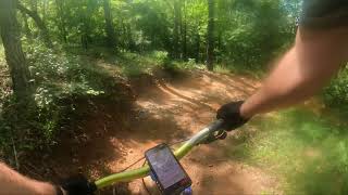
The Bug is a mostly gentle rolling descent with berms, rollers, and some mellow jumps. Downhill only.

Access Info

To access the trail you can ride Primary Goods until it meets up with Bimini and Doughboy. Take a hard left at that junction and start climbing on Doughboy. The trail ends back at the parking lot.

Disclaimer

You must have a GA State Parks ParkPass, annual or daily.

Trail Supporters
Traditionally Indigenous Territory

Recent Activity on Trail

Past Week
  • 0 rides
  •  
6 Months
  • 36 rides
  • 15 miles avg distance
All
  • 291 rides
  • Last: Jun 24, 2026
c1c2c3c4
January
February
March
April
May
June
July
August
September
October
November
December
update trails status or condition

The Bug Trail Reports

statusdatedescription
Sep 5, 2025 @ 10:25am
Sep 5, 2025
Jul 17, 2025 @ 8:21am
Jul 17, 2025
Feb 24, 2025 @ 6:05pm
Feb 24, 2025
Aug 17, 2024 @ 1:54pm
Aug 17, 2024
May 24, 2024 @ 6:28am
May 24, 2024
Trails mostly dry. There are just a few places on the trail that are a bit muddy.
more »
Status:
on Sep 5, 2025
Wet
Avg: 4.24 (2 votes)
Your vote: 0

view (1,896)
close
3D
Trail Conditions
  • Unknown
  • Snow Groomed
  • Snow Packed
  • Snow Covered
  • Snow Cover Partial
  • Freeze/thaw Cycle
  • Icy
  • Prevalent Mud
  • Wet
  • Variable
  • Ideal
  • Dry
  • Very Dry
Trail Flow (Ridden Direction)
Trailforks scans users ridelogs to determine the most popular direction each trail is ridden. A good flowing trail network will have most trails flowing in a single direction according to their intension.
The colour categories are based on what percentage of riders are riding a trail in its intended direction.
  • > 96%
  • > 90%
  • > 80%
  • > 70%
  • > 50%
  • < 50%
  • bi-directional trail
  • no data
Trail Last Ridden
Trailforks scans ridelogs to determine the last time a trail was ridden.
  • < 2 days
  • < 1 week
  • < 2 weeks
  • < 1 month
  • < 6 months
  • > 6 months
Trail Ridden Direction
The intended direction a trail should be ridden.
  • Downhill Only
  • Downhill Primary
  • Both Directions
  • Uphill Primary
  • Uphill Only
  • One Direction
Contribute Details
Colors indicate trail is missing specified detail.
  • Description
  • Photos
  • Description & Photos
  • Videos
Trail Popularity ?
Trailforks scans ridelogs to determine which trails are ridden the most in the last 9 months. Trails are compared with nearby trails in the same city region with a possible 25 colour shades. Think of this as a heatmap, more rides = more kinetic energy = warmer colors.
  • most popular
  • popular
  • less popular
  • not popular
ATV/ORV/OHV Filter
Max Vehicle Width
inches
US Cell Coverage
Legend
cell carrier legend

Radar Time
Activity Recordings
Trailforks uses anonymized public activity data. ?
Activity Recordings
Trailforks uses anonymized public activity data. ?
Personal Heatmap
Activity Types
all / none
Options
2
Date range month
Winter Trails
Warning A routing network for winter maps does not exist. Selecting trails using the winter trails layer has been disabled.
Missing Trails
Most Popular
Least Popular
Trails are colored based on popularity. The more popular a trail is, the more red. Less popular trails trend towards green.
Jump Magnitude Heatmap
Heatmap of where riders jump on trails. Zoom in to see individual jumps, click circles to view jump details.
BC Backroad Status

Service Road Atlas is a free to use, community-driven service for viewing and creating reports on the numerous back-country service roads around B.C. and Alberta.

map legend
Slope Aspect
Direction the slope faces
Flat N NE E SE S SW W NW
Trails Deemphasized
Trails are shown in grey.
disable
Only show trails with no bike usage.
Enable
Suggested Layers
Based on selected activity type

    Save the current map location and zoom level as your default home location whenever this page is loaded.

    Save
        Directions to the-bug trailhead (32.577720, -85.036000)

        Photos

        5 more »
        79 |
        Jan 3, 2024 @ 8:58am
        Jan 3, 2024
        104 |
        Sep 17, 2022 @ 1:21pm
        Sep 17, 2022
        110 |
        Oct 2, 2020 @ 2:58pm
        Oct 2, 2020
        104 |
        Oct 2, 2020 @ 2:55pm
        Oct 2, 2020

        Videos

        3 more »
        Standing Boy - Tom Brown Two State Mountain...
        15:44 | 64 | May 26, 2025 , Columbus
        1.2 miles of beginner Mtb happiness
        4:49 | 115 | Jul 18, 2024 , Columbus
        POV - The Bug - Standing Boy Trails - Fortson,...
        5:07 | 404 | Jul 12, 2021 , Columbus

        Routes with this trail

        6 miles 674 ft 4 Loop
        The Green Loop is the a beginner friendly loop that has flowy sections of trails along and , then a...
        7 miles 655 ft 4 Loop Race
        GA Police and Fire Games 2023 MTB race route (beginner)

        2 Reviews & Comments


        We hope you've been enjoying Trailforks!

        Create a FREE account to view trail comments and much more.

        • By williedTF Pro CVA SORBA & contributors
        • #290614 - 1,148 views

        Frequently Asked Questions About The Bug

        Where is The Bug located?
        The Bug is located in Standing Boy Trails, Columbus, Georgia, United States. It is part of the Standing Boy Trails trail network. The trailhead is located at coordinates 32.57772, -85.036.
        How hard is The Bug?
        The Bug is rated as Green difficulty. The physical rating is Moderate. The average grade is 3%. The climb difficulty is rated Green.
        What is the elevation gain for The Bug?
        The Bug has 61 ft of elevation gain. The trail has 220 ft of elevation descent. The elevation ranges from 388 ft to 555 ft.
        Is The Bug a point to point trail?
        Yes, The Bug is a point to point trail. The direction is Downhill Only. The trail type is singletrack.

        Hit the Trail

        Open in App

        Get this trail on your phone instantly.
        open trail in app

        Download Trail

        Save to wishlist, Garmin & download.
        save the trail

        Find Related Routes

        Find routes and users activities that include this trail.
        find routes for this trail

        You must enter a description before submitting.