more stats
1,352 ft
Distance
-134 ft
Descent
00:03:58
Avg time
-134 ft
Altitude change
711 ft
Altitude min
844 ft
Altitude max
844 ft
Altitude start
712 ft
Altitude end
-9.9%
Grade
-27.1%
Grade max
1,198 ft
Distance down
151 ft
Distance flat
00:03:58
Avg time

Duee Details

  • Activities
    • Mountain Bike
    • E-Bike
  • Riding Area
  • AKA
    דואי , סינגל דואי , Single Du-E
  • Difficulty Rating
  • Local Popularity
    90 in Mountain Biking [+]
    • 90 in E-Biking
  • Global Ranking
    #70410 in Mountain Biking [+]
    • #24584 in E-Biking
  • Trail Type
    Singletrack
  • Bike Type
    AM
  • Direction
    Downhill Only
    Popular Direction Shown
  • Physical Rating
    Moderate
  • Trail Visibility
    Always easy to follow
  • Dogs Allowed
    Yes
  • eBike Allowed
    Yes up to Class 1
  • TTFs on Trail
    Berm, Drop, Jump, Rock Garden
  • Year Opened
    2015

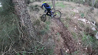
Single Du-E is a 400 meters downhill single track that can used as part of a ride in the area of Lachish or as a short trail for practicing downhill/agressive all mountain techniques (if you do there a couple of runs) . This single track is short but gives the rider a lot of fun , at the end of the single track there is a local hummus resturant .
Extreamly recommended ! Have fun !!.
**Be careful at the last steep section and slow down because of the single track ends after this section and you will be close to a road!

Access Info

You arrive to Moshav Lachish (מושב לכיש) , after the main yellow gate of moshav lachish there is traffic circle , you take the first exit(right) then you take the right turn , continue straight until you see a green gate , take the left turn that takes you off the road , after that , continue straight in the split -(left turn/straight/right turn) (to the direction of the forest) continue straight until there will be a right turn , take this right turn to enter the forest , you can park there your car if you want , continue straight(10-15 meters)- turn left into the forest and contiue straight(20-30 meters) until you see the single track from the right side . Enter the single track and have fun

Recent Activity on Trail

Past Week
  • 0 rides
  •  
6 Months
  • 2 rides
  • 15.6 km avg distance
All
  • 9 rides
  • Last: Jan 17, 2026
c1c2c3c4
January
February
March
April
May
June
July
August
September
October
November
December
update trails status or condition

Duee Trail Reports

statusdatedescription
Jan 18, 2026 @ 11:12pm (Asia/Jerusalem)
Jan 18, 2026
due winter grass its hard to find the starting point
Jul 1, 2021 @ 8:05pm
Jul 1, 2021
Dec 18, 2020 @ 9:08pm
Dec 18, 2020
The trail is clear
Sep 20, 2020 @ 1:45am
Sep 20, 2020
Fallen trees have blocked the trail unfortunately.
Nov 30, 2019 @ 11:22am
Nov 30, 2019
Ideal Conditions ! So much fun :)
more »
Status:
on Jan 18, 2026
Variable
Avg: 3.74 (2 votes)
Your vote: 0

view (271)
close
3D
Trail Conditions
  • Unknown
  • Snow Groomed
  • Snow Packed
  • Snow Covered
  • Snow Cover Partial
  • Freeze/thaw Cycle
  • Icy
  • Prevalent Mud
  • Wet
  • Variable
  • Ideal
  • Dry
  • Very Dry
Trail Flow (Ridden Direction)
Trailforks scans users ridelogs to determine the most popular direction each trail is ridden. A good flowing trail network will have most trails flowing in a single direction according to their intension.
The colour categories are based on what percentage of riders are riding a trail in its intended direction.
  • > 96%
  • > 90%
  • > 80%
  • > 70%
  • > 50%
  • < 50%
  • bi-directional trail
  • no data
Trail Last Ridden
Trailforks scans ridelogs to determine the last time a trail was ridden.
  • < 2 days
  • < 1 week
  • < 2 weeks
  • < 1 month
  • < 6 months
  • > 6 months
Trail Ridden Direction
The intended direction a trail should be ridden.
  • Downhill Only
  • Downhill Primary
  • Both Directions
  • Uphill Primary
  • Uphill Only
  • One Direction
Contribute Details
Colors indicate trail is missing specified detail.
  • Description
  • Photos
  • Description & Photos
  • Videos
Trail Popularity ?
Trailforks scans ridelogs to determine which trails are ridden the most in the last 9 months. Trails are compared with nearby trails in the same city region with a possible 25 colour shades. Think of this as a heatmap, more rides = more kinetic energy = warmer colors.
  • most popular
  • popular
  • less popular
  • not popular
ATV/ORV/OHV Filter
Max Vehicle Width
inches
US Cell Coverage
Legend
cell carrier legend

Radar Time
Activity Recordings
Trailforks uses anonymized public activity data. ?
Activity Recordings
Trailforks uses anonymized public activity data. ?
Personal Heatmap
Activity Types
all / none
Options
2
Date range month
Winter Trails
Warning A routing network for winter maps does not exist. Selecting trails using the winter trails layer has been disabled.
Missing Trails
Most Popular
Least Popular
Trails are colored based on popularity. The more popular a trail is, the more red. Less popular trails trend towards green.
Jump Magnitude Heatmap
Heatmap of where riders jump on trails. Zoom in to see individual jumps, click circles to view jump details.
BC Backroad Status

Service Road Atlas is a free to use, community-driven service for viewing and creating reports on the numerous back-country service roads around B.C. and Alberta.

map legend
Slope Aspect
Direction the slope faces
Flat N NE E SE S SW W NW
Trails Deemphasized
Trails are shown in grey.
disable
Only show trails with no bike usage.
Enable
Suggested Layers
Based on selected activity type

    Save the current map location and zoom level as your default home location whenever this page is loaded.

    Save
        Directions to duee trailhead (31.572930, 34.844840)

        Photos

        8 more »
        178 |
        May 26, 2023 @ 11:29pm
        May 26, 2023
        223 |
        May 26, 2023 @ 11:29pm
        May 26, 2023
        192 |
        May 26, 2023 @ 11:29pm
        May 26, 2023
        158 |
        May 26, 2023 @ 11:26pm
        May 26, 2023

        Videos

        1 more »
        CRASH!
        0:08 | 547 | Jan 4, 2020 , My City

        2 Reviews & Comments


        We hope you've been enjoying Trailforks!

        Create a FREE account to view trail comments and much more.

        Nearby Trails

        • By pozitivi & contributors
        • #52042 - 2,254 views

        Frequently Asked Questions About Duee

        Where is Duee located?
        Duee is located in Lachish, Israel. It is part of the Lachish trail network. The trailhead is located at coordinates 31.57293, 34.84484.
        How hard is Duee?
        Duee is rated as Red difficulty. The physical rating is Moderate. The average grade is 9.9%.
        What is the elevation gain for Duee?
        The trail has 134 ft of elevation descent. The elevation ranges from 711 ft to 844 ft.
        Is Duee a point to point trail?
        Yes, Duee is a point to point trail. The direction is Downhill Only. The trail type is singletrack.

        Hit the Trail

        Open in App

        Get this trail on your phone instantly.
        open trail in app

        Download Trail

        Save to wishlist, Garmin & download.
        save the trail

        Find Related Routes

        Find routes and users activities that include this trail.
        find routes for this trail

        You must enter a description before submitting.