1.4 miles
Distance
54 ft
Climb
-634 ft
Descent
00:08:22
Avg time
Supporters, Builders, Maintainers & Land Managers of Easy Ryder Trail

Easy Ryder Details

  • Activities
    • Mountain Bike
    • E-Bike
  • Riding Area
  • Difficulty Rating
  • Trail Type
    Machine Groomed
  • Bike Type
    AM
  • Trail Visibility
    Always easy to follow
  • Dogs Allowed
    Yes
  • eBike Allowed
    Yes up to Class 1
  • TTFs on Trail
    Berm, Bridge
  • Local Popularity
    95 in Mountain Biking [+]
    • 95 in E-Biking
  • Year Opened
    2023
  • Land Owner
    Niseko Area Mountain Bike Association

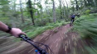
Easy Ryder is a 2 km popular blue machine groomed trail located near Niseko. Upper section has more single track feel to it while the low section is full of nice flowing berms, rollers and a few jumps that can be rolled. Lower section near Easy Ryder link 2 has a optional 5 to 6m gap jump that has a roll around beside it

More Stats for Easy Ryder mountain bike trail trail
  • Altitude change
    -580 ft
  • Altitude min
    835 ft
  • Altitude max
    1,420 ft
  • Altitude start
    1,415 ft
  • Altitude end
    837 ft
  • Grade
    -8.1%
  • Grade max
    -115.2%
  • Grade min
    15%
  • Distance climb
    899 ft
  • Distance down
    5,203 ft
  • Distance flat
    1,070 ft
  • Avg time
    00:08:22
  • view trail stats
Status:
on Jul 10, 2025
Ideal
Avg: 4.35 (5 votes)
Your vote: 0

view (259)
close
3D
Trail Conditions
  • Unknown
  • Snow Groomed
  • Snow Packed
  • Snow Covered
  • Snow Cover Partial
  • Freeze/thaw Cycle
  • Icy
  • Prevalent Mud
  • Wet
  • Variable
  • Ideal
  • Dry
  • Very Dry
Trail Flow (Ridden Direction)
Trailforks scans users ridelogs to determine the most popular direction each trail is ridden. A good flowing trail network will have most trails flowing in a single direction according to their intension.
The colour categories are based on what percentage of riders are riding a trail in its intended direction.
  • > 96%
  • > 90%
  • > 80%
  • > 70%
  • > 50%
  • < 50%
  • bi-directional trail
  • no data
Trail Last Ridden
Trailforks scans ridelogs to determine the last time a trail was ridden.
  • < 2 days
  • < 1 week
  • < 2 weeks
  • < 1 month
  • < 6 months
  • > 6 months
Trail Ridden Direction
The intended direction a trail should be ridden.
  • Downhill Only
  • Downhill Primary
  • Both Directions
  • Uphill Primary
  • Uphill Only
  • One Direction
Contribute Details
Colors indicate trail is missing specified detail.
  • Description
  • Photos
  • Description & Photos
  • Videos
Trail Popularity ?
Trailforks scans ridelogs to determine which trails are ridden the most in the last 9 months. Trails are compared with nearby trails in the same city region with a possible 25 colour shades. Think of this as a heatmap, more rides = more kinetic energy = warmer colors.
  • most popular
  • popular
  • less popular
  • not popular
ATV/ORV/OHV Filter
Max Vehicle Width
inches
US Cell Coverage
Legend
cell carrier legend

Radar Time
x Activity Recordings
Trailforks users anonymized public ridelogs from the past 6 months.
  • mountain biking recent
  • mountain biking (>6 month)
  • hiking (1 year)
  • moto (1 year)
Activity Recordings
Trailforks users anonymized public skilogs from the past 12 months.
  • Downhill Ski
  • Backcountry Ski
  • Nordic Ski
  • Snowmobile
Winter Trails
Warning A routing network for winter maps does not exist. Selecting trails using the winter trails layer has been disabled.
x Missing Trails
Most Popular
Least Popular
Trails are colored based on popularity. The more popular a trail is, the more red. Less popular trails trend towards green.
Jump Magnitude Heatmap
Heatmap of where riders jump on trails. Zoom in to see individual jumps, click circles to view jump details.
Trails Deemphasized
Trails are shown in grey.
disable
Only show trails with NO bikes.
enable

Save the current map location and zoom level as your default home location whenever this page is loaded.

Save
      Directions to easy-ryder trailhead (42.871870, 140.712430)
      update trails status or condition

      Easy Ryder Trail Reports

      statusdatedescription
      Jul 10, 2025 @ 7:43pm
      Jul 10, 2025
      reporter Ideal conditions // 理想的な条件
      Jul 1, 2025 @ 9:26pm
      Jul 1, 2025
      reporter Very wet due to heavy, ongoing rain — please be kind to the trails & check the forecast for updates. //...
      Jun 29, 2025 @ 11:04pm
      Jun 29, 2025
      reporter Wet and slippery conditions with a high chance of mud. Please be kind to the trails!...
      Jun 22, 2025 @ 8:49pm
      Jun 22, 2025
      reporter Variable, sometimes wet & muddy, conditions. // 変わりやすく、ぬかるみあり。
      Jun 18, 2025 @ 9:29pm
      Jun 18, 2025
      reporter Trails are in great condition - not too dusty, not too damp. Enjoy and ride safe! //...
      view all reports »

      Recent Ridelog Activity on Trail

      Past Week
      • 0 rides
      •  
      6 Months
      • 2 rides
      • 15.2 km avg distance
      All
      • 13 rides
      • Last: Jul 14, 2025

      Photos

      more »
      36 |
      Jun 26, 2024 @ 8:55pm
      Jun 26, 2024
      87 |
      Jan 28, 2024 @ 6:44pm
      Jan 28, 2024
      11 |
      Nov 2, 2024 @ 2:06pm
      Nov 2, 2024
      42 |
      Jun 26, 2024 @ 8:55pm
      Jun 26, 2024

      Reviews / Comments

      No reviews yet, be the first to write a review or ask a question.
      Use trail reports to comment on trail conditions.


      We hope you've been enjoying Trailforks!

      Create a FREE account to view trail comments and much more.

      Videos

      more »
      Brand new trail at a brand new bike park in...
      6:10 | 213 | Sep 18, 2023 , Niseko
      • By tmortiboyTF Pro NAMBA & contributors
      • #657973 - 580 views

      You must enter a description before submitting.