more stats
2,684 ft
Distance
106 ft
Climb
-59 ft
Descent
00:07:18
Avg time
46 ft
Altitude change
5,063 ft
Altitude min
5,134 ft
Altitude max
5,088 ft
Altitude start
5,135 ft
Altitude end
1.7%
Grade
-16.2%
Grade max
24.6%
Grade min
1,407 ft
Distance climb
965 ft
Distance down
312 ft
Distance flat
00:07:18
Avg time

ECOSA Details

  • Activities
    • Mountain Bike
    • Hike
    • Trail Running
  • Riding Area
    Granite Dells
    Prescott, Arizona
  • Difficulty Rating
  • Local Popularity
    40 in Mountain Biking [+]
    • 65 in Trail Running
    • 50 in Hiking
  • Global Ranking
    #22819 in Mountain Biking [+]
    • #94833 in Trail Running
    • #103438 in Hiking
  • Trail Type
    Singletrack
  • Direction
    Both Directions
  • Climb Difficulty
    Black Diamond
  • Physical Rating
    Hard
  • Trail Visibility
    Always easy to follow
  • Dogs Allowed
    Yes
  • eBike Allowed
  • TTFs on Trail
    Bridge, Rock Garden
  • Year Opened
    2019

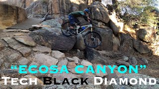
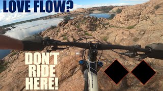
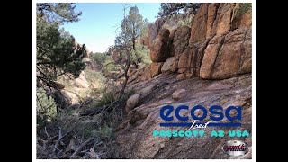
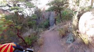
The ECOSA trail is a private easement trail that was created in collaboration between the City of Prescott and Prescott College. The trail is an out and back with lots of rock features and a couple of steel bridges.

Access Info

The trail connects to the Willow Loop trail near Willow Lake.

Local Trail Association
Traditionally Indigenous Territory

Recent Activity on Trail

Past Week
  • 0 rides
  •  
6 Months
  • 0 rides
  •  
All
  • 13 rides
  • Last: May 3, 2026
c1c2c3c4
January
February
March
April
May
June
July
August
September
October
November
December
update trails status or condition

ECOSA Trail Reports

statusdatedescription
Sep 27, 2020 @ 7:10am
Sep 27, 2020
Sep 22, 2020 @ 4:42pm
Sep 22, 2020
Mar 31, 2020 @ 12:31pm
Mar 31, 2020
Mar 16, 2020 @ 12:36pm
Mar 16, 2020
big pool of standing stagnant water in field at end, be prepared to walk right through or scramble 60ft up the dells to get around
more »
Status:
on Sep 27, 2020
Dry
Avg: 4.24 (2 votes)
Your vote: 0

view (174)
close
3D
Trail Conditions
  • Unknown
  • Snow Groomed
  • Snow Packed
  • Snow Covered
  • Snow Cover Partial
  • Freeze/thaw Cycle
  • Icy
  • Prevalent Mud
  • Wet
  • Variable
  • Ideal
  • Dry
  • Very Dry
Trail Flow (Ridden Direction)
Trailforks scans users ridelogs to determine the most popular direction each trail is ridden. A good flowing trail network will have most trails flowing in a single direction according to their intension.
The colour categories are based on what percentage of riders are riding a trail in its intended direction.
  • > 96%
  • > 90%
  • > 80%
  • > 70%
  • > 50%
  • < 50%
  • bi-directional trail
  • no data
Trail Last Ridden
Trailforks scans ridelogs to determine the last time a trail was ridden.
  • < 2 days
  • < 1 week
  • < 2 weeks
  • < 1 month
  • < 6 months
  • > 6 months
Trail Ridden Direction
The intended direction a trail should be ridden.
  • Downhill Only
  • Downhill Primary
  • Both Directions
  • Uphill Primary
  • Uphill Only
  • One Direction
Contribute Details
Colors indicate trail is missing specified detail.
  • Description
  • Photos
  • Description & Photos
  • Videos
Trail Popularity ?
Trailforks scans ridelogs to determine which trails are ridden the most in the last 9 months. Trails are compared with nearby trails in the same city region with a possible 25 colour shades. Think of this as a heatmap, more rides = more kinetic energy = warmer colors.
  • most popular
  • popular
  • less popular
  • not popular
ATV/ORV/OHV Filter
Max Vehicle Width
inches
US Cell Coverage
Legend
cell carrier legend

Radar Time
Activity Recordings
Trailforks uses anonymized public activity data. ?
Activity Recordings
Trailforks uses anonymized public activity data. ?
Personal Heatmap
Activity Types
all / none
Options
2
Date range month
Winter Trails
Warning A routing network for winter maps does not exist. Selecting trails using the winter trails layer has been disabled.
Missing Trails
Most Popular
Least Popular
Trails are colored based on popularity. The more popular a trail is, the more red. Less popular trails trend towards green.
Jump Magnitude Heatmap
Heatmap of where riders jump on trails. Zoom in to see individual jumps, click circles to view jump details.
BC Backroad Status

Service Road Atlas is a free to use, community-driven service for viewing and creating reports on the numerous back-country service roads around B.C. and Alberta.

map legend
Slope Aspect
Direction the slope faces
Flat N NE E SE S SW W NW
Trails Deemphasized
Trails are shown in grey.
disable
Only show trails with no bike usage.
Enable
Suggested Layers
Based on selected activity type

    Save the current map location and zoom level as your default home location whenever this page is loaded.

    Save
        Directions to ecosa trailhead (34.605530, -112.425580)

        Photos

        21 more »
        72 |
        Dec 16, 2021 @ 9:31pm
        Dec 16, 2021
        86 |
        Dec 16, 2021 @ 9:31pm
        Dec 16, 2021
        63 |
        Dec 16, 2021 @ 9:33pm
        Dec 16, 2021
        57 |
        Dec 16, 2021 @ 9:33pm
        Dec 16, 2021

        Videos

        4 more »
        This Canyon has it all! 'Ecosa' Trail in the...
        3:51 | 189 | Dec 16, 2022 , Prescott
        Double Black Tech MTB loop in the Willow Lake...
        8:56 | 162 | Sep 9, 2022 , Prescott
        ecosa Trail Willow Dells Prescott, AZ Arizona...
        14:47 | 395 | Dec 16, 2021 , Prescott
        youtuber ECOSA Trail - Willow Dells, Prescott, AZ
        2:06 | 604 | Jul 10, 2020 , Prescott

        Routes with this trail

        8 miles 871 ft 14
        2024 Dells Challenge by Kurt Refsnider and Bikesmith Cyclery

        Reviews / Comments

        No reviews yet, be the first to write a review or ask a question.
        Use trail reports to comment on trail conditions.


        We hope you've been enjoying Trailforks!

        Create a FREE account to view trail comments and much more.

        • By bbiggsTF Pro & contributors
        • #263723 - 3,815 views

        Frequently Asked Questions About ECOSA

        Where is ECOSA located?
        ECOSA is located in Granite Dells, Prescott, Arizona, United States. It is part of the Granite Dells trail network. The trailhead is located at coordinates 34.60553, -112.42558.
        How hard is ECOSA?
        ECOSA is rated as Black Diamond difficulty. The physical rating is Hard. The average grade is 1.7%. The climb difficulty is rated Black Diamond.
        What is the elevation gain for ECOSA?
        ECOSA has 106 ft of elevation gain. The trail has 59 ft of elevation descent. The elevation ranges from 5,063 ft to 5,134 ft.
        Is ECOSA a point to point trail?
        ECOSA is not a point to point trail. The direction is Both Directions. The trail type is singletrack.

        Hit the Trail

        Open in App

        Get this trail on your phone instantly.
        open trail in app

        Download Trail

        Save to wishlist, Garmin & download.
        save the trail

        Find Related Routes

        Find routes and users activities that include this trail.
        find routes for this trail

        You must enter a description before submitting.