more stats
1.6 miles
Distance
-1,143 ft
Descent
00:13:29
Avg time
-1,143 ft
Altitude change
2,779 ft
Altitude min
3,922 ft
Altitude max
3,922 ft
Altitude start
2,779 ft
Altitude end
-14%
Grade
-73.2%
Grade max
0.7%
Grade min
128 ft
Distance climb
1 mile
Distance down
200 ft
Distance flat
00:13:29
Avg time

Ernaitzu Details

  • Activities
    • Mountain Bike
    • E-Bike
    • Hike
    • Trail Running
  • Riding Area
    Basaburua
    Lekunberri
  • Difficulty Rating
  • Local Popularity
    95 in Mountain Biking [+]
    • 95 in E-Biking
    • 5 in Trail Running
    • 95 in Hiking
  • Global Ranking
    #5331 in Mountain Biking [+]
    • #23493 in E-Biking
    • #133220 in Trail Running
    • #22228 in Hiking
  • Trail Type
    Singletrack
  • Bike Type
    DH, AM
  • Direction
    Downhill Primary
    Popular Direction Shown
  • Climb Difficulty
    Blue
  • Physical Rating
    Moderate
  • Trail Visibility
    Sometimes hard to follow
  • Dogs Allowed
    Yes
  • eBike Allowed
    Yes up to Class 1

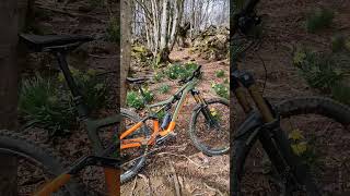
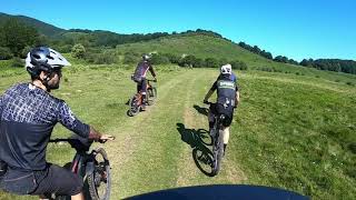
Sendero que desciende desde la cima del monte Ernaitzu (1204 m), de ahí su nombre. La cima herbosa es espectacular por sus vistas en los 360º: Pirineos, Peña Izaga, Higa de Monreal, Moncayo, Sierra de Aralar, etc. podremos ver en días de buena visibilidad.

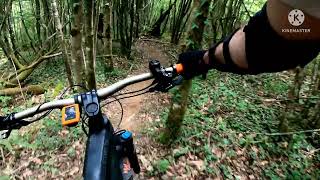
Sus faldas herbáceas hacen de este un lugar perfecto para el pasto del ganado del valle. Por ello, la primera parte de la bajada es un tanto "agro". Muchos senderos, sin un claro trazado, harán destacar al rider más habilidoso. Tras una primera parte de bosque en el que las raíces son protagonistas, salimos a una segunda campa herbácea. El sendero que la cruza desaparece, encendiendo nuestra bombilla de la orientación, ya que tendremos que cruzar la campa por el camino más corto.

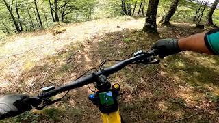
Inmediatamente, nos toparemos con la valla que nos separa de la felicidad. A partir de aquí, festín de curvas rápidas y zonas divertidas, a través de un precioso hayedo, por un camino antiguo divertidísimo creado por nuestros antepasados, el cual me hace pensar que intuían que dentro de unos años íbamos a disfrutar bajando en nuestra bici por ahí

Disclaimer

Precaución con senderistas

Trail Supporters
Local Trail Association

Recent Activity on Trail

Past Week
  • 2 rides
  • 19 miles average
6 Months
  • 10 rides
  • 17 miles avg distance
All
  • 122 rides
  • Last: Jun 2, 2026
c1c2c3c4
January
February
March
April
May
June
July
August
September
October
November
December
update trails status or condition

Ernaitzu Trail Reports

statusdatedescription
May 18, 2026 @ 9:21pm (Europe/Madrid)
May 18, 2026
reporter
Se ha pasado el soplahojas desde el cruce con Aldoki hasta el final. Parte final desbrozada también.
Apr 26, 2026 @ 10:55pm (Europe/Madrid)
Apr 26, 2026
Sendero muy recomendable, muy buenas vistas desde la cima. Es algo complicado ver la trazada si no vas con el track, sobretodo al principio.
Mar 2, 2026 @ 7:21pm (Europe/Madrid)
Mar 2, 2026
reporter
Se han cortado varios árboles caídos. Ahora se puede pasar todo sin tener que desmontarse, pero hay pequeñas ramas y hojas en todo el sendero.
Jan 14, 2026 @ 7:19pm (Europe/Madrid)
Jan 14, 2026
reporter Mucha hoja por todo el trazado y 2 árboles grandes caídos en la zona baja.
Nov 24, 2025 @ 9:25pm (Europe/Madrid)
Nov 24, 2025
reporter
more »
Status:
on May 18, 2026
Variable
Avg: 4.12 (19 votes)
Your vote: 0

view (459)
close
3D
Trail Conditions
  • Unknown
  • Snow Groomed
  • Snow Packed
  • Snow Covered
  • Snow Cover Partial
  • Freeze/thaw Cycle
  • Icy
  • Prevalent Mud
  • Wet
  • Variable
  • Ideal
  • Dry
  • Very Dry
Trail Flow (Ridden Direction)
Trailforks scans users ridelogs to determine the most popular direction each trail is ridden. A good flowing trail network will have most trails flowing in a single direction according to their intension.
The colour categories are based on what percentage of riders are riding a trail in its intended direction.
  • > 96%
  • > 90%
  • > 80%
  • > 70%
  • > 50%
  • < 50%
  • bi-directional trail
  • no data
Trail Last Ridden
Trailforks scans ridelogs to determine the last time a trail was ridden.
  • < 2 days
  • < 1 week
  • < 2 weeks
  • < 1 month
  • < 6 months
  • > 6 months
Trail Ridden Direction
The intended direction a trail should be ridden.
  • Downhill Only
  • Downhill Primary
  • Both Directions
  • Uphill Primary
  • Uphill Only
  • One Direction
Contribute Details
Colors indicate trail is missing specified detail.
  • Description
  • Photos
  • Description & Photos
  • Videos
Trail Popularity ?
Trailforks scans ridelogs to determine which trails are ridden the most in the last 9 months. Trails are compared with nearby trails in the same city region with a possible 25 colour shades. Think of this as a heatmap, more rides = more kinetic energy = warmer colors.
  • most popular
  • popular
  • less popular
  • not popular
ATV/ORV/OHV Filter
Max Vehicle Width
inches
US Cell Coverage
Legend
cell carrier legend

Radar Time
Activity Recordings
Trailforks uses anonymized public activity data. ?
Activity Recordings
Trailforks uses anonymized public activity data. ?
Personal Heatmap
Activity Types
all / none
Options
2
Date range month
Winter Trails
Warning A routing network for winter maps does not exist. Selecting trails using the winter trails layer has been disabled.
Missing Trails
Most Popular
Least Popular
Trails are colored based on popularity. The more popular a trail is, the more red. Less popular trails trend towards green.
Jump Magnitude Heatmap
Heatmap of where riders jump on trails. Zoom in to see individual jumps, click circles to view jump details.
BC Backroad Status

Service Road Atlas is a free to use, community-driven service for viewing and creating reports on the numerous back-country service roads around B.C. and Alberta.

map legend
Slope Aspect
Direction the slope faces
Flat N NE E SE S SW W NW
Trails Deemphasized
Trails are shown in grey.
disable
Only show trails with no bike usage.
Enable
Suggested Layers
Based on selected activity type

    Save the current map location and zoom level as your default home location whenever this page is loaded.

    Save
        Directions to ernaitzu trailhead (43.044420, -1.834720)

        Photos

        75 more »
        70 |
        Jan 4, 2022 @ 11:02am
        Jan 4, 2022
        33 |
        Sep 13, 2025 @ 12:14am
        Sep 13, 2025
        24 |
        Sep 13, 2025 @ 12:14am
        Sep 13, 2025
        29 |
        Sep 13, 2025 @ 12:14am
        Sep 13, 2025

        Videos

        5 more »
        R01. Jaiotze Basatia. Nacimiento salvaje MTB...
        0:35 | 103 | Mar 24, 2023 , Lekunberri
        Beruete: Ernaitzu
        8:54 | 150 | Oct 20, 2022 , Lekunberri
        1ª Basaburua Enduro KDD
        3:54 | 315 | Jun 8, 2022 , Lekunberri
        BERUETE MTB Ernaizu
        0:09 | 151 | Jan 3, 2022 , Lekunberri

        Routes with this trail

        4.5 11 miles 3,432 ft 11 Loop
        de , , que une tres buenos y variados senderos de bajada. Comenzando desde , no habrá tiempo para...
        5.0 25 miles 6,934 ft 31 Loop
        de , (Nacimiento salvaje) que une los pueblos de , y a través de un recorrido salvaje, convirtiéndolo en...
        5.0 19 miles 4,648 ft 24 Loop Race
        Track de la 3ª edición de la Basaburua Enduro Race.

        1 Review & Comments


        We hope you've been enjoying Trailforks!

        Create a FREE account to view trail comments and much more.

        Frequently Asked Questions About Ernaitzu

        Where is Ernaitzu located?
        Ernaitzu is located in Basaburua, Lekunberri, Spain. It is part of the Basaburua trail network. The trailhead is located at coordinates 43.04442, -1.83472.
        How hard is Ernaitzu?
        Ernaitzu is rated as Blue difficulty. The physical rating is Moderate. The average grade is 14%. The climb difficulty is rated Blue.
        What is the elevation gain for Ernaitzu?
        The trail has 1,143 ft of elevation descent. The elevation ranges from 2,779 ft to 3,922 ft.
        Is Ernaitzu a point to point trail?
        Ernaitzu is not a point to point trail. The direction is Downhill Primary. The trail type is singletrack.

        Hit the Trail

        Open in App

        Get this trail on your phone instantly.
        open trail in app

        Download Trail

        Save to wishlist, Garmin & download.
        save the trail

        Find Related Routes

        Find routes and users activities that include this trail.
        find routes for this trail

        You must enter a description before submitting.