more stats
2,999 ft
Distance
-391 ft
Descent
00:07:04
Avg time
-391 ft
Altitude change
1,906 ft
Altitude min
2,298 ft
Altitude max
2,298 ft
Altitude start
1,906 ft
Altitude end
-13.1%
Grade
-47.3%
Grade max
2,884 ft
Distance down
112 ft
Distance flat
00:07:04
Avg time

EXT Line Details

  • Activities
    • Mountain Bike
    • E-Bike
  • Riding Area
    Rocallaura Bikepark
    Rocallaura
  • Difficulty Rating
  • Voted Difficulty
    Red (2 votes)
  • Local Popularity
    60 in Mountain Biking [+]
    • 65 in E-Biking
  • Global Ranking
    #13413 in Mountain Biking [+]
    • #62623 in E-Biking
  • Trail Type
    Singletrack
  • Bike Type
    AM
  • Direction
    Downhill Only
    Popular Direction Shown
  • Trail Visibility
    Always easy to follow
  • eBike Allowed
    Yes up to Class 1
  • TTFs on Trail
    Berm, Jump, Gap Jump
  • Year Opened
    2023
  • Land Owner
    Antic Balneari de Rocallaura

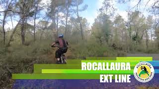
Baixada que porta el nom de la prestigiosa marca d'amortiguadors EXT-Shox Racing. Feta amb col.laboració de WildCoast Bikes i amb participació del trailbuilder internacional Willard Bruce. En general és facileta amb flow i peraltes varis però que te dos punts amb pendent, un quasi a la meitat i l'altre al final.

Trail Supporters
Local Trail Association

Recent Activity on Trail

Past Week
  • 0 rides
  •  
6 Months
  • 6 rides
  • 12 miles avg distance
All
  • 69 rides
  • Last: Jun 20, 2026
c1c2c3c4
January
February
March
April
May
June
July
August
September
October
November
December
update trails status or condition

EXT Line Trail Reports

Status:
on May 25, 2026
Dry
Avg: 4.33 (6 votes)
Your vote: 0

view (894)
close
3D
Trail Conditions
  • Unknown
  • Snow Groomed
  • Snow Packed
  • Snow Covered
  • Snow Cover Partial
  • Freeze/thaw Cycle
  • Icy
  • Prevalent Mud
  • Wet
  • Variable
  • Ideal
  • Dry
  • Very Dry
Trail Flow (Ridden Direction)
Trailforks scans users ridelogs to determine the most popular direction each trail is ridden. A good flowing trail network will have most trails flowing in a single direction according to their intension.
The colour categories are based on what percentage of riders are riding a trail in its intended direction.
  • > 96%
  • > 90%
  • > 80%
  • > 70%
  • > 50%
  • < 50%
  • bi-directional trail
  • no data
Trail Last Ridden
Trailforks scans ridelogs to determine the last time a trail was ridden.
  • < 2 days
  • < 1 week
  • < 2 weeks
  • < 1 month
  • < 6 months
  • > 6 months
Trail Ridden Direction
The intended direction a trail should be ridden.
  • Downhill Only
  • Downhill Primary
  • Both Directions
  • Uphill Primary
  • Uphill Only
  • One Direction
Contribute Details
Colors indicate trail is missing specified detail.
  • Description
  • Photos
  • Description & Photos
  • Videos
Trail Popularity ?
Trailforks scans ridelogs to determine which trails are ridden the most in the last 9 months. Trails are compared with nearby trails in the same city region with a possible 25 colour shades. Think of this as a heatmap, more rides = more kinetic energy = warmer colors.
  • most popular
  • popular
  • less popular
  • not popular
ATV/ORV/OHV Filter
Max Vehicle Width
inches
US Cell Coverage
Legend
cell carrier legend

Radar Time
Activity Recordings
Trailforks uses anonymized public activity data. ?
Activity Recordings
Trailforks uses anonymized public activity data. ?
Personal Heatmap
Activity Types
all / none
Options
2
Date range month
Winter Trails
Warning A routing network for winter maps does not exist. Selecting trails using the winter trails layer has been disabled.
Missing Trails
Most Popular
Least Popular
Trails are colored based on popularity. The more popular a trail is, the more red. Less popular trails trend towards green.
Jump Magnitude Heatmap
Heatmap of where riders jump on trails. Zoom in to see individual jumps, click circles to view jump details.
BC Backroad Status

Service Road Atlas is a free to use, community-driven service for viewing and creating reports on the numerous back-country service roads around B.C. and Alberta.

map legend
Slope Aspect
Direction the slope faces
Flat N NE E SE S SW W NW
Trails Deemphasized
Trails are shown in grey.
disable
Only show trails with no bike usage.
Enable
Suggested Layers
Based on selected activity type

    Save the current map location and zoom level as your default home location whenever this page is loaded.

    Save
        Directions to ext-line trailhead (41.502640, 1.139600)

        Photos

        0 more »
        39 |
        Jan 20, 2024 @ 12:33am
        Jan 20, 2024
        27 |
        Jan 20, 2024 @ 12:33am
        Jan 20, 2024
        28 |
        Jan 20, 2024 @ 12:33am
        Jan 20, 2024

        Videos

        1 more »
        Rocallaura bikepark - EXT Line
        3:32 | 289 | Jun 5, 2023 , Rocallaura

        Reviews / Comments

        No reviews yet, be the first to write a review or ask a question.
        Use trail reports to comment on trail conditions.


        We hope you've been enjoying Trailforks!

        Create a FREE account to view trail comments and much more.

        • By snaker4TF Pro TFSPAIN & contributors
        • #623810 - 611 views

        Frequently Asked Questions About EXT Line

        Where is EXT Line located?
        EXT Line is located in Rocallaura Bikepark, Rocallaura, Spain. It is part of the Rocallaura Bikepark trail network. The trailhead is located at coordinates 41.50264, 1.1396.
        How hard is EXT Line?
        EXT Line is rated as Red difficulty. The average grade is 13.1%.
        What is the elevation gain for EXT Line?
        The trail has 391 ft of elevation descent. The elevation ranges from 1,906 ft to 2,298 ft.
        Is EXT Line a point to point trail?
        Yes, EXT Line is a point to point trail. The direction is Downhill Only. The trail type is singletrack.

        Hit the Trail

        Open in App

        Get this trail on your phone instantly.
        open trail in app

        Download Trail

        Save to wishlist, Garmin & download.
        save the trail

        Find Related Routes

        Find routes and users activities that include this trail.
        find routes for this trail

        You must enter a description before submitting.