

more stats
3.4 miles
Distance
815 ft
Climb
-150 ft
Descent
00:49:18
Avg time
664 ft
Altitude change
4,775 ft
Altitude min
5,444 ft
Altitude max
4,775 ft
Altitude start
5,440 ft
Altitude end
3.7%
Grade
-21.9%
Grade max
26.9%
Grade min
2 miles
Distance climb
3,527 ft
Distance down
1,847 ft
Distance flat
00:49:18
Avg time

EZ Trail Details

  • Activities
    • Mountain Bike
    • Hike
    • Trail Running
  • Riding Area
    Kings Canyon
    Carson City, Nevada
  • Difficulty Rating
  • Voted Difficulty
    Black Diamond (1 vote)
  • Global Ranking
    #102126 in Mountain Biking [+]
    • #149328 in Trail Running
    • #95395 in Hiking
  • State Ranking
    #564 in Mountain Biking · Nevada [+]
    • #847 in Trail Running
    • #446 in Hiking
  • Trail Type
    Singletrack
  • Bike Type
    AM, XC, Fat
  • Direction
    Both Directions
  • Climb Difficulty
    Black Diamond
  • Physical Rating
    Hard
  • Dogs Allowed
    Yes

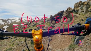
Compared to the trails in the Ash Canyon network, EZ Trail is generally more difficult, being both more strenuous and technical. The lower section of EZ has an average grade of 8 percent with multiple sections where the climbs exceed that. Additionally, some of the sections require riders to navigate through jagged volcanic rocks. The upper section is less steep but has a few loose scree fields that can be somewhat challenging to ride. This ride traverses the southern face of C-Hill, with very little vegetation or shade it can get quite hot in the summer.

This trail is unsanctioned.

Tags
Loose

Traditionally Indigenous Territory

Recent Activity on Trail

Past Week
  • 0 rides
  •  
6 Months
  • 18 rides
  • 11 miles avg distance
All
  • 199 rides
  • Last: Nov 7, 2026
c1c2c3c4
January
February
March
April
May
June
July
August
September
October
November
December
update trails status or condition

EZ Trail Trail Reports

statusdatedescription
Mar 10, 2026 @ 9:54am (America/Los_Angeles)
Mar 10, 2026
May 16, 2024 @ 5:35pm
May 16, 2024
Jan 13, 2024 @ 12:05pm
Jan 13, 2024
reporter Snow covered from 1/10/24 storm.
Apr 29, 2023 @ 11:27am
Apr 29, 2023
Entire trail is dry except for the the top 1/2 mile. Up top trail is fairly soft and rutted out.
May 12, 2021 @ 6:20pm
May 12, 2021
more »
Status:
on Mar 10, 2026
Ideal
Avg: 3.91 (7 votes)
Your vote: 0

view (830)
close
      Directions to ez-trail trailhead (39.152630, -119.769370)

      Photos

      9 more »
      mtb
      122 |
      Jul 12, 2025 @ 10:16pm
      Jul 12, 2025
      mtb
      145 |
      May 12, 2025 @ 2:22pm
      May 12, 2025
      mtb
      319 |
      Dec 26, 2020 @ 11:19am
      Dec 26, 2020
      mtb
      357 |
      Dec 26, 2020 @ 11:19am
      Dec 26, 2020

      Videos

      3 more »
      youtuber EZ Trail / Carson City, NV / MTB
      mtb
      12:45 | 654 | Jul 3, 2022 , Carson City
      (not so} EZ Trail...
      mtb
      3:36 | 500 | Jul 23, 2023 , Carson City
      youtuber Mountain Biking 2017 Carson City Off-Road Full Lap
      mtb
      1263 | Jun 22, 2017 , Carson City
      3.9 ★★★★★
      7 Ratings
      5 ★ 29%
      4 ★ 29%
      3 ★ 43%
      2 ★
      1 ★

      3 Reviews & Comments

      evkev27 evkev27
      Like a condensed version of Ash to Kings, this trail was surprisingly fun. Looped it with Lincoln Bypass and it made for a quick, fun after work rip.
      robertellisw robertellisw
      Surprised this trail doesn't have more reviews. Absolute blast riding west to east. Not sure I'd ever want to try it the other way. Several chunky bits at the top to work through and some scattered chunk along the descent. Nothing too crazy. I don't even know what trail raitings mean anymore. I guess this is a black by local standards?
      ccthecountry
      Road here last week. It was really hard for me as I am new to MTBing. But I pulled it off with only a few mishaps and a wipe out on the lower non technical portion (watch out for loose gravel). Beautiful views

      We hope you've been enjoying Trailforks!

      Create a FREE account to view all trail reviews and much more.

      • #85587 - 6,279 views

      Frequently Asked Questions

      ▼ Where is EZ Trail located?
      EZ Trail is located in Kings Canyon, Carson City, Nevada, United States. It is part of the Kings Canyon trail network. The trailhead is located at coordinates 39.15263, -119.76937.
      ▼ How hard is EZ Trail?
      EZ Trail is rated as Black Diamond difficulty. The physical rating is Hard. The average grade is 3.7%. The climb difficulty is rated Black Diamond.
      ▼ What is the elevation gain for EZ Trail?
      EZ Trail has 815 ft of elevation gain. The trail has 150 ft of elevation descent. The elevation ranges from 4,775 ft to 5,444 ft.
      ▼ Is EZ Trail a point to point trail?
      EZ Trail is not a point to point trail. The direction is Both Directions. The trail type is singletrack.
      ▼ How long is EZ Trail?
      EZ Trail is 3.4 miles long. The trail type is singletrack.
      ▼ Are dogs allowed on EZ Trail?
      Yes, dogs are allowed on EZ Trail. Please keep dogs on a leash where required and clean up after them.
      ▼ When is the best time of year to ride EZ Trail?
      Based on activity log data, the most popular months to ride EZ Trail are:
      • April (12 activities)
      • May (12 activities)
      • June (10 activities)
      Check the reports page for current trail conditions.
      ▼ How do I access EZ Trail? Where is the closest parking trailhead?
      The closest parking and trailhead locations to EZ Trail are: View all parking locations in the area.
      ▼ How long does it take to ride EZ Trail?
      Based on recorded activities, it takes an average of 49 minutes to ride EZ Trail. The trail is 3.4 miles long. Actual times will vary based on fitness level, conditions, and pace. View recent activity logs for more details.
      ▼ How busy is EZ Trail?
      EZ Trail is a very popular trail. There have been 777 recorded activities on this trail. The trail has received 830 check-ins. View recent activity on this trail.

      Hit the Trail

      Open in App

      Get this trail on your phone instantly.

      open trail in app

      Download Trail

      Save to wishlist, Garmin & download.
      save the trail

      Find Related Routes

      Find routes and users activities that include this trail.
      find routes for this trail

      You must enter a description before submitting.

