more stats
1.1 miles
Distance
8 ft
Climb
-336 ft
Descent
00:12:29
Avg time
-329 ft
Altitude change
1,434 ft
Altitude min
1,763 ft
Altitude max
1,763 ft
Altitude start
1,434 ft
Altitude end
-5.9%
Grade
-20%
Grade max
4.3%
Grade min
322 ft
Distance climb
4,596 ft
Distance down
620 ft
Distance flat
00:12:29
Avg time

Fabuleuse Details

  • Activities
    • Mountain Bike
    • E-Bike
    • Adaptive Bike
  • Riding Area
    Sentiers du Moulin
    Lac Beauport, Quebec
  • Difficulty Rating
  • Voted Difficulty
    Blue (1 vote)
  • Local Popularity
    95 in Mountain Biking [+]
    • 85 in E-Biking
  • Trail Type
    Singletrack
  • Bike Type
    AM, XC, Adaptive MTB
  • Climb Difficulty
    Green
  • Physical Rating
    Easy
  • Trail Visibility
    Always easy to follow
  • Family Friendly
    Yes
  • eBike Allowed
    Yes up to Class 1
  • TTFs on Trail
    Berm, Bridge
  • Year Opened
    2022
  • Land Owner

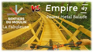
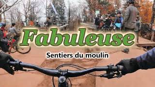
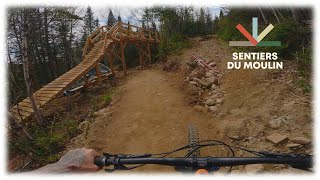
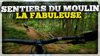
La Fabuleuse a été aménagée afin d’offrir à notre clientèle un long sentier de descente fluide très accessible sur le secteur SDM. Ce sentier a été aménagé par l'équipe SDM et Velosolutions Canada avec la contribution financière de Desjardins caisse de Charlebourg.

-----------------------------------------

Fabuleuse has been developed to offer our customers a long, very accessible flow trail in the SDM sector. This trail was built by the SDM team and Velosolutions Canada with the financial contribution of Desjardins Caisse de Charlebourg.

Adaptive Bike Info
aMTB Blue Rating: Intermediate features and steeper terrain.
Local Trail Association
Traditionally Indigenous Territory

Recent Activity on Trail

Past Week
  • 22 rides
  • 12 miles average
6 Months
  • 84 rides
  • 12 miles avg distance
All
  • 810 rides
  • Last: Jun 29, 2026
c1c2c3c4
January
February
March
April
May
June
July
August
September
October
November
December
Status:
on Jun 29, 2026
Ideal
Avg: 4.46 (9 votes)
Your vote: 0

view (6,083)
close
3D
Trail Conditions
  • Unknown
  • Snow Groomed
  • Snow Packed
  • Snow Covered
  • Snow Cover Partial
  • Freeze/thaw Cycle
  • Icy
  • Prevalent Mud
  • Wet
  • Variable
  • Ideal
  • Dry
  • Very Dry
Trail Flow (Ridden Direction)
Trailforks scans users ridelogs to determine the most popular direction each trail is ridden. A good flowing trail network will have most trails flowing in a single direction according to their intension.
The colour categories are based on what percentage of riders are riding a trail in its intended direction.
  • > 96%
  • > 90%
  • > 80%
  • > 70%
  • > 50%
  • < 50%
  • bi-directional trail
  • no data
Trail Last Ridden
Trailforks scans ridelogs to determine the last time a trail was ridden.
  • < 2 days
  • < 1 week
  • < 2 weeks
  • < 1 month
  • < 6 months
  • > 6 months
Trail Ridden Direction
The intended direction a trail should be ridden.
  • Downhill Only
  • Downhill Primary
  • Both Directions
  • Uphill Primary
  • Uphill Only
  • One Direction
Contribute Details
Colors indicate trail is missing specified detail.
  • Description
  • Photos
  • Description & Photos
  • Videos
Trail Popularity ?
Trailforks scans ridelogs to determine which trails are ridden the most in the last 9 months. Trails are compared with nearby trails in the same city region with a possible 25 colour shades. Think of this as a heatmap, more rides = more kinetic energy = warmer colors.
  • most popular
  • popular
  • less popular
  • not popular
ATV/ORV/OHV Filter
Max Vehicle Width
inches
US Cell Coverage
Legend
cell carrier legend

Radar Time
Activity Recordings
Trailforks uses anonymized public activity data. ?
Activity Recordings
Trailforks uses anonymized public activity data. ?
Personal Heatmap
Activity Types
all / none
Options
2
Date range month
Winter Trails
Warning A routing network for winter maps does not exist. Selecting trails using the winter trails layer has been disabled.
Missing Trails
Most Popular
Least Popular
Trails are colored based on popularity. The more popular a trail is, the more red. Less popular trails trend towards green.
Jump Magnitude Heatmap
Heatmap of where riders jump on trails. Zoom in to see individual jumps, click circles to view jump details.
BC Backroad Status

Service Road Atlas is a free to use, community-driven service for viewing and creating reports on the numerous back-country service roads around B.C. and Alberta.

map legend
Slope Aspect
Direction the slope faces
Flat N NE E SE S SW W NW
Trails Deemphasized
Trails are shown in grey.
disable
Only show trails with no bike usage.
Enable
Suggested Layers
Based on selected activity type

    Save the current map location and zoom level as your default home location whenever this page is loaded.

    Save
        Directions to fabuleuse trailhead (46.991800, -71.268980)

        Photos

        2 more »
        152 |
        Sep 20, 2022 @ 6:38am
        Sep 20, 2022
        197 |
        Sep 20, 2022 @ 6:37am
        Sep 20, 2022

        Videos

        7 more »
        youtuber Deux nouveautés intermédiaires à essayer...
        6:31 | 474 | Aug 4, 2022 , Lac Beauport
        Fabuleuse - Sentiers du Moulin
        5:09 | 170 | Nov 4, 2024 , Lac Beauport
        youtuber Sentiers du Moulin - Pas seulement un centre...
        15:25 | 144 | Jun 11, 2024 , Lac Beauport
        La Fabuleuse | Sentiers du Moulin
        10:29 | 160 | Oct 3, 2023 , Lac Beauport

        Routes with this trail

        6 miles 1,101 ft 6 Loop
        Ideal for a first enduro experience, this circuit allows you to explore the two types of terrain found at...
        18 miles 2,959 ft 21
        Club mathieu performance 30km entrainement

        3 Reviews & Comments


        We hope you've been enjoying Trailforks!

        Create a FREE account to view trail comments and much more.

        • By SentiersduMoulinTF Pro VQ SDM & contributors
        • #526147 - 1,902 views

        Frequently Asked Questions About Fabuleuse

        Where is Fabuleuse located?
        Fabuleuse is located in Sentiers du Moulin, Lac Beauport, Quebec, Canada. It is part of the Sentiers du Moulin trail network. The trailhead is located at coordinates 46.9918, -71.26898.
        How hard is Fabuleuse?
        Fabuleuse is rated as Blue difficulty. The physical rating is Easy. The average grade is 5.9%. The climb difficulty is rated Green.
        What is the elevation gain for Fabuleuse?
        Fabuleuse has 3 m of elevation gain. The trail has 103 m of elevation descent. The elevation ranges from 437 m to 537 m.
        How long is Fabuleuse?
        Fabuleuse is 1.7 km long. The trail type is singletrack.

        Hit the Trail

        Open in App

        Get this trail on your phone instantly.
        open trail in app

        Download Trail

        Save to wishlist, Garmin & download.
        save the trail

        Find Related Routes

        Find routes and users activities that include this trail.
        find routes for this trail

        You must enter a description before submitting.