Falcon Flow Details
-
Activities
- Mountain Bike
- Hike
- Trail Running
-
Riding AreaSand Flats Recreation Area
Moab, Utah -
Difficulty Rating
-
Voted DifficultyBlue (5 votes)
-
Trail TypeSingletrack
-
Bike TypeAM
-
DirectionBoth DirectionsPopular direction shown
-
Dogs AllowedYes
-
eBike Allowed
-
Global Ranking
-
Local Popularity100 in Mountain Biking [+]
- 55 in Trail Running
- 90 in Hiking
-
Land Owner
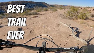
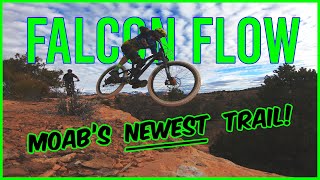
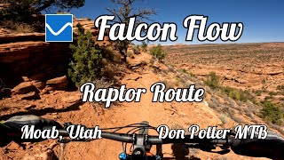
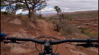
Falcon Flow (not a flow trail) is the 3rd trail on the Raptor Route. Falcon Flow features beautiful vistas with fun flowy singletrack mixed with some challenges along the way. This trail works on its own as a loop riding 2.7 miles up Sand Flats Road from the Falcon Flow Trail Head or as part of an alternate to the lower part of the Whole Enchilada. If the Whole Enchilada is beating you up, you're running low on food or water, or you're over your head, ride down the Raptor Route from the bottom of UPS or Porcupine Rim 4x4 Road. From the end of Falcon Flow it is 6 miles back to Moab on Sand Flats Road.
Access Info
From Town: Head up Sand Flats Road 6 miles. Entry fee is required in Sand Flats Recreation Area.
2024 prices have changed - $25 for a annual pass, otherwise you need a 7-day pass (no more daily passes).
$5 for bike/motorcycle/shuttle (driver)
$10 for a vehicle
Park only in designated areas. Please do not park on Sand Flats Road.
Disclaimer
This trail is in Sand Flats Recreation Area and requires a fee upon entry or exit at pay booth. Bike $2. Car $5.
Local Trail Association
-
Please consider joining or donating to the local trail association to supportdonate to earn trail karma!
trail development & maintenance.
Traditionally Indigenous Territory
More Stats for Falcon Flow mountain bike trail trail
-
Altitude change-744 ft
-
Altitude min5,112 ft
-
Altitude max5,870 ft
-
Altitude start5,856 ft
-
Altitude end5,112 ft
-
Grade-2.6%
-
Grade max-23.1%
-
Grade min31.2%
-
Distance climb1 mile
-
Distance down3 miles
-
Distance flat3,678 ft
-
Avg time00:56:10
-
Avg reverse time01:08:48
- view trail stats
- Unknown
- Snow Groomed
- Snow Packed
- Snow Covered
- Snow Cover Partial
- Freeze/thaw Cycle
- Icy
- Prevalent Mud
- Wet
- Variable
- Ideal
- Dry
- Very Dry
The colour categories are based on what percentage of riders are riding a trail in its intended direction.
- > 96%
- > 90%
- > 80%
- > 70%
- > 50%
- < 50%
- bi-directional trail
- no data
- < 2 days
- < 1 week
- < 2 weeks
- < 1 month
- < 6 months
- > 6 months
- Downhill Only
- Downhill Primary
- Both Directions
- Uphill Primary
- Uphill Only
- One Direction
- Description
- Photos
- Description & Photos
- Videos
- most popular
- popular
- less popular
- not popular
- mountain biking recent
- mountain biking (>6 month)
- hiking (1 year)
- moto (1 year)
- Downhill Ski
- Backcountry Ski
- Nordic Ski
- Snowmobile
Save the current map location and zoom level as your default home location whenever this page is loaded.
SaveFalcon Flow Trail Reports
Recent Ridelog Activity on Trail
- 1 rides
- 14 miles avg distance
- 278 rides
- 16 miles avg distance
- 1,627 rides
- Last: Jun 19, 2025
Photos
Routes with this trail
28 Reviews & Comments
We hope you've been enjoying Trailforks!
Create a FREE account to view trail comments and much more.
Videos
Nearby Trails
- Porcupine Rim Sand Flats Access 1,483 ft
- Lower Porcupine Rim 4x4 Dead End 2 miles
- Porcupine 4x4 Lower 2 miles
- Lower Porcupine 4x4 Road 2 miles
- Hawks Glide 3 miles
Sand Flats Recreation Area
- By GrandCountyTrails
MTM & contributors
- #261535 - 30,859 views
- follow/subscribe
- login to download gpx or kml files.
You must enter a description before submitting.