more stats
1,089 ft
Distance
-335 ft
Descent
00:00:55
Avg time
-335 ft
Altitude change
511 ft
Altitude min
846 ft
Altitude max
846 ft
Altitude start
512 ft
Altitude end
-30.8%
Grade
-73.7%
Grade max
-6.3%
Grade min
1,089 ft
Distance down
00:00:55
Avg time

Felonix Details

  • Activities
    • Mountain Bike
    • Hike
    • Trail Running
  • Riding Area
    San Juan Capistrano
    California
  • Difficulty Rating
  • Voted Difficulty
    Black Diamond (2 votes)
  • Local Popularity
    35 in Mountain Biking [+]
    • 5 in Trail Running
    • 65 in Hiking
  • Global Ranking
    #39478 in Mountain Biking [+]
    • #302743 in Trail Running
    • #93077 in Hiking
  • Trail Type
    Singletrack
  • Bike Type
    AM
  • Direction
    Downhill Only
    Popular Direction Shown
  • Physical Rating
    Hard
  • Trail Visibility
    Always easy to follow
  • Dogs Allowed
    Yes
  • eBike Allowed
  • TTFs on Trail
    Berm, Skinny
  • Ride in Rain
    Yes

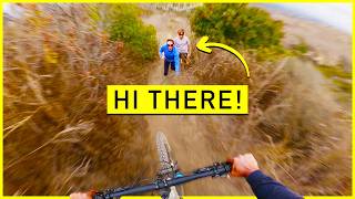
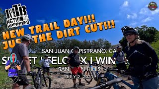
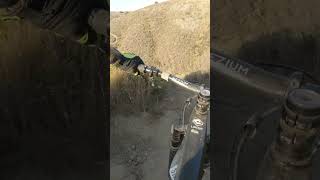
A steep singletrack that starts across from the top of B- Lopes. It cuts through Two Balls and a Bone about half way down and dumps you out on the Delgado Canyon trail. It is recomended to do after a rain so it has some traction.

Access Info

It is about 20 feet up from the top of B- Lopes on the opposite side of the trail.

Disclaimer

Watch out for riders on Two Balls and a Bone

Local Trail Association
Traditionally Indigenous Territory

Recent Activity on Trail

Past Week
  • 0 rides
  •  
6 Months
  • 2 rides
  • 18 miles avg distance
All
  • 38 rides
  • Last: May 2, 2026
c1c2c3c4
January
February
March
April
May
June
July
August
September
October
November
December
update trails status or condition

Felonix Trail Reports

Status:
on Dec 8, 2025
Ideal
Avg: 4.1 (3 votes)
Your vote: 0

view (416)
close
3D
Trail Conditions
  • Unknown
  • Snow Groomed
  • Snow Packed
  • Snow Covered
  • Snow Cover Partial
  • Freeze/thaw Cycle
  • Icy
  • Prevalent Mud
  • Wet
  • Variable
  • Ideal
  • Dry
  • Very Dry
Trail Flow (Ridden Direction)
Trailforks scans users ridelogs to determine the most popular direction each trail is ridden. A good flowing trail network will have most trails flowing in a single direction according to their intension.
The colour categories are based on what percentage of riders are riding a trail in its intended direction.
  • > 96%
  • > 90%
  • > 80%
  • > 70%
  • > 50%
  • < 50%
  • bi-directional trail
  • no data
Trail Last Ridden
Trailforks scans ridelogs to determine the last time a trail was ridden.
  • < 2 days
  • < 1 week
  • < 2 weeks
  • < 1 month
  • < 6 months
  • > 6 months
Trail Ridden Direction
The intended direction a trail should be ridden.
  • Downhill Only
  • Downhill Primary
  • Both Directions
  • Uphill Primary
  • Uphill Only
  • One Direction
Contribute Details
Colors indicate trail is missing specified detail.
  • Description
  • Photos
  • Description & Photos
  • Videos
Trail Popularity ?
Trailforks scans ridelogs to determine which trails are ridden the most in the last 9 months. Trails are compared with nearby trails in the same city region with a possible 25 colour shades. Think of this as a heatmap, more rides = more kinetic energy = warmer colors.
  • most popular
  • popular
  • less popular
  • not popular
ATV/ORV/OHV Filter
Max Vehicle Width
inches
US Cell Coverage
Legend
cell carrier legend

Radar Time
Activity Recordings
Trailforks uses anonymized public activity data. ?
Activity Recordings
Trailforks uses anonymized public activity data. ?
Personal Heatmap
Activity Types
all / none
Options
2
Date range month
Winter Trails
Warning A routing network for winter maps does not exist. Selecting trails using the winter trails layer has been disabled.
Missing Trails
Most Popular
Least Popular
Trails are colored based on popularity. The more popular a trail is, the more red. Less popular trails trend towards green.
Jump Magnitude Heatmap
Heatmap of where riders jump on trails. Zoom in to see individual jumps, click circles to view jump details.
BC Backroad Status

Service Road Atlas is a free to use, community-driven service for viewing and creating reports on the numerous back-country service roads around B.C. and Alberta.

map legend
Slope Aspect
Direction the slope faces
Flat N NE E SE S SW W NW
Trails Deemphasized
Trails are shown in grey.
disable
Only show trails with no bike usage.
Enable
Suggested Layers
Based on selected activity type

    Save the current map location and zoom level as your default home location whenever this page is loaded.

    Save
        Directions to felonix trailhead (33.476740, -117.648460)

        Photos

        No photos have been added for Felonix yet, add a photo.

        Videos

        5 more »
        youtuber Las Ramblas. Steep and Flowy MTB Trails. Santa...
        22:36 | 193 | Feb 3, 2025 , My City
        youtuber MTB Riding The Steeps | New Trail Day!!! |...
        11:26 | 239 | Jul 4, 2023 , My City
        youtuber MTB Riding The Steeps | New Trail Day!!! | San...
        19:22 | 125 | Jul 4, 2023 , My City
        youtuber Felonix Mountain Biking Las Ramblas #felonix...
        0:17 | 82 | Mar 8, 2025 , My City

        3 Reviews & Comments


        We hope you've been enjoying Trailforks!

        Create a FREE account to view trail comments and much more.

        • By JPMTB999 & contributors
        • #400108 - 1,071 views

        Frequently Asked Questions About Felonix

        Where is Felonix located?
        Felonix is located in San Juan Capistrano, California, United States. It is part of the San Juan Capistrano trail network. The trailhead is located at coordinates 33.47674, -117.64846.
        How hard is Felonix?
        Felonix is rated as Double Black Diamond difficulty. The physical rating is Hard. The average grade is 30.8%.
        What is the elevation gain for Felonix?
        The trail has 335 ft of elevation descent. The elevation ranges from 511 ft to 846 ft.
        Is Felonix a point to point trail?
        Yes, Felonix is a point to point trail. The direction is Downhill Only. The trail type is singletrack.

        Hit the Trail

        Open in App

        Get this trail on your phone instantly.
        open trail in app

        Download Trail

        Save to wishlist, Garmin & download.
        save the trail

        Find Related Routes

        Find routes and users activities that include this trail.
        find routes for this trail

        You must enter a description before submitting.