more stats
4,639 ft
Distance
2 ft
Climb
-687 ft
Descent
00:07:28
Avg time
-684 ft
Altitude change
8,396 ft
Altitude min
9,081 ft
Altitude max
9,081 ft
Altitude start
8,396 ft
Altitude end
-14.8%
Grade
-44.7%
Grade max
-0.2%
Grade min
102 ft
Distance climb
4,537 ft
Distance down
00:07:28
Avg time

Firebox Details

  • Activities
    • Mountain Bike
    • Horse
    • Hike
    • Trail Running
  • Riding Area
    West Eagle
    Eagle, Colorado
  • Difficulty Rating
  • Local Popularity
    35 in Mountain Biking [+]
    • 60 in Trail Running
    • 5 in Hiking
    • 5 in Horseback
  • Global Ranking
    #117545 in Mountain Biking [+]
    • #105769 in Trail Running
    • #131958 in Hiking
    • #1635 in Horseback
  • Hiking SAC Scale
    T1 Hiking
  • Trail Type
    Singletrack
  • Direction
    Downhill Primary
    Popular Direction Shown
  • Dogs Allowed
    Yes
  • eBike Allowed

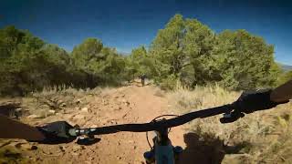
The trail starts next to a small post within the trees. The initial descent has some good turns and a couple areas that get more technical. It's all singletrack within the wooded area. There are a couple of small creek crossings. Be careful at each of these as they have sharp entrances and exits to the creek. Eventually, you'll reach a turn off to access Dead Cow.

If you continue past, there is a small climb to gain access to the open area and the start of Mike's Night Out.

Trail Supporters
  • BLM
    BLM
    Land Manager

  • USFS
    Land Manager
Local Trail Association
Traditionally Indigenous Territory

Recent Activity on Trail

Past Week
  • 0 rides
  •  
6 Months
  • 1 rides
  • 11 miles avg distance
All
  • 16 rides
  • Last: May 16, 2026
c1c2c3c4
January
February
March
April
May
June
July
August
September
October
November
December
update trails status or condition

Firebox Trail Reports

statusdatedescription
May 16, 2026 @ 9:58am (America/Denver)
May 16, 2026
reporter
Apr 16, 2026 @ 12:03am (America/Los_Angeles)
Apr 16, 2026
Dec 1, 2025 @ 1:00am (America/Denver)
Dec 1, 2025
reporter This trail is closed seasonally to all users from 12/1 thru 4/15 to protect deer and elk habitat.
May 24, 2025 @ 3:41pm
May 24, 2025
Apr 16, 2025 @ 12:03am
Apr 16, 2025
more »
Status:
on May 16, 2026
Ideal
Avg: 3.74 (3 votes)
Your vote: 0

view (201)
close
3D
Trail Conditions
  • Unknown
  • Snow Groomed
  • Snow Packed
  • Snow Covered
  • Snow Cover Partial
  • Freeze/thaw Cycle
  • Icy
  • Prevalent Mud
  • Wet
  • Variable
  • Ideal
  • Dry
  • Very Dry
Trail Flow (Ridden Direction)
Trailforks scans users ridelogs to determine the most popular direction each trail is ridden. A good flowing trail network will have most trails flowing in a single direction according to their intension.
The colour categories are based on what percentage of riders are riding a trail in its intended direction.
  • > 96%
  • > 90%
  • > 80%
  • > 70%
  • > 50%
  • < 50%
  • bi-directional trail
  • no data
Trail Last Ridden
Trailforks scans ridelogs to determine the last time a trail was ridden.
  • < 2 days
  • < 1 week
  • < 2 weeks
  • < 1 month
  • < 6 months
  • > 6 months
Trail Ridden Direction
The intended direction a trail should be ridden.
  • Downhill Only
  • Downhill Primary
  • Both Directions
  • Uphill Primary
  • Uphill Only
  • One Direction
Contribute Details
Colors indicate trail is missing specified detail.
  • Description
  • Photos
  • Description & Photos
  • Videos
Trail Popularity ?
Trailforks scans ridelogs to determine which trails are ridden the most in the last 9 months. Trails are compared with nearby trails in the same city region with a possible 25 colour shades. Think of this as a heatmap, more rides = more kinetic energy = warmer colors.
  • most popular
  • popular
  • less popular
  • not popular
ATV/ORV/OHV Filter
Max Vehicle Width
inches
US Cell Coverage
Legend
cell carrier legend

Radar Time
Activity Recordings
Trailforks uses anonymized public activity data. ?
Activity Recordings
Trailforks uses anonymized public activity data. ?
Personal Heatmap
Activity Types
all / none
Options
2
Date range month
Winter Trails
Warning A routing network for winter maps does not exist. Selecting trails using the winter trails layer has been disabled.
Missing Trails
Most Popular
Least Popular
Trails are colored based on popularity. The more popular a trail is, the more red. Less popular trails trend towards green.
Jump Magnitude Heatmap
Heatmap of where riders jump on trails. Zoom in to see individual jumps, click circles to view jump details.
BC Backroad Status

Service Road Atlas is a free to use, community-driven service for viewing and creating reports on the numerous back-country service roads around B.C. and Alberta.

map legend
Slope Aspect
Direction the slope faces
Flat N NE E SE S SW W NW
Trails Deemphasized
Trails are shown in grey.
disable
Only show trails with no bike usage.
Enable
Suggested Layers
Based on selected activity type

    Save the current map location and zoom level as your default home location whenever this page is loaded.

    Save
        Directions to firebox trailhead (39.572410, -106.856050)

        Photos

        6 more »
        57 |
        Oct 14, 2017 @ 7:20pm
        Oct 14, 2017
        70 |
        Oct 14, 2017 @ 7:18pm
        Oct 14, 2017
        41 |
        Oct 14, 2017 @ 7:18pm
        Oct 14, 2017
        49 |
        Oct 14, 2017 @ 7:18pm
        Oct 14, 2017

        Videos

        1 more »
        Eagle Empanada Downhill
        7:52 | 54 | Aug 5, 2024 , Eagle

        Routes with this trail

        1.0 36 miles 5,908 ft 17
        2019 Hardscrabble Humper Mountain Bike Route. More info and sign-up here: https://hardscrabblehumper.com/mtb/
        18 miles 3,366 ft 12 Loop
        Short back country Eagle tour
        17 miles 2,694 ft 20 Point to Point
        New route, moderate terrain, uphill than a fun downhill.

        Reviews / Comments

        No reviews yet, be the first to write a review or ask a question.
        Use trail reports to comment on trail conditions.


        We hope you've been enjoying Trailforks!

        Create a FREE account to view trail comments and much more.

        Nearby Trails

        • By toddTF Pro Trailforks & contributors
        • #14201 - 2,048 views

        Frequently Asked Questions About Firebox

        Where is Firebox located?
        Firebox is located in West Eagle, Eagle, Colorado, United States. It is part of the West Eagle trail network. The trailhead is located at coordinates 39.57241, -106.85605.
        How hard is Firebox?
        Firebox is rated as Blue difficulty. The average grade is 14.8%.
        What is the elevation gain for Firebox?
        Firebox has 2 ft of elevation gain. The trail has 687 ft of elevation descent. The elevation ranges from 8,396 ft to 9,081 ft.
        Is Firebox a point to point trail?
        Firebox is not a point to point trail. The direction is Downhill Primary. The trail type is singletrack.

        Hit the Trail

        Open in App

        Get this trail on your phone instantly.
        open trail in app

        Download Trail

        Save to wishlist, Garmin & download.
        save the trail

        Find Related Routes

        Find routes and users activities that include this trail.
        find routes for this trail

        You must enter a description before submitting.