more stats
2,293 ft
Distance
47 ft
Climb
-55 ft
Descent
00:05:06
Avg time
-9 ft
Altitude change
382 ft
Altitude min
424 ft
Altitude max
397 ft
Altitude start
387 ft
Altitude end
-0.4%
Grade
-20.6%
Grade max
17.6%
Grade min
823 ft
Distance climb
938 ft
Distance down
531 ft
Distance flat
00:05:06
Avg time

Fiveplay Details

  • Activities
    • Mountain Bike
    • E-Bike
    • Winter Fat Bike
    • Hike
    • Trail Running
    • Snowshoe
  • Riding Area
    Don Valley
    Toronto, Ontario
  • Difficulty Rating
  • Voted Difficulty
    Blue (1 vote)
  • Local Popularity
    95 in Mountain Biking [+]
    • 90 in E-Biking
    • 80 in Trail Running
    • 90 in Hiking
    • 5 in Snowshoeing
  • Global Ranking
    #50727 in Mountain Biking [+]
    • #13060 in E-Biking
    • #63556 in Trail Running
    • #40956 in Hiking
    • #2299 in Snowshoeing
  • Trail Type
    Singletrack
  • Bike Type
    AM, XC, Fat
  • Direction
    Uphill Primary
    Popular Direction Shown
  • Climb Difficulty
    Black Diamond
  • Physical Rating
    Moderate
  • Trail Visibility
    Always easy to follow
  • Dogs Allowed
    Yes
  • eBike Allowed
    Yes up to Class 1
  • TTFs on Trail
    Jump, Roller Coaster
  • Land Owner
    City of Toronto / Toronto Region Conservation Authority

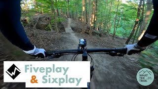
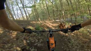
Mostly a tight climbing trail with a few quick downhills. Starts just up the paved road from the end of RollerFlowster, you can exit early and continue onto Sixplay.

This trail is unsanctioned.

Disclaimer

please do not ride in the mud

Recent Activity on Trail

Past Week
  • 21 rides
  • 12 miles average
6 Months
  • 78 rides
  • 14 miles avg distance
All
  • 1,270 rides
  • Last: Jun 10, 2026
c1c2c3c4
January
February
March
April
May
June
July
August
September
October
November
December
update trails status or condition

Fiveplay Trail Reports

statusdatedescription
Apr 23, 2026 @ 5:54pm (America/Toronto)
Apr 23, 2026
Apr 10, 2026 @ 6:34am (America/Toronto)
Apr 10, 2026
need to fill in this hole that's currently making the eastern climb line quite narrow
Apr 9, 2026 @ 12:26pm (America/Toronto)
Apr 9, 2026
lots of leaves
Nov 17, 2025 @ 10:12pm (America/Toronto)
Nov 17, 2025
recently leaf-blown by another one of the Don Valley Rodents
Jun 16, 2025 @ 7:49pm
Jun 16, 2025
more »
Status:
on Apr 23, 2026
Variable
Avg: 3.47 (13 votes)
Your vote: 0

view (5,294)
close
3D
Trail Conditions
  • Unknown
  • Snow Groomed
  • Snow Packed
  • Snow Covered
  • Snow Cover Partial
  • Freeze/thaw Cycle
  • Icy
  • Prevalent Mud
  • Wet
  • Variable
  • Ideal
  • Dry
  • Very Dry
Trail Flow (Ridden Direction)
Trailforks scans users ridelogs to determine the most popular direction each trail is ridden. A good flowing trail network will have most trails flowing in a single direction according to their intension.
The colour categories are based on what percentage of riders are riding a trail in its intended direction.
  • > 96%
  • > 90%
  • > 80%
  • > 70%
  • > 50%
  • < 50%
  • bi-directional trail
  • no data
Trail Last Ridden
Trailforks scans ridelogs to determine the last time a trail was ridden.
  • < 2 days
  • < 1 week
  • < 2 weeks
  • < 1 month
  • < 6 months
  • > 6 months
Trail Ridden Direction
The intended direction a trail should be ridden.
  • Downhill Only
  • Downhill Primary
  • Both Directions
  • Uphill Primary
  • Uphill Only
  • One Direction
Contribute Details
Colors indicate trail is missing specified detail.
  • Description
  • Photos
  • Description & Photos
  • Videos
Trail Popularity ?
Trailforks scans ridelogs to determine which trails are ridden the most in the last 9 months. Trails are compared with nearby trails in the same city region with a possible 25 colour shades. Think of this as a heatmap, more rides = more kinetic energy = warmer colors.
  • most popular
  • popular
  • less popular
  • not popular
ATV/ORV/OHV Filter
Max Vehicle Width
inches
US Cell Coverage
Legend
cell carrier legend

Radar Time
Activity Recordings
Trailforks uses anonymized public activity data. ?
Activity Recordings
Trailforks uses anonymized public activity data. ?
Personal Heatmap
Activity Types
all / none
Options
2
Date range month
Winter Trails
Warning A routing network for winter maps does not exist. Selecting trails using the winter trails layer has been disabled.
Missing Trails
Most Popular
Least Popular
Trails are colored based on popularity. The more popular a trail is, the more red. Less popular trails trend towards green.
Jump Magnitude Heatmap
Heatmap of where riders jump on trails. Zoom in to see individual jumps, click circles to view jump details.
BC Backroad Status

Service Road Atlas is a free to use, community-driven service for viewing and creating reports on the numerous back-country service roads around B.C. and Alberta.

map legend
Slope Aspect
Direction the slope faces
Flat N NE E SE S SW W NW
Trails Deemphasized
Trails are shown in grey.
disable
Only show trails with no bike usage.
Enable
Suggested Layers
Based on selected activity type

    Save the current map location and zoom level as your default home location whenever this page is loaded.

    Save
        Directions to fiveplay trailhead (43.723040, -79.368380)

        Photos

        11 more »
        120 |
        Jul 26, 2018 @ 5:52am
        Jul 26, 2018
        2,938 |
        Jul 26, 2018 @ 5:52am
        Jul 26, 2018
        47 |
        Apr 10, 2026 @ 3:35am
        Apr 10, 2026
        59 |
        Apr 21, 2025 @ 3:39pm
        Apr 21, 2025

        Videos

        2 more »
        Fiveplay and Sixplay - Don Valley MTB
        12:10 | 333 | Aug 4, 2021 , Toronto
        youtuber Don Valley Bike Trails: Fiveplay POV
        3:39 | 570 | May 23, 2020 , Toronto

        Routes with this trail

        5.0 59 miles 5,018 ft 111 Loop
        100k loop through the greater Valley, the route has almost no repeat sections. Consists mostly of...
        3.9 16 miles 1,371 ft 56
        Big loop in the Don featuring a good mix of the standards and the more difficult trails at the north end.
        5.0 24 miles 2,515 ft 41
        40 km of the best trails in the Don! Not for the timid :P

        3 Reviews & Comments


        We hope you've been enjoying Trailforks!

        Create a FREE account to view trail comments and much more.

        • #69612 - 4,046 views

        Frequently Asked Questions About Fiveplay

        Where is Fiveplay located?
        Fiveplay is located in Don Valley, Toronto, Ontario, Canada. It is part of the Don Valley trail network. The trailhead is located at coordinates 43.72304, -79.36838.
        How hard is Fiveplay?
        Fiveplay is rated as Black Diamond difficulty. The physical rating is Moderate. The average grade is 0.4%. The climb difficulty is rated Black Diamond.
        What is the elevation gain for Fiveplay?
        Fiveplay has 47 ft of elevation gain. The trail has 55 ft of elevation descent. The elevation ranges from 382 ft to 424 ft.
        Is Fiveplay a point to point trail?
        Fiveplay is not a point to point trail. The direction is Uphill Primary. The trail type is singletrack.

        Hit the Trail

        Open in App

        Get this trail on your phone instantly.
        open trail in app

        Download Trail

        Save to wishlist, Garmin & download.
        save the trail

        Find Related Routes

        Find routes and users activities that include this trail.
        find routes for this trail

        You must enter a description before submitting.