1,667 ft
Distance
8 ft
Climb
-146 ft
Descent
00:01:55
Avg time

Flashback 3 Details

  • Activities
    • Mountain Bike
    • E-Bike
    • Hike
    • Trail Running
  • Riding Area
    Cheakamus
    Whistler, British Columbia
  • Difficulty Rating
  • Hiking SAC Scale
    T1 Hiking
  • Trail Type
    Singletrack
  • Bike Type
    AM, XC, Gravel
  • Direction
    Downhill Primary
    Popular direction shown
  • Climb Difficulty
    Blue
  • Physical Rating
    Moderate
  • Trail Visibility
    Always easy to follow
  • Family Friendly
    Yes
  • Dogs Allowed
    Yes
  • eBike Allowed
    Yes up to Class 1
  • Local Popularity
    100 in Mountain Biking [+]
    • 95 in E-Biking
    • 85 in Trail Running
    • 80 in Hiking

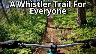
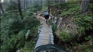
Flashback is a PLANNED intermediate trail that will connect Far Out to AM/PM/Interpretive Forest parking lot. Currently in final stages of authorization, this trail is planned to be constructed after the Cheakamus Community Forest completes fuel management for fire hazard reductions along Cheakamus Lake road in the coming months.

This trail will provide a return trail on the uphill side of Cheakamus Lake road and reduce two-way traffic on Farside/Riverside enhancing users experience and safety.

This development will provide WORCA with a great community project and will hopefully utilize our highly successful trail nights to complete the majority of the work.

Local Trail Association
More Stats for Flashback 3 mountain bike trail trail
  • Altitude change
    -140 ft
  • Altitude min
    2,224 ft
  • Altitude max
    2,372 ft
  • Altitude start
    2,364 ft
  • Altitude end
    2,224 ft
  • Grade
    -8.4%
  • Grade max
    -25.9%
  • Grade min
    6.1%
  • Distance climb
    171 ft
  • Distance down
    1,283 ft
  • Distance flat
    213 ft
  • Avg time
    00:01:55
  • Avg reverse time
    00:04:11
  • view trail stats
Status:
on Nov 28, 2024
Snow Covered
Avg: 4.06 (8 votes)
Your vote: 0

view (3,599)
close
3D
Trail Conditions
  • Unknown
  • Snow Groomed
  • Snow Packed
  • Snow Covered
  • Snow Cover Partial
  • Freeze/thaw Cycle
  • Icy
  • Prevalent Mud
  • Wet
  • Variable
  • Ideal
  • Dry
  • Very Dry
Trail Flow (Ridden Direction)
Trailforks scans users ridelogs to determine the most popular direction each trail is ridden. A good flowing trail network will have most trails flowing in a single direction according to their intension.
The colour categories are based on what percentage of riders are riding a trail in its intended direction.
  • > 96%
  • > 90%
  • > 80%
  • > 70%
  • > 50%
  • < 50%
  • bi-directional trail
  • no data
Trail Last Ridden
Trailforks scans ridelogs to determine the last time a trail was ridden.
  • < 2 days
  • < 1 week
  • < 2 weeks
  • < 1 month
  • < 6 months
  • > 6 months
Trail Ridden Direction
The intended direction a trail should be ridden.
  • Downhill Only
  • Downhill Primary
  • Both Directions
  • Uphill Primary
  • Uphill Only
  • One Direction
Contribute Details
Colors indicate trail is missing specified detail.
  • Description
  • Photos
  • Description & Photos
  • Videos
Trail Popularity ?
Trailforks scans ridelogs to determine which trails are ridden the most in the last 9 months. Trails are compared with nearby trails in the same city region with a possible 25 colour shades. Think of this as a heatmap, more rides = more kinetic energy = warmer colors.
  • most popular
  • popular
  • less popular
  • not popular
ATV/ORV/OHV Filter
Max Vehicle Width
inches
US Cell Coverage
Legend
cell carrier legend

Radar Time
x Activity Recordings
Trailforks users anonymized public ridelogs from the past 6 months.
  • mountain biking recent
  • mountain biking (>6 month)
  • hiking (1 year)
  • moto (1 year)
Activity Recordings
Trailforks users anonymized public skilogs from the past 12 months.
  • Downhill Ski
  • Backcountry Ski
  • Nordic Ski
  • Snowmobile
Winter Trails
Warning A routing network for winter maps does not exist. Selecting trails using the winter trails layer has been disabled.
x Missing Trails
Most Popular
Least Popular
Trails are colored based on popularity. The more popular a trail is, the more red. Less popular trails trend towards green.
Jump Magnitude Heatmap
Heatmap of where riders jump on trails. Zoom in to see individual jumps, click circles to view jump details.
Trails Deemphasized
Trails are shown in grey.
disable
Only show trails with NO bikes.
enable

Save the current map location and zoom level as your default home location whenever this page is loaded.

Save
      Directions to flashback-3 trailhead (50.064340, -123.027640)
      update trails status or condition

      Flashback 3 Trail Reports

      statusdatedescription
      Nov 28, 2024 @ 7:58pm
      Nov 28, 2024
      Oct 21, 2024 @ 1:46pm
      Oct 21, 2024
      Oct 12, 2024 @ 12:38pm
      Oct 12, 2024
      Sep 14, 2024 @ 10:55am
      Sep 14, 2024
      Trails in good condition. Had been a bit of rain, but tread is still solid. No trees down or obstructions.
      Aug 24, 2024 @ 1:20pm
      Aug 24, 2024
      view all reports »

      Recent Ridelog Activity on Trail

      Past Week
      • 0 rides
      •  
      6 Months
      • 70 rides
      • 15.1 km avg distance
      All
      • 785 rides
      • Last: Nov 20, 2023

      Photos

      no photos have been added for Flashback 3 yet, add a photo.

      Trail Products

      1 Review & Comments


      We hope you've been enjoying Trailforks!

      Create a FREE account to view trail comments and much more.

      Videos

      more »
      I Love this trail! | Flashback | Blue flow |...
      4:51 | 89 | Apr 21, 2024 , Whistler
      FLASHBACK 2 & 3 | Blue trail | Cheakamus -...
      4:18 | 83 | Nov 27, 2023 , Whistler
      youtuber Flashback - Whistler Mountain Bike
      4:19 | 150 | Jul 12, 2023 , Whistler

      Nearby Trails

      • By flipfantasiaTF Pro WORCA & contributors
      • #124575 - 2,510 views

      You must enter a description before submitting.