more stats
1.4 miles
Distance
68 ft
Climb
-82 ft
Descent
00:08:12
Avg time
-12 ft
Altitude change
521 ft
Altitude min
594 ft
Altitude max
560 ft
Altitude start
548 ft
Altitude end
-0.2%
Grade
-10.4%
Grade max
9%
Grade min
2,753 ft
Distance climb
2,772 ft
Distance down
1,768 ft
Distance flat
00:08:12
Avg time

Flint Rock Loop Details

  • Activities
    • Mountain Bike
    • E-Bike
    • Hike
    • Trail Running
  • Riding Area
  • Difficulty Rating
  • Voted Difficulty
    Green (1 vote)
  • Local Popularity
    65 in Mountain Biking [+]
    • 55 in E-Biking
    • 5 in Trail Running
    • 95 in Hiking
  • Global Ranking
    #84298 in Mountain Biking [+]
    • #65197 in Trail Running
    • #24445 in Hiking
  • Trail Type
    Singletrack
  • Direction
    Both Directions
  • Climb Difficulty
    Blue
  • Physical Rating
    Moderate
  • Dogs Allowed
    Yes
  • eBike Allowed

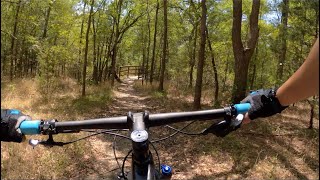
Rocky terrain leads into a quiet hardwood bottomland where you feel like you're truly away from it all.

Access Info

Requires creek crossing to access trail. Exercise caution

Recent Activity on Trail

Past Week
  • 0 rides
  •  
6 Months
  • 7 rides
  • 9 miles avg distance
All
  • 111 rides
  • Last: Jun 21, 2026
c1c2c3c4
January
February
March
April
May
June
July
August
September
October
November
December
update trails status or condition

Flint Rock Loop Trail Reports

statusdatedescription
Mar 9, 2025 @ 9:22am
Mar 9, 2025
Sep 12, 2023 @ 5:45am
Sep 12, 2023
Some branches are starting to overgrow the trail, particularly in some turns. Be careful when riding.
Aug 10, 2023 @ 6:37am
Aug 10, 2023
Mar 26, 2023 @ 4:44am
Mar 26, 2023
It just rained a couple days ago out here and the trail is in great condition. It’s wet in the one spot that is pretty typically wet, of...
Mar 5, 2023 @ 12:45am
Mar 5, 2023
more »
Status:
on Mar 9, 2025
Ideal
Avg: 3.84 (1 votes)
Your vote: 0

view (688)
close
3D
Trail Conditions
  • Unknown
  • Snow Groomed
  • Snow Packed
  • Snow Covered
  • Snow Cover Partial
  • Freeze/thaw Cycle
  • Icy
  • Prevalent Mud
  • Wet
  • Variable
  • Ideal
  • Dry
  • Very Dry
Trail Flow (Ridden Direction)
Trailforks scans users ridelogs to determine the most popular direction each trail is ridden. A good flowing trail network will have most trails flowing in a single direction according to their intension.
The colour categories are based on what percentage of riders are riding a trail in its intended direction.
  • > 96%
  • > 90%
  • > 80%
  • > 70%
  • > 50%
  • < 50%
  • bi-directional trail
  • no data
Trail Last Ridden
Trailforks scans ridelogs to determine the last time a trail was ridden.
  • < 2 days
  • < 1 week
  • < 2 weeks
  • < 1 month
  • < 6 months
  • > 6 months
Trail Ridden Direction
The intended direction a trail should be ridden.
  • Downhill Only
  • Downhill Primary
  • Both Directions
  • Uphill Primary
  • Uphill Only
  • One Direction
Contribute Details
Colors indicate trail is missing specified detail.
  • Description
  • Photos
  • Description & Photos
  • Videos
Trail Popularity ?
Trailforks scans ridelogs to determine which trails are ridden the most in the last 9 months. Trails are compared with nearby trails in the same city region with a possible 25 colour shades. Think of this as a heatmap, more rides = more kinetic energy = warmer colors.
  • most popular
  • popular
  • less popular
  • not popular
ATV/ORV/OHV Filter
Max Vehicle Width
inches
US Cell Coverage
Legend
cell carrier legend

Radar Time
Activity Recordings
Trailforks uses anonymized public activity data. ?
Activity Recordings
Trailforks uses anonymized public activity data. ?
Personal Heatmap
Activity Types
all / none
Options
2
Date range month
Winter Trails
Warning A routing network for winter maps does not exist. Selecting trails using the winter trails layer has been disabled.
Missing Trails
Most Popular
Least Popular
Trails are colored based on popularity. The more popular a trail is, the more red. Less popular trails trend towards green.
Jump Magnitude Heatmap
Heatmap of where riders jump on trails. Zoom in to see individual jumps, click circles to view jump details.
BC Backroad Status

Service Road Atlas is a free to use, community-driven service for viewing and creating reports on the numerous back-country service roads around B.C. and Alberta.

map legend
Slope Aspect
Direction the slope faces
Flat N NE E SE S SW W NW
Trails Deemphasized
Trails are shown in grey.
disable
Only show trails with no bike usage.
Enable
Suggested Layers
Based on selected activity type

    Save the current map location and zoom level as your default home location whenever this page is loaded.

    Save
        Directions to flint-rock-loop trailhead (30.195980, -97.717179)

        Photos

        6 more »
        98 |
        Apr 10, 2021 @ 7:58am
        Apr 10, 2021
        100 |
        Apr 10, 2021 @ 7:58am
        Apr 10, 2021
        88 |
        Apr 10, 2021 @ 7:53am
        Apr 10, 2021
        80 |
        Apr 10, 2021 @ 7:53am
        Apr 10, 2021

        Videos

        1 more »
        Mountain Biking at McKinney Falls State Park...
        11:11 | 254 | Jun 12, 2021 , Austin

        Reviews / Comments

        No reviews yet, be the first to write a review or ask a question.
        Use trail reports to comment on trail conditions.


        We hope you've been enjoying Trailforks!

        Create a FREE account to view trail comments and much more.

        • By toddTF Pro Trailforks & contributors
        • #118885 - 1,615 views

        Frequently Asked Questions About Flint Rock Loop

        Where is Flint Rock Loop located?
        Flint Rock Loop is located in McKinney Falls State Park, Austin, Texas, United States. It is part of the McKinney Falls State Park trail network. The trailhead is located at coordinates 30.19598, -97.71718.
        How hard is Flint Rock Loop?
        Flint Rock Loop is rated as Blue difficulty. The physical rating is Moderate. The average grade is 0.2%. The climb difficulty is rated Blue.
        What is the elevation gain for Flint Rock Loop?
        Flint Rock Loop has 68 ft of elevation gain. The trail has 82 ft of elevation descent. The elevation ranges from 521 ft to 594 ft.
        Is Flint Rock Loop a point to point trail?
        Flint Rock Loop is not a point to point trail. The direction is Both Directions. The trail type is singletrack.

        Hit the Trail

        Open in App

        Get this trail on your phone instantly.
        open trail in app

        Download Trail

        Save to wishlist, Garmin & download.
        save the trail

        Find Related Routes

        Find routes and users activities that include this trail.
        find routes for this trail

        You must enter a description before submitting.