more stats
1,870 ft
Distance
-487 ft
Descent
00:08:44
Avg time
-487 ft
Altitude change
2,121 ft
Altitude min
2,608 ft
Altitude max
2,608 ft
Altitude start
2,123 ft
Altitude end
-26%
Grade
-76.4%
Grade max
-2.1%
Grade min
1,870 ft
Distance down
00:08:44
Avg time

Flying Squirrel Details

  • Activities
    • Mountain Bike
    • E-Bike
  • Riding Area
    Noble Canyon
    Vernon, British Columbia
  • Difficulty Rating
  • Local Popularity
    50 in Mountain Biking [+]
    • 50 in E-Biking
  • Global Ranking
    #104344 in Mountain Biking [+]
    • #83515 in E-Biking
  • Trail Type
    Singletrack
  • Bike Type
    DH, AM
  • Direction
    Downhill Only
    Popular Direction Shown
  • Physical Rating
    Moderate
  • Dogs Allowed
    Yes
  • eBike Allowed
    Yes up to Class 1
  • TTFs on Trail
    Berm, Bridge, Drop, Jump

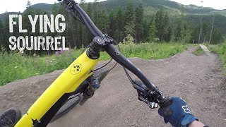
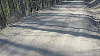
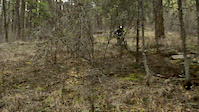
Fast with some wood and dirt jumps, most have rolls but not all, no ride arounds, no gap jumps, . Almost no pedalling or uphill. Access is up forest service road then skid road. Trail bisects skid road several times on way down. Initially built as shuttle/DH trail, but road condition varies, best to pedal up. Watch out for dirt bikes and quads on road up. Trail dries out quickly, can get loose mid-summer.

Local Trail Association

Recent Activity on Trail

Past Week
  • 0 rides
  •  
6 Months
  • 0 rides
  •  
All
  • 27 rides
  • Last: Nov 12, 2025
c1c2c3c4
January
February
March
April
May
June
July
August
September
October
November
December
update trails status or condition

Flying Squirrel Trail Reports

Status:
on Jun 29, 2025
Ideal
Avg: 4.17 (5 votes)
Your vote: 0

view (230)
close
3D
Trail Conditions
  • Unknown
  • Snow Groomed
  • Snow Packed
  • Snow Covered
  • Snow Cover Partial
  • Freeze/thaw Cycle
  • Icy
  • Prevalent Mud
  • Wet
  • Variable
  • Ideal
  • Dry
  • Very Dry
Trail Flow (Ridden Direction)
Trailforks scans users ridelogs to determine the most popular direction each trail is ridden. A good flowing trail network will have most trails flowing in a single direction according to their intension.
The colour categories are based on what percentage of riders are riding a trail in its intended direction.
  • > 96%
  • > 90%
  • > 80%
  • > 70%
  • > 50%
  • < 50%
  • bi-directional trail
  • no data
Trail Last Ridden
Trailforks scans ridelogs to determine the last time a trail was ridden.
  • < 2 days
  • < 1 week
  • < 2 weeks
  • < 1 month
  • < 6 months
  • > 6 months
Trail Ridden Direction
The intended direction a trail should be ridden.
  • Downhill Only
  • Downhill Primary
  • Both Directions
  • Uphill Primary
  • Uphill Only
  • One Direction
Contribute Details
Colors indicate trail is missing specified detail.
  • Description
  • Photos
  • Description & Photos
  • Videos
Trail Popularity ?
Trailforks scans ridelogs to determine which trails are ridden the most in the last 9 months. Trails are compared with nearby trails in the same city region with a possible 25 colour shades. Think of this as a heatmap, more rides = more kinetic energy = warmer colors.
  • most popular
  • popular
  • less popular
  • not popular
ATV/ORV/OHV Filter
Max Vehicle Width
inches
US Cell Coverage
Legend
cell carrier legend

Radar Time
Activity Recordings
Trailforks uses anonymized public activity data. ?
Activity Recordings
Trailforks uses anonymized public activity data. ?
Personal Heatmap
Activity Types
all / none
Options
2
Date range month
Winter Trails
Warning A routing network for winter maps does not exist. Selecting trails using the winter trails layer has been disabled.
Missing Trails
Most Popular
Least Popular
Trails are colored based on popularity. The more popular a trail is, the more red. Less popular trails trend towards green.
Jump Magnitude Heatmap
Heatmap of where riders jump on trails. Zoom in to see individual jumps, click circles to view jump details.
BC Backroad Status

Service Road Atlas is a free to use, community-driven service for viewing and creating reports on the numerous back-country service roads around B.C. and Alberta.

map legend
Slope Aspect
Direction the slope faces
Flat N NE E SE S SW W NW
Trails Deemphasized
Trails are shown in grey.
disable
Only show trails with no bike usage.
Enable
Suggested Layers
Based on selected activity type

    Save the current map location and zoom level as your default home location whenever this page is loaded.

    Save
        Directions to flying-squirrel trailhead (50.268240, -119.080720)

        Photos

        31 more »
        90 |
        Oct 6, 2023 @ 1:20pm
        Oct 6, 2023
        91 |
        Oct 6, 2023 @ 1:20pm
        Oct 6, 2023
        84 |
        Oct 6, 2023 @ 1:20pm
        Oct 6, 2023
        134 |
        Sep 27, 2023 @ 4:39pm
        Sep 27, 2023

        Videos

        5 more »
        Flying Squirrel (Self Filmed Full Trail)
        2:09 | 525 | Apr 19, 2021 , Vernon
        Flying Squirrel (Gimbal POV)
        2:15 | 689 | Jun 27, 2020 , Vernon
        flying squirrel pov
        0:24 | 122 | Apr 17, 2021 , Vernon
        0:05 | 266 | May 15, 2017 , Vernon

        Routes with this trail

        The Big 6 Featured
        5.0 82 miles 11,717 ft 32 Point to Point
        This is an epic ride, Ed Callenders "EdMondo" route completed in 2019 has been updated to include the...
        5.0 82 miles 9,995 ft 91
        100% self supported, no lifts, no shuttles. Let's play.
        79 miles 10,654 ft 102 Point to Point
        Connect all the networks in the Vernon area, exact trails can be changed but must ride entire route, no...

        1 Review & Comments


        We hope you've been enjoying Trailforks!

        Create a FREE account to view trail comments and much more.

        • By ThatDanTF Pro & contributors
        • #33046 - 5,832 views

        Frequently Asked Questions About Flying Squirrel

        Where is Flying Squirrel located?
        Flying Squirrel is located in Noble Canyon, Vernon, British Columbia, Canada. It is part of the Noble Canyon trail network. The trailhead is located at coordinates 50.26824, -119.08072.
        How hard is Flying Squirrel?
        Flying Squirrel is rated as Black Diamond difficulty. The physical rating is Moderate. The average grade is 26%.
        What is the elevation gain for Flying Squirrel?
        The trail has 487 ft of elevation descent. The elevation ranges from 2,121 ft to 2,608 ft.
        Is Flying Squirrel a point to point trail?
        Yes, Flying Squirrel is a point to point trail. The direction is Downhill Only. The trail type is singletrack.

        Hit the Trail

        Open in App

        Get this trail on your phone instantly.
        open trail in app

        Download Trail

        Save to wishlist, Garmin & download.
        save the trail

        Find Related Routes

        Find routes and users activities that include this trail.
        find routes for this trail

        You must enter a description before submitting.