1,135 ft
Distance
-108 ft
Descent
00:02:04
Avg time

Fruit Flow Expert Details

  • Activities
    • Mountain Bike
  • Riding Area
    Fruit Loops
    Fruit Heights, Utah
  • Difficulty Rating
  • Voted Difficulty
    Black Diamond (1 vote)
  • Trail Type
    Singletrack
  • Bike Type
    AM
  • Direction
    Downhill Only
    Popular direction shown
  • eBike Allowed
  • TTFs on Trail
    Berm, Drop, Jump, Gap Jump, Rock Face, Rock Garden
  • Global Ranking
    #5083 in Mountain Biking
  • Local Popularity
    80 in Mountain Biking

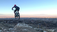
The signage indicates that this trail is a double diamond, but most of it is not. There are several little rock drops and senders and if you hit it fast there are several small gaps, but you can roll everything. Near the bottom is one big sender with a gap onto a nice steep and smooth runout. This is the only real double diamond feature, but there is a smaller rock sender or you can roll down the gully to the left. This is a great trail to do multiple laps until you get all the features and double ups dialed in.

Traditionally Indigenous Territory
More Stats for Fruit Flow Expert mountain bike trail trail
  • Altitude change
    -108 ft
  • Altitude min
    4,722 ft
  • Altitude max
    4,830 ft
  • Altitude start
    4,830 ft
  • Altitude end
    4,721 ft
  • Grade
    -9.5%
  • Grade max
    -20.9%
  • Grade min
    -3%
  • Distance down
    1,135 ft
  • Avg time
    00:02:04
  • Avg reverse time
    00:11:27
  • view trail stats
Status:
on Mar 1, 2025
Ideal
Avg: 4.04 (15 votes)
Your vote: 0

view (5,978)
close
3D
Trail Conditions
  • Unknown
  • Snow Groomed
  • Snow Packed
  • Snow Covered
  • Snow Cover Partial
  • Freeze/thaw Cycle
  • Icy
  • Prevalent Mud
  • Wet
  • Variable
  • Ideal
  • Dry
  • Very Dry
Trail Flow (Ridden Direction)
Trailforks scans users ridelogs to determine the most popular direction each trail is ridden. A good flowing trail network will have most trails flowing in a single direction according to their intension.
The colour categories are based on what percentage of riders are riding a trail in its intended direction.
  • > 96%
  • > 90%
  • > 80%
  • > 70%
  • > 50%
  • < 50%
  • bi-directional trail
  • no data
Trail Last Ridden
Trailforks scans ridelogs to determine the last time a trail was ridden.
  • < 2 days
  • < 1 week
  • < 2 weeks
  • < 1 month
  • < 6 months
  • > 6 months
Trail Ridden Direction
The intended direction a trail should be ridden.
  • Downhill Only
  • Downhill Primary
  • Both Directions
  • Uphill Primary
  • Uphill Only
  • One Direction
Contribute Details
Colors indicate trail is missing specified detail.
  • Description
  • Photos
  • Description & Photos
  • Videos
Trail Popularity ?
Trailforks scans ridelogs to determine which trails are ridden the most in the last 9 months. Trails are compared with nearby trails in the same city region with a possible 25 colour shades. Think of this as a heatmap, more rides = more kinetic energy = warmer colors.
  • most popular
  • popular
  • less popular
  • not popular
ATV/ORV/OHV Filter
Max Vehicle Width
inches
US Cell Coverage
Legend
cell carrier legend

Radar Time
x Activity Recordings
Trailforks users anonymized public ridelogs from the past 6 months.
  • mountain biking recent
  • mountain biking (>6 month)
  • hiking (1 year)
  • moto (1 year)
Activity Recordings
Trailforks users anonymized public skilogs from the past 12 months.
  • Downhill Ski
  • Backcountry Ski
  • Nordic Ski
  • Snowmobile
Winter Trails
Warning A routing network for winter maps does not exist. Selecting trails using the winter trails layer has been disabled.
x Missing Trails
Most Popular
Least Popular
Trails are colored based on popularity. The more popular a trail is, the more red. Less popular trails trend towards green.
Jump Magnitude Heatmap
Heatmap of where riders jump on trails. Zoom in to see individual jumps, click circles to view jump details.
Trails Deemphasized
Trails are shown in grey.
disable
Only show trails with NO bikes.
enable

Save the current map location and zoom level as your default home location whenever this page is loaded.

Save
      Directions to fruit-flow-expert trailhead (41.017640, -111.895910)
      update trails status or condition

      Fruit Flow Expert Trail Reports

      Recent Ridelog Activity on Trail

      Past Week
      • 1 rides
      • 20 miles avg distance
      6 Months
      • 18 rides
      • 17 miles avg distance
      All
      • 303 rides
      • Last: Mar 17, 2025

      Photos

      more »
      122 |
      Jan 23, 2022 @ 1:12pm
      Jan 23, 2022
      149 |
      Jan 23, 2022 @ 1:12pm
      Jan 23, 2022
      125 |
      Jan 23, 2022 @ 1:12pm
      Jan 23, 2022
      118 |
      Jan 22, 2022 @ 12:49pm
      Jan 22, 2022

      5 Reviews & Comments


      We hope you've been enjoying Trailforks!

      Create a FREE account to view trail comments and much more.

      Videos

      more »
      Fruit Loop Bike Park- Fruit Flow Expert
      1124 | Mar 19, 2019 , Fruit Heights
      Fruit Loops
      0:18 | 818 | Nov 10, 2019 , Fruit Heights
      fallin fruit
      0:14 | 937 | Apr 17, 2019 , Fruit Heights
      • By toddTF Pro Trailforks & contributors
      • #157551 - 3,870 views

      You must enter a description before submitting.