more stats
3,045 ft
Distance
-502 ft
Descent
00:06:53
Avg time
-502 ft
Altitude change
1,476 ft
Altitude min
1,978 ft
Altitude max
1,978 ft
Altitude start
1,476 ft
Altitude end
-16.5%
Grade
-55.1%
Grade max
-1.8%
Grade min
3,012 ft
Distance down
33 ft
Distance flat
00:06:53
Avg time

Ghoster Details

  • Activities
    • Mountain Bike
  • Riding Area
  • Difficulty Rating
  • Local Popularity
    45 in Mountain Biking
  • Trail Type
    Singletrack
  • Bike Type
    DH, AM
  • Direction
    Downhill Only
    Popular Direction Shown
  • eBike Allowed
    Yes up to Class 1
  • TTFs on Trail
    Rock Face, Rock Garden
  • Year Opened
    2021
  • Land Owner
    Mt Abram Ski Area & Bike Park

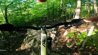
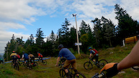
A hand-built trail from the top of Mt. Abram that descends down to the west-side bike park. Trail is significantly steeper than any of the lower trails on the west-side, with plentiful lengths of ledge giving the terrain a unique feel.

Access Info

At the moment, access to the top of Mt. Abram is up the access road.

Bike Park

Recent Activity on Trail

Past Week
  • 0 rides
  •  
6 Months
  • 0 rides
  •  
All
  • 101 rides
  • Last: Jun 13, 2026
c1c2c3c4
January
February
March
April
May
June
July
August
September
October
November
December
update trails status or condition

Ghoster Trail Reports

statusdatedescription
Apr 5, 2025 @ 8:15am
Apr 5, 2025
Jul 23, 2023 @ 6:16am
Jul 23, 2023
Mostly dry. Improvements to the trail are apparent from last season. Lots of fun. Some deeper ruts to keep an eye out for, but even they are fun...
Nov 1, 2022 @ 6:20am
Nov 1, 2022
reporter
Jul 24, 2022 @ 6:29am
Jul 24, 2022
Considering that this trail sees a lot of braking, it's in great shape.
more »
Status:
on Apr 5, 2025
Avg: 4.24 (3 votes)
Your vote: 0

view (866)
close
3D
Trail Conditions
  • Unknown
  • Snow Groomed
  • Snow Packed
  • Snow Covered
  • Snow Cover Partial
  • Freeze/thaw Cycle
  • Icy
  • Prevalent Mud
  • Wet
  • Variable
  • Ideal
  • Dry
  • Very Dry
Trail Flow (Ridden Direction)
Trailforks scans users ridelogs to determine the most popular direction each trail is ridden. A good flowing trail network will have most trails flowing in a single direction according to their intension.
The colour categories are based on what percentage of riders are riding a trail in its intended direction.
  • > 96%
  • > 90%
  • > 80%
  • > 70%
  • > 50%
  • < 50%
  • bi-directional trail
  • no data
Trail Last Ridden
Trailforks scans ridelogs to determine the last time a trail was ridden.
  • < 2 days
  • < 1 week
  • < 2 weeks
  • < 1 month
  • < 6 months
  • > 6 months
Trail Ridden Direction
The intended direction a trail should be ridden.
  • Downhill Only
  • Downhill Primary
  • Both Directions
  • Uphill Primary
  • Uphill Only
  • One Direction
Contribute Details
Colors indicate trail is missing specified detail.
  • Description
  • Photos
  • Description & Photos
  • Videos
Trail Popularity ?
Trailforks scans ridelogs to determine which trails are ridden the most in the last 9 months. Trails are compared with nearby trails in the same city region with a possible 25 colour shades. Think of this as a heatmap, more rides = more kinetic energy = warmer colors.
  • most popular
  • popular
  • less popular
  • not popular
ATV/ORV/OHV Filter
Max Vehicle Width
inches
US Cell Coverage
Legend
cell carrier legend

Radar Time
Activity Recordings
Trailforks uses anonymized public activity data. ?
Activity Recordings
Trailforks uses anonymized public activity data. ?
Personal Heatmap
Activity Types
all / none
Options
2
Date range month
Winter Trails
Warning A routing network for winter maps does not exist. Selecting trails using the winter trails layer has been disabled.
Missing Trails
Most Popular
Least Popular
Trails are colored based on popularity. The more popular a trail is, the more red. Less popular trails trend towards green.
Jump Magnitude Heatmap
Heatmap of where riders jump on trails. Zoom in to see individual jumps, click circles to view jump details.
BC Backroad Status

Service Road Atlas is a free to use, community-driven service for viewing and creating reports on the numerous back-country service roads around B.C. and Alberta.

map legend
Slope Aspect
Direction the slope faces
Flat N NE E SE S SW W NW
Trails Deemphasized
Trails are shown in grey.
disable
Only show trails with no bike usage.
Enable
Suggested Layers
Based on selected activity type

    Save the current map location and zoom level as your default home location whenever this page is loaded.

    Save
        Directions to ghoster trailhead (44.369660, -70.713200)

        Photos

        3 more »
        270 |
        Sep 29, 2022 @ 6:26pm
        Sep 29, 2022
        210 |
        Sep 29, 2022 @ 6:22pm
        Sep 29, 2022
        308 |
        Sep 29, 2022 @ 6:26pm
        Sep 29, 2022

        Videos

        3 more »
        UNTIL SUNDOWN | Ben Farrell x Enduro
        2:59 | 225 | Nov 11, 2022 , Bethel
        ghoster to yellow jacket highlights
        0:00 | 212 | Oct 10, 2022 , Bethel
        Trans New England Party Train
        3:47 | 253 | Oct 21, 2021 , Bethel

        1 Review & Comments


        We hope you've been enjoying Trailforks!

        Create a FREE account to view trail comments and much more.

        • By CalebClarkeTF Pro & contributors
        • #466129 - 1,044 views

        Frequently Asked Questions About Ghoster

        Where is Ghoster located?
        Ghoster is located in Mount Abram Ski Area & Bike Park, Bethel, Maine, United States. It is part of the Mount Abram Ski Area & Bike Park trail network. The trailhead is located at coordinates 44.36966, -70.7132.
        How hard is Ghoster?
        Ghoster is rated as Black Diamond difficulty. The average grade is 16.5%.
        What is the elevation gain for Ghoster?
        The trail has 502 ft of elevation descent. The elevation ranges from 1,476 ft to 1,978 ft.
        Is Ghoster a point to point trail?
        Yes, Ghoster is a point to point trail. The direction is Downhill Only. The trail type is singletrack.

        Hit the Trail

        Open in App

        Get this trail on your phone instantly.
        open trail in app

        Download Trail

        Save to wishlist, Garmin & download.
        save the trail

        Find Related Routes

        Find routes and users activities that include this trail.
        find routes for this trail

        You must enter a description before submitting.