3.5 miles
Distance
420 ft
Climb
-473 ft
Descent
00:28:18
Avg time
Supporters, Builders, Maintainers & Land Managers of Goosebumps Trail
BLMLand Manager
Goosebumps Details
-
Activities
- Mountain Bike
- Hike
- Trail Running
-
Riding AreaHurricane Cliffs
Hurricane, Utah -
Difficulty Rating
-
Trail TypeSingletrack
-
DirectionBoth Directions
-
Dogs AllowedYes
-
eBike Allowed
-
Global Ranking
-
Local Popularity85 in Mountain Biking [+]
- 5 in Trail Running
- 80 in Hiking
-
Land OwnerBureau of Land Management
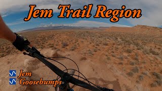
An awesome flowy trail with fun drops and hills. There are 2 trails splits with an easy and intermediate line, the easy line going around the hill drops and the intermediate line taking a fast fun line directly down the hills. The trail ends on an access road, however there is a continuation on an alt line which takes some small jumps and bumps down to the middle parking lot next to Sheep Bridge Road.
Local Trail Association
-
Please consider joining or donating to the local trail association to supportdonate to earn trail karma!
trail development & maintenance.
Traditionally Indigenous Territory
More Stats for Goosebumps mountain bike trail trail
-
Altitude change-53 ft
-
Altitude min3,920 ft
-
Altitude max4,038 ft
-
Altitude start4,019 ft
-
Altitude end3,966 ft
-
Grade-0.285%
-
Grade max-61.677%
-
Grade min56.418%
-
Distance climb1 mile
-
Distance down2 miles
-
Distance flat2,215 ft
-
Avg time00:28:18
-
Avg reverse time00:33:00
- view trail stats
close
3D
Trail Conditions
- Unknown
- Snow Groomed
- Snow Packed
- Snow Covered
- Snow Cover Inadequate
- Freeze/thaw Cycle
- Icy
- Prevalent Mud
- Wet
- Variable
- Ideal
- Dry
- Very Dry
Trail Flow (Ridden Direction)
Trailforks scans users ridelogs to determine the most popular direction each trail is ridden. A good flowing trail network will have most trails flowing in a single direction according to their intension.
The colour categories are based on what percentage of riders are riding a trail in its intended direction.
- > 96%
- > 90%
- > 80%
- > 70%
- > 50%
- < 50%
- bi-directional trail
- no data
Trail Last Ridden
Trailforks scans ridelogs to determine the last time a trail was ridden.
- < 2 days
- < 1 week
- < 2 weeks
- < 1 month
- < 6 months
- > 6 months
Trail Ridden Direction
The intended direction a trail should be ridden.
- Downhill Only
- Downhill Primary
- Both Directions
- Uphill Primary
- Uphill Only
- One Direction
Contribute Details
Colors indicate trail is missing specified detail.
- Description
- Photos
- Description & Photos
- Videos
Trail Popularity ?
Trailforks scans ridelogs to determine which trails are ridden the most in the last 9 months.
Trails are compared with nearby trails in the same city region with a possible 25 colour shades.
Think of this as a heatmap, more rides = more kinetic energy = warmer colors.
- most popular
- popular
- less popular
- not popular
ATV/ORV/OHV Filter
Max Vehicle Width
inches
Radar Time
x
Activity Recordings
Trailforks users anonymized public ridelogs from the past 6 months.
- mountain biking recent
- mountain biking (>6 month)
- hiking (1 year)
- moto (1 year)
Activity Recordings
Trailforks users anonymized public skilogs from the past 12 months.
- Downhill Ski
- Backcountry Ski
- Nordic Ski
- Snowmobile
Winter Trails
Warning
A routing network for winter maps does not exist. Selecting trails using the winter trails layer has been disabled.
x
Missing Trails
Most Popular
Least Popular
Trails are colored based on popularity. The more popular a trail is, the more red. Less popular trails trend towards green.
Jump Magnitude Heatmap
Heatmap of where riders jump on trails. Zoom in to see individual jumps, click circles to view jump details.
Trails Deemphasized
Trails are shown in grey.
Only show trails with NO bikes.
Save the current map location and zoom level as your default home location whenever this page is loaded.
Save
Directions to goosebumps trailhead
(37.151830, -113.251850)
update trails status or condition
Goosebumps Trail Reports
view all reports »
Recent Ridelog Activity on Trail
Past Week
- 9 rides
- 13 miles avg distance
6 Months
- 247 rides
- 14 miles avg distance
All
- 1,843 rides
- Last: Oct 1, 2023
Photos
more »
Routes with this trail
more »
We hope you've been enjoying Trailforks!
Create a FREE account to view trail comments and much more.
Videos
more »
youtuber

16:02 |
519 |
Apr 5, 2019 , Hurricane
Nearby Trails
- Connector 7 ft
- Jem 7 ft
- Goosebumps A-line 2,700 ft
- Connector 4,072 ft
- Sheep Bridge Road 4,196 ft
- By todd
Trailforks & contributors
- #9349 - 5,568 views
- subscribe
- login to download gpx or kml files.