close
-
Layers w
- Weather Layers
- Pro
- Pro
- Pro
- Pro
- Pro
- Pro
- More Layers
- Pro
- Pro
- Pro
- Pro
-
Upgrade to

3D
Trail Conditions
- Unknown
- Snow Groomed
- Snow Packed
- Snow Covered
- Snow Cover Partial
- Freeze/thaw Cycle
- Icy
- Prevalent Mud
- Wet
- Variable
- Ideal
- Dry
- Very Dry
Trail Flow (Ridden Direction)
Trailforks scans users ridelogs to determine the most popular direction each trail is ridden. A good flowing trail network will have most trails flowing in a single direction according to their intension.
The colour categories are based on what percentage of riders are riding a trail in its intended direction.
The colour categories are based on what percentage of riders are riding a trail in its intended direction.
- > 96%
- > 90%
- > 80%
- > 70%
- > 50%
- < 50%
- bi-directional trail
- no data
Trail Last Ridden
Trailforks scans ridelogs to determine the last time a trail was ridden.
- < 2 days
- < 1 week
- < 2 weeks
- < 1 month
- < 6 months
- > 6 months
Trail Ridden Direction
The intended direction a trail should be ridden.
- Downhill Only
- Downhill Primary
- Both Directions
- Uphill Primary
- Uphill Only
- One Direction
Contribute Details
Colors indicate trail is missing specified detail.
- Description
- Photos
- Description & Photos
- Videos
Trail Popularity ?
Trailforks scans ridelogs to determine which trails are ridden the most in the last 9 months.
Trails are compared with nearby trails in the same city region with a possible 25 colour shades.
Think of this as a heatmap, more rides = more kinetic energy = warmer colors.
- most popular
- popular
- less popular
- not popular
ATV/ORV/OHV Filter
Max Vehicle Width
inches
US Cell Coverage
Legend

Radar Time
Activity Recordings
Trailforks uses anonymized public activity data.
?
Activity Recordings
Trailforks uses anonymized public activity data.
?
Personal Heatmap
▶
Activity Types
all
/
none
▶
Options
2
Date range
month
–
Winter Trails
Warning
A routing network for winter maps does not exist. Selecting trails using the winter trails layer has been disabled.
Missing Trails
Most Popular
Least Popular
Trails are colored based on popularity. The more popular a trail is, the more red. Less popular trails trend towards green.
Jump Magnitude Heatmap
Heatmap of where riders jump on trails. Zoom in to see individual jumps, click circles to view jump details.
BC Backroad Status
![map legend]()
Service Road Atlas is a free to use, community-driven service for viewing and creating reports on the numerous back-country service roads around B.C. and Alberta.

Slope Aspect
Direction the slope faces
Trails Deemphasized
Trails are shown in grey.
Only show trails with no bike usage.
Suggested Layers
Based on selected activity type
Save the current map location and zoom level as your default home location whenever this page is loaded.
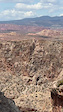
SaveThis expansive trail system was planned with mountain biking in mind and currently includes nearly 40 miles of beginner and intermediate trails. The iconic scenery and flowing singletrack that define the area attract visitors from around the around.
The trail system is defined by La Verkin and Hurricane, UT immediately to the west, UT State Route 9 as the northern boundary, and the sheer flanks of Gooseberry Mesa looming to the east.
Numerous trailheads and access points along UT State Route 59 as well as Sheep Bridge Road provide unlimited opportunity for creative loops and variety for trail users. Please see Directions for recommended day-use parking.
Camping throughout Hurricane Cliffs is limited to 56 Designated Dispersed Sites that were implemented to protect the expansive views and scenic integrity of the area.
Each official site contains a numbered placard and metal fire ring. Camping outside of official, designated sites is prohibited.
All sites are typically accessible by any medium clearance vehicle.
Camping on BLM Lands is allowed for a period not to exceed 14 days within a 28 consecutive day period.
source: BLM | Hurricane Cliffs
AKA: Jem trail
Land Manager: Bureau of Land Management
 google parking directions
Links
Activities Click to view
- Mountain Bike
35 trails
- E-Bike
6 trails
- Horse
4 trails
- Hike
39 trails
- Trail Running
39 trails
- Dirtbike/Moto
2 trails
Region Details
- 9
- 1
- 9
- 10
- 6
Region Status
Open as of Jul 1, 2026Stats
- Avg Trail Rating
- Trails (view details)
- 40
- Trails Mountain Bike
- 35
- Trails E-Bike
- 6
- Trails Gravel Bike
- 11
- Trails Adaptive Bike
- 13
- Trails Winter Fat Bike
- 1
- Trails Horse
- 4
- Trails Hike
- 39
- Trails Trail Running
- 39
- Trails Dirtbike/Moto
- 2
- Trails ATV/ORV/OHV
- 1
- Total Distance
- 68 miles
- Total Descent
- 7,503 ft
- Total Vertical
- 1,319 ft
- Highest Trailhead
- 4,323 ft
- Reports
- 1,400
- Photos
- 491
- Ridden Counter
- 68,238
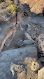
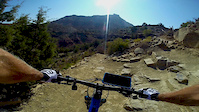
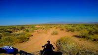
Popular Hurricane Cliffs Mountain Biking Trails
• 100 ★ 4.0 • 448 ft • 4 ft • 5,267 •
Tight loose switchbacks, once navigated you can hit the bottom fast and let her rip
• 100 ★ 4.3 • 2,762 ft • 0 ft • 5,001 •
This is the continuation of the Downhill only section of that takes you through a sandy wash. After you drop off the sketchy canyon edge, you rip down through the high walls of the wash. It moves fast and fun until you reach the...
• 100 ★ 4.1 • 1,893 ft • 0 ft • 4,709 •
Can't beat the view from the top of the trail. This entry section is pretty simple and fast. The trail quickly hits an intimidating technical section (noted in the red) but it is totally rideable. This section is Downhill only from the...
• 100 ★ 4.1 • 2,415 ft • 28 ft • 4,152 •
This the downhill only section that starts off at the parking lot and takes you to the road. Smooth winding singletrack with some really interesting shale rock formations and mini-cliffs that you ride next to. This part can flow pretty...
• 90 ★ 3.9 • 4 miles • 67 ft • 3,241 •
This section of the trail is amazing. The whole ride down is full of fast flowing turns. There are a couple of technical sections but nothing to stress about. Definitely worth the short climb... and definitely worth doing more than one lap!
• 95 ★ 3.6 • 1 mile • 0 ft • 2,951 •
Fun ups and downs in this mostly smooth but fast track. The trail has different optional sections that offer a bit of tech or just a faster drop. Most the trail you are surrounded by cryptobiotic soil, hence the name.
• 95 ★ 4.0 • 4 miles • 502 ft • 2,803 •
New extension to the trails. This trail was built and designed as a climbing trail to access the top of the trail (Southern most end also the highest point). There is a section of climb that is bench cut leaving little to no room for...
Hurricane Cliffs Mountain Bike Routes
★ 4.7 • 11 miles • 817 ft • 1 • Loop •
This is a great family friendly route that is a good way to introduce your kids or new rider to the fun of...
★ 3.0 • 24 miles • 2,223 ft • 8 •
This is a big loop! There are lots of punchy ups and some steady climbs, so don't think that it's a mellow...
★ 5.0 • 11 miles • 775 ft • 5 • Loop •
Starting at the road where first crosses, ride southeast on and climb to the top of the mesa and hook a...
★ 5.0 • 8 miles • 591 ft • 5 • Loop •
This is the 2017 Intermountain Cup Cactus Hugger Race route for one lap.
★ 5.0 • 16 miles • 1,322 ft • 20 •
This is our planned medium length (~13 miles) loop in the Hurricane cliffs area. Hitting all of with an...
★ 2.7 • 13 miles • 1,022 ft • 2 • Loop •
This route takes you up so that you can extend your distance when riding down . This provides some good...
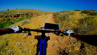
Photos of Hurricane Cliffs Mountain Bike
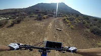
Videos of Hurricane Cliffs Mountain Bike
trail: Hurricane Rim
0:47 |
2 |
Apr 27, 2026
trail: Jem
0:06 |
567 |
Dec 27, 2022

trail: Jem Road
0:05 |
|
Feb 24, 2022
trail: Jem Road
6:09 |
95 |
Sep 25, 2020
trail: Jem Road
8:55 |
35 |
Sep 25, 2020

trail: Jem Road
11:42 |
31 |
Sep 25, 2020
trail: Jem Road
7:06 |
30 |
Sep 25, 2020
trail: Jem Road
0:46 |
70 |
Sep 23, 2020
Recent Trail Reports
| status | trail | date | condition | info | user |
|---|---|---|---|---|---|
| JEM (DH) | Jul 1, 2026 @ 8:15am (America/Denver) Jul 1, 2026 | Very Dry | UtahJohn TRAILFORKS | ||
| Jem | Jul 1, 2026 @ 8:15am (America/Denver) Jul 1, 2026 | Very Dry | UtahJohn TRAILFORKS | ||
| Jem | Jul 1, 2026 @ 8:15am (America/Denver) Jul 1, 2026 | Very Dry | UtahJohn TRAILFORKS | ||
| Steak Knife | Jul 1, 2026 @ 8:15am (America/Denver) Jul 1, 2026 | Very Dry | UtahJohn TRAILFORKS | ||
| Jem Road | Jul 1, 2026 @ 8:15am (America/Denver) Jul 1, 2026 | Very Dry | UtahJohn TRAILFORKS | ||
| Goosebumps A-Line | Jul 1, 2026 @ 8:15am (America/Denver) Jul 1, 2026 | Very Dry | UtahJohn TRAILFORKS | ||
| Goosebumps | Jul 1, 2026 @ 8:15am (America/Denver) Jul 1, 2026 | Very Dry | UtahJohn TRAILFORKS | ||
| Goosebumps A-Line | Jul 1, 2026 @ 8:15am (America/Denver) Jul 1, 2026 | Very Dry | UtahJohn TRAILFORKS | ||
| Cryptobionic | May 30, 2026 @ 8:00am (America/Phoenix) May 30, 2026 | Ideal | sdcnaples | ||
| Carne Asada | May 2, 2026 @ 10:20am (America/Denver) May 2, 2026 | Very Dry | frizbee-luke |
Activity Feed
| username | action | type | title | date |
|---|---|---|---|---|
| dustytreads42 | ridden | trail | activity #98589433 | Jul 6, 2026 @ 11:40am 3 days |
| UtahJohn | add | report | activity #98220895 and 7 more | Jul 1, 2026 @ 12:51pm Jul 1, 2026 |
| UtahJohn | update | trail | activity #98220741 | Jul 1, 2026 @ 12:48pm Jul 1, 2026 |
| UtahJohn | difficultyvote | trail | activity #98220570 | Jul 1, 2026 @ 12:46pm Jul 1, 2026 |
| UtahJohn | vote | trail | activity #98220559 | Jul 1, 2026 @ 12:46pm Jul 1, 2026 |
Recent Comments
| username | type | title | comment | date |
|---|---|---|---|---|
| trail | Wonderful trail with amazing views. Most of it... | Apr 10, 2026 @ 8:42pm Apr 10, 2026 | ||
| trail | This trail climbs really well. It’s a little... | Apr 10, 2026 @ 8:40pm Apr 10, 2026 | ||
| report | I | Apr 4, 2026 @ 2:14pm Apr 4, 2026 | ||
| trail | Ride it reverse of what trail forks shows.... | Feb 25, 2026 @ 6:53pm Feb 25, 2026 | ||
| trail | And link to more cowbells for an amazing view... | Nov 14, 2025 @ 6:50pm Nov 14, 2025 |
Nearby Areas
| name | distance | ||||
|---|---|---|---|---|---|
| Confluence Park | 4 | 5 | 2.4 km | ||
| Gooseberry Mesa | 3 | 8 | 5 | 4.7 km | |
| Red Cliffs BLM National Conservation Area-Sand Cove Unit | 1 | 2 | 2 | 6 km | |
| Guacamole | 5 | 4 | 7.5 km | ||
| Little Creek Mountain | 6 | 1 | 7.6 km |
Local Badges
-

Completionist5 awarded
Activity Type Stats
| activitytype | trails | distance | descent | descent distance | total vertical | rating | global rank | state rank | photos | reports | routes | ridelogs |
|---|---|---|---|---|---|---|---|---|---|---|---|---|
| Mountain Bike | 35 | 63 miles | 6,650 ft | 29 miles | 1,319 ft | #287 | #105 | 461 | 1,398 | 22 | 27,418 | |
| E-Bike | 6 | 22 miles | 2,408 ft | 12 miles | 1,158 ft | #4,399 | #1,228 | 1,167 | 1 | 1,705 | ||
| Gravel Bike | 11 | 19 miles | 1,342 ft | 8 miles | 843 ft | #167 | #68 | 528 | 23 | |||
| Adaptive Bike | 13 | 24 miles | 1,844 ft | 13 miles | 873 ft | #167 | #68 | 2 | 610 | 1 | 2 | |
| Winter Fat Bike | 1 | 4 miles | 23 ft | 2,211 ft | 479 ft | #167 | #68 | 179 | 1 | |||
| Horse | 4 | 4 miles | 223 ft | 1 mile | 1,211 ft | #2,276 | #1,243 | 273 | 3 | |||
| Hike | 39 | 56 miles | 6,060 ft | 26 miles | 1,319 ft | #1,698 | 22 | 1,397 | 578 | |||
| Trail Running | 39 | 56 miles | 6,060 ft | 26 miles | 1,319 ft | #3,161 | 1,397 | 247 | ||||
| Dirtbike/Moto | 2 | 13 miles | 1,444 ft | 6 miles | 502 ft | #722 | #266 | 5 | 274 | 15 | ||
| ATV/ORV/OHV | 1 | 2 miles | 3 ft | 466 ft | 79 ft | 1 | 235 | 37 |
Frequently Asked Questions About Hurricane Cliffs
▼
What are the highest rated mountain biking trails in Hurricane Cliffs?
The highest rated mountain biking trails in Hurricane Cliffs are:
- JEM (DH) (4.3/5)
- Goosebumps A-Line (4.3/5)
- Steak Knife (4.2/5)
- Goosebumps A-Line (4.2/5)
- More Cowbell (4.1/5)
▼
What is the best time of the year to ride in Hurricane Cliffs?
Based on ride log data, the most popular months to ride in Hurricane Cliffs are:
- October (406 activities)
- April (378 activities)
- November (346 activities)
▼
Where can I park to ride in Hurricane Cliffs?
There are 9 parking locations listed in Hurricane Cliffs. The most popular parking spots are: View all parking and trailhead locations on the map to plan your visit.
▼
What is the longest trail in Hurricane Cliffs?
The longest trail in Hurricane Cliffs is Toquerville Twister at 12.3 miles. View all trails sorted by distance.
Activities
Trails
Points of Interest
- Hurricane Cliffs Campsite 21 Camping
- Overlook Viewpoint
- Hurricane Cliffs Campsite 14 Camping
- Hurricane Cliffs Campsite 35 Camping
- Hurricane Cliffs Campsite 18 Camping
- Hurricane Cliffs Campsite 16 Camping
- Hurricane Cliffs Campsite 44 Camping
- Hurricane Cliffs Campsite 1 Camping
- Hurricane Cliffs Campsite 48 Camping
- Hurricane Cliffs Campsite 47 Camping
- By canadaka
 Trailforks & contributors
 - Admins: SUBA
- #16114 - 23,859 views
- hurricane cliffs activity log | embed map of Hurricane Cliffs mountain bike trails | hurricane cliffs mountain biking points of interest
Downloading of trail gps tracks in kml & gpx formats is enabled for Hurricane Cliffs.
You must login to download files.