more stats
4,327 ft
Distance
14 ft
Climb
-9 ft
Descent
00:06:01
Avg time
5 ft
Altitude change
628 ft
Altitude min
639 ft
Altitude max
633 ft
Altitude start
636 ft
Altitude end
0.1%
Grade
-3.9%
Grade max
3.8%
Grade min
745 ft
Distance climb
856 ft
Distance down
2,513 ft
Distance flat
00:06:01
Avg time

GRBP Loop Details

  • Activities
    • Mountain Bike
  • Riding Area
    Grand Rapids Bike Park
    Grand Rapids, Michigan
  • Difficulty Rating
  • Local Popularity
    50 in Mountain Biking
  • Trail Type
    Singletrack
  • Bike Type
    AM, XC
  • Direction
    Both Directions
  • Trail Visibility
    Always easy to follow
  • Season
    May to November
  • eBike Allowed
  • TTFs on Trail
    Bridge, Drop, Jump, Gap Jump, Log Ride, Skinny
  • Year Opened
    2023
  • Land Owner
    City of Grand Rapids

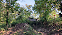
Blue-level trailbed with technical features that can come up quickly. Features include:
Steel I-beam skinnies, including one to a gap drop.
Small tabletops and gap jumps
Drops
Inexperienced users should walk or carefully ride trail before riding features at speed.
Note: Trail may take on water during heavy rainstorms due to proximity to Plaster Creek.

Access Info

Trail starts northwest of pumptrack at the west side of the parking area.

Local Trail Association
Traditionally Indigenous Territory

Recent Activity on Trail

Past Week
  • 0 rides
  •  
6 Months
  • 0 rides
  •  
All
  • 19 rides
  • Last: Jun 11, 2026
c1c2c3c4
January
February
March
April
May
June
July
August
September
October
November
December
update trails status or condition

GRBP Loop Trail Reports

statusdatedescription
Jun 28, 2025 @ 6:18pm
Jun 28, 2025
riding great, 1 small puddle between two jumps but other than that it was pretty ideal riding conditions
Apr 22, 2025 @ 6:13pm
Apr 22, 2025
reporter
WMMBA volunteer day! Earth Day litter clean up!
Apr 7, 2024 @ 10:14am
Apr 7, 2024
Fun little loop. Much shorter than I was expecting (just from the Youtube videos that focused on the few big features). But still a lot of fun -...
Jun 12, 2023 @ 8:34am
Jun 12, 2023
more »
Status:
on Jun 28, 2025
Variable
Avg: 4.24 (2 votes)
Your vote: 0

view (276)
close
3D
Trail Conditions
  • Unknown
  • Snow Groomed
  • Snow Packed
  • Snow Covered
  • Snow Cover Partial
  • Freeze/thaw Cycle
  • Icy
  • Prevalent Mud
  • Wet
  • Variable
  • Ideal
  • Dry
  • Very Dry
Trail Flow (Ridden Direction)
Trailforks scans users ridelogs to determine the most popular direction each trail is ridden. A good flowing trail network will have most trails flowing in a single direction according to their intension.
The colour categories are based on what percentage of riders are riding a trail in its intended direction.
  • > 96%
  • > 90%
  • > 80%
  • > 70%
  • > 50%
  • < 50%
  • bi-directional trail
  • no data
Trail Last Ridden
Trailforks scans ridelogs to determine the last time a trail was ridden.
  • < 2 days
  • < 1 week
  • < 2 weeks
  • < 1 month
  • < 6 months
  • > 6 months
Trail Ridden Direction
The intended direction a trail should be ridden.
  • Downhill Only
  • Downhill Primary
  • Both Directions
  • Uphill Primary
  • Uphill Only
  • One Direction
Contribute Details
Colors indicate trail is missing specified detail.
  • Description
  • Photos
  • Description & Photos
  • Videos
Trail Popularity ?
Trailforks scans ridelogs to determine which trails are ridden the most in the last 9 months. Trails are compared with nearby trails in the same city region with a possible 25 colour shades. Think of this as a heatmap, more rides = more kinetic energy = warmer colors.
  • most popular
  • popular
  • less popular
  • not popular
ATV/ORV/OHV Filter
Max Vehicle Width
inches
US Cell Coverage
Legend
cell carrier legend

Radar Time
Activity Recordings
Trailforks uses anonymized public activity data. ?
Activity Recordings
Trailforks uses anonymized public activity data. ?
Personal Heatmap
Activity Types
all / none
Options
2
Date range month
Winter Trails
Warning A routing network for winter maps does not exist. Selecting trails using the winter trails layer has been disabled.
Missing Trails
Most Popular
Least Popular
Trails are colored based on popularity. The more popular a trail is, the more red. Less popular trails trend towards green.
Jump Magnitude Heatmap
Heatmap of where riders jump on trails. Zoom in to see individual jumps, click circles to view jump details.
BC Backroad Status

Service Road Atlas is a free to use, community-driven service for viewing and creating reports on the numerous back-country service roads around B.C. and Alberta.

map legend
Slope Aspect
Direction the slope faces
Flat N NE E SE S SW W NW
Trails Deemphasized
Trails are shown in grey.
disable
Only show trails with no bike usage.
Enable
Suggested Layers
Based on selected activity type

    Save the current map location and zoom level as your default home location whenever this page is loaded.

    Save
        Directions to grbp-loop trailhead (42.923180, -85.679130)

        Photos

        10 more »
        186 |
        May 17, 2023 @ 8:36pm
        May 17, 2023
        206 |
        May 17, 2023 @ 8:36pm
        May 17, 2023
        131 |
        Mar 3, 2024 @ 6:22am
        Mar 3, 2024
        119 |
        Mar 3, 2024 @ 6:22am
        Mar 3, 2024

        Videos

        2 more »
        Beam drop
        0:16 | 93 | Nov 7, 2023 , Grand Rapids
        Beam drop
        0:16 | | Oct 18, 2023 , Grand Rapids

        Reviews / Comments

        No reviews yet, be the first to write a review or ask a question.
        Use trail reports to comment on trail conditions.


        We hope you've been enjoying Trailforks!

        Create a FREE account to view trail comments and much more.

        • By senorbaskuul & contributors
        • #607657 - 968 views

        Frequently Asked Questions About GRBP Loop

        Where is GRBP Loop located?
        GRBP Loop is located in Grand Rapids Bike Park, Grand Rapids, Michigan, United States. It is part of the Grand Rapids Bike Park trail network. The trailhead is located at coordinates 42.92318, -85.67913.
        How hard is GRBP Loop?
        GRBP Loop is rated as Blue difficulty. The average grade is 0.1%.
        What is the elevation gain for GRBP Loop?
        GRBP Loop has 14 ft of elevation gain. The trail has 9 ft of elevation descent. The elevation ranges from 628 ft to 639 ft.
        Is GRBP Loop a point to point trail?
        GRBP Loop is not a point to point trail. The direction is Both Directions. The trail type is singletrack.

        Hit the Trail

        Open in App

        Get this trail on your phone instantly.
        open trail in app

        Download Trail

        Save to wishlist, Garmin & download.
        save the trail

        Find Related Routes

        Find routes and users activities that include this trail.
        find routes for this trail

        You must enter a description before submitting.