more stats
1.5 miles
Distance
197 ft
Climb
-391 ft
Descent
00:13:42
Avg time
-194 ft
Altitude change
6,838 ft
Altitude min
7,197 ft
Altitude max
7,158 ft
Altitude start
6,965 ft
Altitude end
-2.5%
Grade
-52.3%
Grade max
46%
Grade min
3,307 ft
Distance climb
4,226 ft
Distance down
381 ft
Distance flat
00:13:42
Avg time

Grubstake Loop Details

  • Activities
    • Mountain Bike
    • Horse
    • Hike
    • Trail Running
  • Riding Area
    Apex Park
    Golden, Colorado
  • Difficulty Rating
  • Voted Difficulty
    Blue (2 votes)
  • Local Popularity
    70 in Mountain Biking [+]
    • 80 in Trail Running
    • 60 in Hiking
    • 5 in Horseback
  • Global Ranking
    #62687 in Mountain Biking [+]
    • #64057 in Trail Running
    • #93060 in Hiking
    • #3436 in Horseback
  • Trail Type
    Singletrack
  • Bike Type
    XC
  • Direction
    Both Directions
    Popular Direction Shown
  • Climb Difficulty
    Blue
  • Physical Rating
    Moderate
  • Dogs Allowed
    Yes
  • eBike Allowed

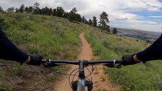
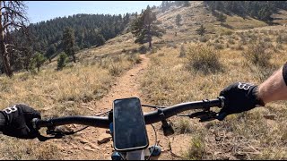
Fun outer loop. Starting from the west end, the trail drops downhill through a series of tight switchbacks. At the bottom, the trail climbs out of the woods and finishes with views of the Front Range. Take a right and loop back onto Bonanza or stay left and connect to Pick-n-Sledge.

Local Trail Association
Traditionally Indigenous Territory

Recent Activity on Trail

Past Week
  • 5 rides
  • 13 miles average
6 Months
  • 90 rides
  • 10 miles avg distance
All
  • 562 rides
  • Last: Jun 21, 2026
c1c2c3c4
January
February
March
April
May
June
July
August
September
October
November
December
update trails status or condition

Grubstake Loop Trail Reports

Status:
on Dec 26, 2025
Dry
Avg: 4.24 (6 votes)
Your vote: 0

view (5,658)
close
3D
Trail Conditions
  • Unknown
  • Snow Groomed
  • Snow Packed
  • Snow Covered
  • Snow Cover Partial
  • Freeze/thaw Cycle
  • Icy
  • Prevalent Mud
  • Wet
  • Variable
  • Ideal
  • Dry
  • Very Dry
Trail Flow (Ridden Direction)
Trailforks scans users ridelogs to determine the most popular direction each trail is ridden. A good flowing trail network will have most trails flowing in a single direction according to their intension.
The colour categories are based on what percentage of riders are riding a trail in its intended direction.
  • > 96%
  • > 90%
  • > 80%
  • > 70%
  • > 50%
  • < 50%
  • bi-directional trail
  • no data
Trail Last Ridden
Trailforks scans ridelogs to determine the last time a trail was ridden.
  • < 2 days
  • < 1 week
  • < 2 weeks
  • < 1 month
  • < 6 months
  • > 6 months
Trail Ridden Direction
The intended direction a trail should be ridden.
  • Downhill Only
  • Downhill Primary
  • Both Directions
  • Uphill Primary
  • Uphill Only
  • One Direction
Contribute Details
Colors indicate trail is missing specified detail.
  • Description
  • Photos
  • Description & Photos
  • Videos
Trail Popularity ?
Trailforks scans ridelogs to determine which trails are ridden the most in the last 9 months. Trails are compared with nearby trails in the same city region with a possible 25 colour shades. Think of this as a heatmap, more rides = more kinetic energy = warmer colors.
  • most popular
  • popular
  • less popular
  • not popular
ATV/ORV/OHV Filter
Max Vehicle Width
inches
US Cell Coverage
Legend
cell carrier legend

Radar Time
Activity Recordings
Trailforks uses anonymized public activity data. ?
Activity Recordings
Trailforks uses anonymized public activity data. ?
Personal Heatmap
Activity Types
all / none
Options
2
Date range month
Winter Trails
Warning A routing network for winter maps does not exist. Selecting trails using the winter trails layer has been disabled.
Missing Trails
Most Popular
Least Popular
Trails are colored based on popularity. The more popular a trail is, the more red. Less popular trails trend towards green.
Jump Magnitude Heatmap
Heatmap of where riders jump on trails. Zoom in to see individual jumps, click circles to view jump details.
BC Backroad Status

Service Road Atlas is a free to use, community-driven service for viewing and creating reports on the numerous back-country service roads around B.C. and Alberta.

map legend
Slope Aspect
Direction the slope faces
Flat N NE E SE S SW W NW
Trails Deemphasized
Trails are shown in grey.
disable
Only show trails with no bike usage.
Enable
Suggested Layers
Based on selected activity type

    Save the current map location and zoom level as your default home location whenever this page is loaded.

    Save
        Directions to grubstake-loop trailhead (39.717220, -105.229500)

        Photos

        19 more »
        59 |
        Mar 18, 2025 @ 11:29am
        Mar 18, 2025
        120 |
        Nov 30, 2023 @ 2:49pm
        Nov 30, 2023
        48 |
        Oct 11, 2023 @ 11:59am
        Oct 11, 2023
        54 |
        Oct 11, 2023 @ 11:57am
        Oct 11, 2023

        Videos

        5 more »
        youtuber Mountain Biking The Grubstake Loop and Pick N...
        14:19 | 665 | Jun 25, 2018 , Golden
        Golden, Co MTB 1/2 | Apex Park | Argos |...
        8:28 | 49 | Aug 3, 2025 , Golden
        Grubstake Loop (clockwise) - Apex - Golden -...
        7:00 | 105 | Oct 7, 2024 , Golden
        Grubstake Loop - Apex - Golden - Colorado
        0:35 | 189 | Aug 18, 2022 , Golden

        Routes with this trail

        8 miles 1,628 ft 9 Loop
        Technical climb followed by excellent downhill on enchanted forest and apex trail. Subject to direction...

        3 Reviews & Comments


        We hope you've been enjoying Trailforks!

        Create a FREE account to view trail comments and much more.

        • By toddTF Pro Trailforks & contributors
        • #13202 - 3,129 views

        Frequently Asked Questions About Grubstake Loop

        Where is Grubstake Loop located?
        Grubstake Loop is located in Apex Park, Golden, Colorado, United States. It is part of the Apex Park trail network. The trailhead is located at coordinates 39.71722, -105.2295.
        How hard is Grubstake Loop?
        Grubstake Loop is rated as Blue difficulty. The physical rating is Moderate. The average grade is 2.5%. The climb difficulty is rated Blue.
        What is the elevation gain for Grubstake Loop?
        Grubstake Loop has 197 ft of elevation gain. The trail has 391 ft of elevation descent. The elevation ranges from 6,838 ft to 7,197 ft.
        Is Grubstake Loop a point to point trail?
        Grubstake Loop is not a point to point trail. The direction is Both Directions. The trail type is singletrack.

        Hit the Trail

        Open in App

        Get this trail on your phone instantly.
        open trail in app

        Download Trail

        Save to wishlist, Garmin & download.
        save the trail

        Find Related Routes

        Find routes and users activities that include this trail.
        find routes for this trail

        You must enter a description before submitting.