Trail Supporters, Builders & Maintainers of Gunny Loop Trail
Grand Valley Trails AllianceSponsor
Singletrack TrailsBuilder
BLMLand Manager
Gunny Loop Details
-
Activities
- Mountain Bike
- Hike
- Trail Running
-
Riding AreaLunch Loops
Grand Junction, Colorado -
Difficulty Rating
-
Voted DifficultyBlue (1 vote)
-
Trail TypeSingletrack
-
Bike TypeAM, XC
-
Trail UsageBiking Primary
-
DirectionDownhill PrimaryPopular direction shown
-
Climb DifficultyBlue
-
Physical RatingModerate
-
Dogs AllowedYes
-
eBike Allowed
-
TTFs on TrailJump, Rock Face, Rock Garden
-
Global Ranking
-
Local Popularity85 in Mountain Biking [+]
- 45 in Trail Running
- 60 in Hiking
-
Land ManagerGrand Junction Field Office of the BLM
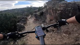
Gunny Loop is divided into two sections on Trail Forks, but it it seldom ridden as only half. The first section, this section, climbs up from Little Park Road to the height of Little Park Trailhead. The tread is a moderately technical, sustained climb with something going on at all times. There are a lot of rock features that sap momentum if you let them, but can be a fun, technical challenge if you embrace the nature of this trail. This section goes past the Gunnector intersection and keeps climbing to the right and eventually gains the height of the First Flats. It then traverses around through a fun, moderately chaotic section of straight-edged rocks finally arriving at the Gunny Cuttoff doubletrack and the end of this section. If you continue on, you enter what locals call the "stopper" section of the Gunny Loop, which on Trail Forks is referred to as Gunny Loop (East)
Access Info
The Gunny Loop can be accessed off of Little Park Road at the Bus Turnaround, off of the Andy's Loop Cutoff directly opposite the top of Andy's Loop, First Flats and the Little Park Road Trailhead, the Gunny Cutoff doubletrack, the "stopper section" of Gunny Loop.
Local Trail Association
-
Please consider joining or donating to the local trail association to supportdonate to earn trail karma!
trail development & maintenance.
Traditionally Indigenous Territory
More Stats for Gunny Loop mountain bike trail trail
-
Altitude change160 ft
-
Altitude min5,333 ft
-
Altitude max5,535 ft
-
Altitude start5,371 ft
-
Altitude end5,531 ft
-
Grade1.867%
-
Grade max-33.792%
-
Grade min48.217%
-
Distance climb4,705 ft
-
Distance down2,732 ft
-
Distance flat1,119 ft
-
Avg time00:14:53
-
Avg reverse time00:14:55
- view trail stats
- Unknown
- Snow Groomed
- Snow Packed
- Snow Covered
- Freeze/thaw Cycle
- Icy
- Prevalent Mud
- Wet
- Variable
- Ideal
- Dry
- Very Dry
The colour categories are based on what percentage of riders are riding a trail in its intended direction.
- > 96%
- > 90%
- > 80%
- > 70%
- > 50%
- < 50%
- < 2 days
- < 1 week
- < 2 weeks
- < 1 month
- < 6 months
- > 6 months
- Downhill Only
- Downhill Primary
- Both Directions
- Uphill Primary
- Uphill Only
- One Direction
- Description
- Photos
- Description & Photos
- Videos
- most popular
- popular
- less popular
- not popular
- Access Road/Trail
- White
- Green
- Blue
- Black
- Double Black Diamond
Trail Report Status
- Clear / Green
- Minor Issue / Yellow
- Significant Issue / Amber
- Closed
- Land Owner Overlay
- Wilderness (typically no bikes in USA)
- BLM (public)
- USFS (Wildlife sanctuaries darker than usfs)
- State land
- Indigenous
- Military
- Unknown
- Snow Groomed
- Snow Packed
- Snow Covered
- Freeze/thaw Cycle
- Icy
- Prevalent Mud
- Wet
- Variable
- Ideal
- Dry
- Very Dry
- Map Markers
Trail Head
Photo
Directory Listing
Riding Area
TTF
Parking
Viewpoint
Information
Warning
Directions
Sight
Restrooms
eBike Charging Point
Water Fountain/Source
Gate
Trail Sign
Table or Bench
Ladder
Stairs
Bridge
Boardwalk
Camping
Cabin
Lodge
Bear Cache
Dock
Ranger Station
Summit
Other
Gunny Loop Trail Reports
Recent Ridelog Activity on Trail
Past Week
- 23 rides
- 16 miles avg distance
6 Months
- 270 rides
- 15 miles avg distance
All
- 1,294 rides
Photos
Trail Lists
-
Bang's Canyon Hit List
10 trails
Routes with this trail
Reviews / Comments
No reviews yet, be the first to write a review or ask a question.
Use trail reports to comment on trail conditions.
Videos
Nearby Trails
- Eagle Wing 1,568 ft
- Andy's Loop Cuttoff 2,999 ft
- Pre Nup 3,520 ft
- Gunny Acc East 3,711 ft
- Gunny Acc West 3,711 ft
- embed Gunny Loop trail on your website
- By todd
Trailforks Plus & contributors
- #12143 - 5,027 views
- subscribe
- login to download gpx or kml files.