3.3 miles
Distance
59 ft
Climb
-1,854 ft
Descent
00:25:28
Avg time

Hacklberg Trail Details

  • Activities
    • Mountain Bike
    • E-Bike
  • Riding Area
    Bike-Circus - Saalbach Hinterglemm
    Saalbach Hinterglemm
  • Ref Number
    SH35
  • Difficulty Rating
  • Voted Difficulty
    Blue (16 votes)
  • Trail Type
    Singletrack
  • Bike Type
    AM, XC
  • Direction
    Downhill Primary
    Popular direction shown
  • Physical Rating
    Easy
  • Trail Visibility
    Always easy to follow
  • Dogs Allowed
    Yes
  • eBike Allowed
    Yes up to Class 1
  • TTFs on Trail
    Jump
  • Global Ranking
    #955 in Mountain Biking [+]
    • #1952 in E-Biking
  • Local Popularity
    100 in Mountain Biking [+]
    • 90 in E-Biking
  • Land Owner

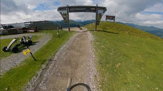
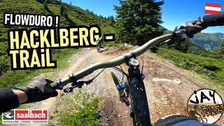
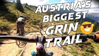
The Hacklberg Trail from the Schattberg in Saalbach over the Westgipfel summit to Hinterglemm is one of the most beautiful singletrails in the valley, and is known throughout Austria as the epitome of a flowing trail. But work comes before pleasure here, in the form of a demanding climb that has to be overcome before being able to enjoy the extra-long descent.

This natural, flowing trail begins right beside the top station of the Westgipfel lift, and heads off down towards the Hacklberg Alm along a grassy ridge. It offers plenty of opportunity for speed, as well as having some berms, smaller jumps, and numerous rollers providing you with plenty of opportunity for airtime. Thanks to its gentle gradient, beginners can enjoy it as well as experts.

Bike Park

More Stats for Hacklberg Trail mountain bike trail trail
  • Altitude change
    -1,795 ft
  • Altitude min
    5,046 ft
  • Altitude max
    6,841 ft
  • Altitude start
    6,841 ft
  • Altitude end
    5,046 ft
  • Grade
    -10.1%
  • Grade max
    -59.5%
  • Grade min
    19.1%
  • Distance climb
    1,457 ft
  • Distance down
    3 miles
  • Distance flat
    344 ft
  • Avg time
    00:25:28
  • Avg reverse time
    00:58:53
  • view trail stats
Status:
on Oct 1, 2023
Ideal
Avg: 4.8 (77 votes)
Your vote: 0

view (6,231)
close
3D
Trail Conditions
  • Unknown
  • Snow Groomed
  • Snow Packed
  • Snow Covered
  • Snow Cover Inadequate
  • Freeze/thaw Cycle
  • Icy
  • Prevalent Mud
  • Wet
  • Variable
  • Ideal
  • Dry
  • Very Dry
Trail Flow (Ridden Direction)
Trailforks scans users ridelogs to determine the most popular direction each trail is ridden. A good flowing trail network will have most trails flowing in a single direction according to their intension.
The colour categories are based on what percentage of riders are riding a trail in its intended direction.
  • > 96%
  • > 90%
  • > 80%
  • > 70%
  • > 50%
  • < 50%
  • bi-directional trail
  • no data
Trail Last Ridden
Trailforks scans ridelogs to determine the last time a trail was ridden.
  • < 2 days
  • < 1 week
  • < 2 weeks
  • < 1 month
  • < 6 months
  • > 6 months
Trail Ridden Direction
The intended direction a trail should be ridden.
  • Downhill Only
  • Downhill Primary
  • Both Directions
  • Uphill Primary
  • Uphill Only
  • One Direction
Contribute Details
Colors indicate trail is missing specified detail.
  • Description
  • Photos
  • Description & Photos
  • Videos
Trail Popularity ?
Trailforks scans ridelogs to determine which trails are ridden the most in the last 9 months. Trails are compared with nearby trails in the same city region with a possible 25 colour shades. Think of this as a heatmap, more rides = more kinetic energy = warmer colors.
  • most popular
  • popular
  • less popular
  • not popular
ATV/ORV/OHV Filter
Max Vehicle Width
inches

Radar Time
x Activity Recordings
Trailforks users anonymized public ridelogs from the past 6 months.
  • mountain biking recent
  • mountain biking (>6 month)
  • hiking (1 year)
  • moto (1 year)
Activity Recordings
Trailforks users anonymized public skilogs from the past 12 months.
  • Downhill Ski
  • Backcountry Ski
  • Nordic Ski
  • Snowmobile
Winter Trails
Warning A routing network for winter maps does not exist. Selecting trails using the winter trails layer has been disabled.
x Missing Trails
Most Popular
Least Popular
Trails are colored based on popularity. The more popular a trail is, the more red. Less popular trails trend towards green.
Jump Magnitude Heatmap
Heatmap of where riders jump on trails. Zoom in to see individual jumps, click circles to view jump details.
Trails Deemphasized
Trails are shown in grey.
disable
Only show trails with NO bikes.
enable

Save the current map location and zoom level as your default home location whenever this page is loaded.

Save
      Directions to hacklberg-trail trailhead (47.364660, 12.622620)
      update trails status or condition

      Hacklberg Trail Trail Reports

      Recent Ridelog Activity on Trail

      Past Week
      • 21 rides
      • 22 miles avg distance
      6 Months
      • 1,031 rides
      • 29 miles avg distance
      All
      • 4,063 rides
      • Last: Oct 4, 2023

      Photos

      more »
      11 |
      Aug 25, 2023 @ 7:37am
      Aug 25, 2023
      53 |
      Oct 25, 2022 @ 4:46am
      Oct 25, 2022
      48 |
      Aug 19, 2022 @ 9:22am
      Aug 19, 2022
      58 |
      Feb 7, 2022 @ 1:12pm
      Feb 7, 2022

      Trail Lists

      7 Reviews & Comments


      We hope you've been enjoying Trailforks!

      Create a FREE account to view trail comments and much more.

      Videos

      more »
      youtuber Hacklberg Trail 2015 - Saalbach-Hinterglemm -...
      11:58 | 289 | Sep 3, 2015 , Saalbach Hinterglemm
      youtuber Hacklberg Trail 2016 - Saalbach-Hinterglemm -...
      11:48 | 442 | May 29, 2020 , Saalbach Hinterglemm
      Saalbach Hinterglem Leogang trip 2023
      9:06 | 43 | Jul 24, 2023 , Saalbach Hinterglemm
      youtuber INSANE CRASH and SKETCHY Riding in the...
      18:54 | 116 | Aug 23, 2022 , Saalbach Hinterglemm
      • By brenthillier NSMBA TRAILFORKS & contributors
      • #5552 - 13,492 views
      • subscribe
      • flag
      • login to download gpx or kml files.