more stats
2,316 ft
Distance
9 ft
Climb
-93 ft
Descent
00:03:28
Avg time
-83 ft
Altitude change
79 ft
Altitude min
175 ft
Altitude max
166 ft
Altitude start
82 ft
Altitude end
-3.6%
Grade
-20.9%
Grade max
3.9%
Grade min
243 ft
Distance climb
1,043 ft
Distance down
1,014 ft
Distance flat
00:03:28
Avg time

Hey Bub Details

  • Activities
    • Mountain Bike
    • E-Bike
    • Hike
    • Trail Running
  • Riding Area
    Whiskey Run Trails
    Coos Bay, Oregon
  • Difficulty Rating
  • Local Popularity
    85 in Mountain Biking [+]
    • 70 in E-Biking
    • 80 in Trail Running
    • 60 in Hiking
  • Global Ranking
    #55839 in Mountain Biking [+]
    • #70674 in Trail Running
    • #87783 in Hiking
  • Trail Type
    Singletrack
  • Bike Type
    XC, DJ
  • Direction
    Downhill Only
    Popular Direction Shown
  • Physical Rating
    Hard
  • Dogs Allowed
    Yes
  • eBike Allowed
  • TTFs on Trail
    Berm, Jump, Roller Coaster
  • Year Opened
    2018
  • Land Owner
    Coos County Forest

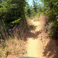
This is a one-way advanced flow trail with large berms, transfers, jumps, and optional ride lines. Choose your ride line carefully to gain the most speed and clear the transfers and jumps, while avoiding tight tress. Try to keep a high ride line and avoid the flats below the berms. Hey Bub is a fun descent on the Eastern side of The Snag section at Whiskey Run Trails with a short easy climb to get to the top. Make sure to exit at the end of the trail at the first (and only) left when you meet up with Hot Lap. Hot Lap traffic will be climbing, do not go straight down that one-way trail. Please respect the trail and only use when dry.

Access Info

This trail accessed from the top of The Snag. Please do not access this trail from the road.

Disclaimer

Pre-ride, re-ride, then rip.

Local Trail Association
Traditionally Indigenous Territory

Recent Activity on Trail

Past Week
  • 5 rides
  • 9 miles average
6 Months
  • 41 rides
  • 9 miles avg distance
All
  • 680 rides
  • Last: Jun 25, 2026
c1c2c3c4
January
February
March
April
May
June
July
August
September
October
November
December
update trails status or condition

Hey Bub Trail Reports

Status:
on Jun 14, 2026
Ideal
Avg: 4.39 (9 votes)
Your vote: 0

view (2,483)
close
3D
Trail Conditions
  • Unknown
  • Snow Groomed
  • Snow Packed
  • Snow Covered
  • Snow Cover Partial
  • Freeze/thaw Cycle
  • Icy
  • Prevalent Mud
  • Wet
  • Variable
  • Ideal
  • Dry
  • Very Dry
Trail Flow (Ridden Direction)
Trailforks scans users ridelogs to determine the most popular direction each trail is ridden. A good flowing trail network will have most trails flowing in a single direction according to their intension.
The colour categories are based on what percentage of riders are riding a trail in its intended direction.
  • > 96%
  • > 90%
  • > 80%
  • > 70%
  • > 50%
  • < 50%
  • bi-directional trail
  • no data
Trail Last Ridden
Trailforks scans ridelogs to determine the last time a trail was ridden.
  • < 2 days
  • < 1 week
  • < 2 weeks
  • < 1 month
  • < 6 months
  • > 6 months
Trail Ridden Direction
The intended direction a trail should be ridden.
  • Downhill Only
  • Downhill Primary
  • Both Directions
  • Uphill Primary
  • Uphill Only
  • One Direction
Contribute Details
Colors indicate trail is missing specified detail.
  • Description
  • Photos
  • Description & Photos
  • Videos
Trail Popularity ?
Trailforks scans ridelogs to determine which trails are ridden the most in the last 9 months. Trails are compared with nearby trails in the same city region with a possible 25 colour shades. Think of this as a heatmap, more rides = more kinetic energy = warmer colors.
  • most popular
  • popular
  • less popular
  • not popular
ATV/ORV/OHV Filter
Max Vehicle Width
inches
US Cell Coverage
Legend
cell carrier legend

Radar Time
Activity Recordings
Trailforks uses anonymized public activity data. ?
Activity Recordings
Trailforks uses anonymized public activity data. ?
Personal Heatmap
Activity Types
all / none
Options
2
Date range month
Winter Trails
Warning A routing network for winter maps does not exist. Selecting trails using the winter trails layer has been disabled.
Missing Trails
Most Popular
Least Popular
Trails are colored based on popularity. The more popular a trail is, the more red. Less popular trails trend towards green.
Jump Magnitude Heatmap
Heatmap of where riders jump on trails. Zoom in to see individual jumps, click circles to view jump details.
BC Backroad Status

Service Road Atlas is a free to use, community-driven service for viewing and creating reports on the numerous back-country service roads around B.C. and Alberta.

map legend
Slope Aspect
Direction the slope faces
Flat N NE E SE S SW W NW
Trails Deemphasized
Trails are shown in grey.
disable
Only show trails with no bike usage.
Enable
Suggested Layers
Based on selected activity type

    Save the current map location and zoom level as your default home location whenever this page is loaded.

    Save
        Directions to hey-bub trailhead (43.213130, -124.353920)

        Photos

        3 more »
        100 |
        Apr 25, 2020 @ 6:21pm
        Apr 25, 2020
        92 |
        Apr 25, 2020 @ 6:21pm
        Apr 25, 2020
        93 |
        Apr 25, 2020 @ 6:21pm
        Apr 25, 2020

        Videos

        1 more »
        Hey Bub July 2020
        0:00 | 341 | Aug 2, 2020 , Coos Bay

        Routes with this trail

        5.0 13 miles 1,495 ft 15 Loop
        Ready to put those climbing legs to work? This is a big looped (figure-8 style) route that can be...
        4.0 13 miles 1,754 ft 18 Loop
        Looking for a long day in the saddle? This route includes blues and greens with easy access back to the...
        5.0 16 miles 1,839 ft 45 Loop
        Coming out to Whiskey Run and want to sample some of the blue and green trails? This full day adventure...

        3 Reviews & Comments


        We hope you've been enjoying Trailforks!

        Create a FREE account to view trail comments and much more.

        • By whiskeyqueenTF Pro & contributors
        • #130706 - 1,739 views

        Frequently Asked Questions About Hey Bub

        Where is Hey Bub located?
        Hey Bub is located in Whiskey Run Trails, Coos Bay, Oregon, United States. It is part of the Whiskey Run Trails trail network. The trailhead is located at coordinates 43.21313, -124.35392.
        How hard is Hey Bub?
        Hey Bub is rated as Blue difficulty. The physical rating is Hard. The average grade is 3.6%.
        What is the elevation gain for Hey Bub?
        Hey Bub has 9 ft of elevation gain. The trail has 93 ft of elevation descent. The elevation ranges from 79 ft to 175 ft.
        Is Hey Bub a point to point trail?
        Yes, Hey Bub is a point to point trail. The direction is Downhill Only. The trail type is singletrack.

        Hit the Trail

        Open in App

        Get this trail on your phone instantly.
        open trail in app

        Download Trail

        Save to wishlist, Garmin & download.
        save the trail

        Find Related Routes

        Find routes and users activities that include this trail.
        find routes for this trail

        You must enter a description before submitting.