High Side Details
-
Activities
- Mountain Bike
- E-Bike
- Hike
- Trail Running
-
Riding AreaCheakamus
Whistler, British Columbia -
Difficulty Rating
-
Voted DifficultyBlack Diamond (3 votes)
-
Hiking SAC ScaleT2 Mountain Hiking
-
Trail TypeSingletrack
-
Bike TypeAM, XC
-
DirectionDownhill OnlyPopular direction shown
-
Physical RatingModerate
-
Trail VisibilityAlways easy to follow
-
Dogs AllowedYes
-
eBike Allowed
-
TTFs on TrailBerm, Rock Face
-
Ride in RainYes
-
Global Ranking
-
Local Popularity85 in Mountain Biking [+]
- 75 in E-Biking
- 65 in Trail Running
- 35 in Hiking
-
Year Opened2014
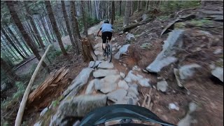
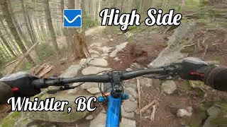
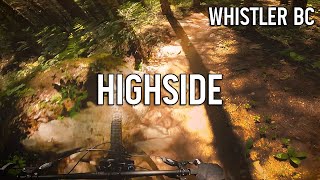
High Side is a fun, flowy descent connecting the bottom of See Colours and Puke towards the bottom of Highline/top of Farside. Predominately benchcut, but with a few natural bits, this trail will leave you with a smile on your face.
Bikes - downhill travel only please
Access Info
Best riding as the end of see colours and puke from the Lower Babylon connector, or climb Farside and Cheakamus Lake road to the Crater Rim lookout parking area and climb up See Colours and Puke for 10 minutes or so and look for High Side on the left.
Local Trail Association
-
Please consider joining or donating to the local trail association to supportdonate to earn trail karma!
trail development & maintenance.
Traditionally Indigenous Territory
More Stats for High Side mountain bike trail trail
-
Altitude change-338 ft
-
Altitude min2,484 ft
-
Altitude max2,823 ft
-
Altitude start2,821 ft
-
Altitude end2,484 ft
-
Grade-13.2%
-
Grade max-38.2%
-
Distance climb7 ft
-
Distance down2,264 ft
-
Distance flat167 ft
-
Avg time00:06:11
-
Avg reverse time00:16:41
- view trail stats
- Unknown
- Snow Groomed
- Snow Packed
- Snow Covered
- Snow Cover Partial
- Freeze/thaw Cycle
- Icy
- Prevalent Mud
- Wet
- Variable
- Ideal
- Dry
- Very Dry
The colour categories are based on what percentage of riders are riding a trail in its intended direction.
- > 96%
- > 90%
- > 80%
- > 70%
- > 50%
- < 50%
- bi-directional trail
- no data
- < 2 days
- < 1 week
- < 2 weeks
- < 1 month
- < 6 months
- > 6 months
- Downhill Only
- Downhill Primary
- Both Directions
- Uphill Primary
- Uphill Only
- One Direction
- Description
- Photos
- Description & Photos
- Videos
- most popular
- popular
- less popular
- not popular
- mountain biking recent
- mountain biking (>6 month)
- hiking (1 year)
- moto (1 year)
- Downhill Ski
- Backcountry Ski
- Nordic Ski
- Snowmobile
Save the current map location and zoom level as your default home location whenever this page is loaded.
SaveArticles
High Side Trail Reports
Recent Ridelog Activity on Trail
- 0 rides
- 91 rides
- 16.1 km avg distance
- 1,083 rides
- Last: Jan 3, 2025
Photos
Routes with this trail
Trail Products
-
WORCA Trail DonationTrail Pass
Pinkbike Articles
3 Reviews & Comments
We hope you've been enjoying Trailforks!
Create a FREE account to view trail comments and much more.
Nearby Trails
- Hihi 1,995 ft
- Hihi/high Side Access 2,264 ft
- Far Out 2 2,372 ft
- Flashback 2 2,395 ft
- Scap/high Side Access 2,736 ft
- By flipfantasia WORCA & contributors
- #7494 - 9,734 views
- follow/subscribe
- login to download gpx or kml files.
You must enter a description before submitting.