Supporters, Builders, Maintainers & Land Managers of Hillbender Trail
Teton Valley Trails and Pathways
since 2020Sponsor
Mountain Bike the Tetons
since 2020Builder
Hillbender Details
-
Activities
- Mountain Bike
- Horse
- Hike
- Trail Running
- Snowshoe
- Nordic Ski
-
Riding AreaSouthern Valley Trails / Mike Harris
Victor, Idaho -
Difficulty Rating
-
Trail TypeSingletrack
-
Snow GroomingGroomed Smooth
-
Bike TypeXC, Fat, Gravel
-
DirectionBoth DirectionsPopular in reverse
-
Climb DifficultyGreen
-
Physical RatingEasy
-
Trail VisibilityAlways easy to follow
-
SeasonMay - Nov
-
Family FriendlyYes
-
Dogs AllowedYes
-
eBike Allowed
-
Global Ranking
-
Local Popularity100 in Mountain Biking [+]
- 85 in Trail Running
- 95 in Hiking
- 5 in Horseback
- 100 in Snowshoeing
- 5 in Skiing
-
Year Opened2020
-
Land OwnerCaribou-Targhee National Forest, Teton Basin Ranger District
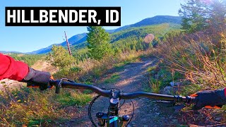
Brand new trail as of June 2020 that follows the hillside between the BPA road and the highway in the Southern Valley Trail System. Excellent, mellow climb to the top of Grumpy's and a super fun, flowy, bermed downhill. Best views from this part of the valley up Moose Creek and toward Teton Pass and Mt. OIiver.
Groomed for fatbikes and snowshoes.
Local Trail Association
-
Please consider joining or donating to the local trail association to supportdonate to earn trail karma!
trail development & maintenance.
Traditionally Indigenous Territory
More Stats for Hillbender mountain bike trail trail
-
Altitude change435 ft
-
Altitude min6,510 ft
-
Altitude max6,945 ft
-
Altitude start6,510 ft
-
Altitude end6,946 ft
-
Grade4.7%
-
Grade max-12.6%
-
Grade min42.9%
-
Distance climb1 mile
-
Distance down1,476 ft
-
Distance flat886 ft
-
Avg time00:17:47
-
Avg reverse time00:12:09
- view trail stats
- Unknown
- Snow Groomed
- Snow Packed
- Snow Covered
- Snow Cover Partial
- Freeze/thaw Cycle
- Icy
- Prevalent Mud
- Wet
- Variable
- Ideal
- Dry
- Very Dry
The colour categories are based on what percentage of riders are riding a trail in its intended direction.
- > 96%
- > 90%
- > 80%
- > 70%
- > 50%
- < 50%
- bi-directional trail
- no data
- < 2 days
- < 1 week
- < 2 weeks
- < 1 month
- < 6 months
- > 6 months
- Downhill Only
- Downhill Primary
- Both Directions
- Uphill Primary
- Uphill Only
- One Direction
- Description
- Photos
- Description & Photos
- Videos
- most popular
- popular
- less popular
- not popular
- mountain biking recent
- mountain biking (>6 month)
- hiking (1 year)
- moto (1 year)
- Downhill Ski
- Backcountry Ski
- Nordic Ski
- Snowmobile
Save the current map location and zoom level as your default home location whenever this page is loaded.
SaveHillbender Trail Reports
Recent Ridelog Activity on Trail
- 0 rides
- 83 rides
- 8 miles avg distance
- 407 rides
- Last: Feb 1, 2025
Photos
Routes with this trail
Reviews / Comments
No reviews yet, be the first to write a review or ask a question.
Use trail reports to comment on trail conditions.
We hope you've been enjoying Trailforks!
Create a FREE account to view trail comments and much more.
Nearby Trails
- Powerline Road 164 ft
- Happy Hour 390 ft
- Nemo 558 ft
- Rush Hour 1,634 ft
- Yeti's Loop 1,795 ft
Southern Valley Trails / Mike Harris
- By wygator
MBT & contributors
- #302483 - 2,876 views
- follow/subscribe
- login to download gpx or kml files.
You must enter a description before submitting.