more stats
2,982 ft
Distance
-418 ft
Descent
00:03:46
Avg time
-418 ft
Altitude change
4,214 ft
Altitude min
4,632 ft
Altitude max
4,632 ft
Altitude start
4,216 ft
Altitude end
-14%
Grade
-43.8%
Grade max
0.7%
Grade min
92 ft
Distance climb
2,743 ft
Distance down
151 ft
Distance flat
00:03:46
Avg time

Hoser Details

  • Activities
    • Mountain Bike
    • E-Bike
    • Hike
    • Trail Running
  • Riding Area
    Cypress Hills Provincial Park
    Elkwater, Alberta
  • Difficulty Rating
  • Local Popularity
    75 in Mountain Biking [+]
    • 5 in Trail Running
    • 5 in Hiking
  • Global Ranking
    #16030 in Mountain Biking [+]
    • #258999 in Trail Running
    • #295078 in Hiking
  • Trail Type
    Singletrack
  • Bike Type
    DH, AM, XC
  • Direction
    Downhill Only
    Popular Direction Shown
  • Physical Rating
    Hard
  • Trail Visibility
    Always easy to follow
  • Season
    May-October
  • Dogs Allowed
    Yes
  • eBike Allowed
  • TTFs on Trail
    Berm, Jump, Gap Jump
  • Year Opened
    2021
  • Land Owner

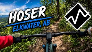
Hoser is a black technical trail that weaves it way down the T-bar line at the Hidden Valley resort. You can expect a mix of some technical features, flowy berms and watch for the out for the step-up near the bottom.

Access Info

Start where the T-bar line meets the Canadaina trail.

Local Trail Association

Recent Activity on Trail

Past Week
  • 0 rides
  •  
6 Months
  • 3 rides
  • 10 miles avg distance
All
  • 53 rides
  • Last: Jun 24, 2026
c1c2c3c4
January
February
March
April
May
June
July
August
September
October
November
December
Status:
on Jun 23, 2026
Variable
Avg: 4.24 (3 votes)
Your vote: 0

view (708)
close
3D
Trail Conditions
  • Unknown
  • Snow Groomed
  • Snow Packed
  • Snow Covered
  • Snow Cover Partial
  • Freeze/thaw Cycle
  • Icy
  • Prevalent Mud
  • Wet
  • Variable
  • Ideal
  • Dry
  • Very Dry
Trail Flow (Ridden Direction)
Trailforks scans users ridelogs to determine the most popular direction each trail is ridden. A good flowing trail network will have most trails flowing in a single direction according to their intension.
The colour categories are based on what percentage of riders are riding a trail in its intended direction.
  • > 96%
  • > 90%
  • > 80%
  • > 70%
  • > 50%
  • < 50%
  • bi-directional trail
  • no data
Trail Last Ridden
Trailforks scans ridelogs to determine the last time a trail was ridden.
  • < 2 days
  • < 1 week
  • < 2 weeks
  • < 1 month
  • < 6 months
  • > 6 months
Trail Ridden Direction
The intended direction a trail should be ridden.
  • Downhill Only
  • Downhill Primary
  • Both Directions
  • Uphill Primary
  • Uphill Only
  • One Direction
Contribute Details
Colors indicate trail is missing specified detail.
  • Description
  • Photos
  • Description & Photos
  • Videos
Trail Popularity ?
Trailforks scans ridelogs to determine which trails are ridden the most in the last 9 months. Trails are compared with nearby trails in the same city region with a possible 25 colour shades. Think of this as a heatmap, more rides = more kinetic energy = warmer colors.
  • most popular
  • popular
  • less popular
  • not popular
ATV/ORV/OHV Filter
Max Vehicle Width
inches
US Cell Coverage
Legend
cell carrier legend

Radar Time
Activity Recordings
Trailforks uses anonymized public activity data. ?
Activity Recordings
Trailforks uses anonymized public activity data. ?
Personal Heatmap
Activity Types
all / none
Options
2
Date range month
Winter Trails
Warning A routing network for winter maps does not exist. Selecting trails using the winter trails layer has been disabled.
Missing Trails
Most Popular
Least Popular
Trails are colored based on popularity. The more popular a trail is, the more red. Less popular trails trend towards green.
Jump Magnitude Heatmap
Heatmap of where riders jump on trails. Zoom in to see individual jumps, click circles to view jump details.
BC Backroad Status

Service Road Atlas is a free to use, community-driven service for viewing and creating reports on the numerous back-country service roads around B.C. and Alberta.

map legend
Slope Aspect
Direction the slope faces
Flat N NE E SE S SW W NW
Trails Deemphasized
Trails are shown in grey.
disable
Only show trails with no bike usage.
Enable
Suggested Layers
Based on selected activity type

    Save the current map location and zoom level as your default home location whenever this page is loaded.

    Save
        Directions to hoser trailhead (49.654040, -110.269910)

        Photos

        No photos have been added for Hoser yet, add a photo.

        Videos

        1 more »
        Hoser
        2:57 | 910 | Feb 12, 2022 , Elkwater

        Routes with this trail

        5.0 26 miles 4,576 ft 25 Race
        The Short Course is Stages 1, 2, 6, 7, 8.

        1 Review & Comments


        We hope you've been enjoying Trailforks!

        Create a FREE account to view trail comments and much more.

        • By CJD49TF Pro & contributors
        • #483370 - 914 views

        Frequently Asked Questions About Hoser

        Where is Hoser located?
        Hoser is located in Cypress Hills Provincial Park, Elkwater, Alberta, Canada. It is part of the Cypress Hills Provincial Park trail network. The trailhead is located at coordinates 49.65404, -110.26991.
        How hard is Hoser?
        Hoser is rated as Black Diamond difficulty. The physical rating is Hard. The average grade is 14%.
        What is the elevation gain for Hoser?
        The trail has 127 m of elevation descent. The elevation ranges from 1,284 m to 1,412 m.
        Is Hoser a point to point trail?
        Yes, Hoser is a point to point trail. The direction is Downhill Only. The trail type is singletrack.

        Hit the Trail

        Open in App

        Get this trail on your phone instantly.
        open trail in app

        Download Trail

        Save to wishlist, Garmin & download.
        save the trail

        Find Related Routes

        Find routes and users activities that include this trail.
        find routes for this trail

        You must enter a description before submitting.