2,825 ft
Distance
378 ft
Climb
-49 ft
Descent
00:13:48
Avg time

IMBY Details

  • Activities
    • Mountain Bike
    • Hike
    • Trail Running
  • Riding Area
    Eagle Mountain
    Coquitlam, British Columbia
  • Difficulty Rating
  • Voted Difficulty
    Black Diamond (2 votes)
  • Trail Type
    Singletrack
  • Bike Type
    AM, XC
  • Direction
    Uphill Primary
    Popular direction shown
  • Climb Difficulty
    Black Diamond
  • Physical Rating
    Hard
  • Dogs Allowed
    Yes
  • TTFs on Trail
    Bridge
  • Ride in Rain
    Yes
  • Global Ranking
    #1587 in Mountain Biking [+]
    • #1017 in Trail Running
    • #900 in Hiking
  • Local Popularity
    100 in Mountain Biking [+]
    • 100 in Trail Running
    • 100 in Hiking

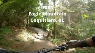
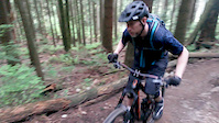
IMBY is a technical singletrack climbing only trail. It's narrow trail bed will test your technical climbing prowess. There are many tight switchbacks and very few recovery sections making it a challenging climb; the perfect place to perfect your climbing prowess.

IMBY links the lower backyard trails and Bert Flinn Park to the upper mountain via the gravel trail that starts at Aspenwood Elementary and connects to Fernway Drive.

Local Trail Association
More Stats for IMBY mountain bike trail trail
  • Altitude change
    329 ft
  • Altitude min
    1,077 ft
  • Altitude max
    1,410 ft
  • Altitude start
    1,077 ft
  • Altitude end
    1,407 ft
  • Grade
    11.657%
  • Grade max
    -18.42%
  • Grade min
    39.407%
  • Distance climb
    2,393 ft
  • Distance down
    330 ft
  • Distance flat
    102 ft
  • Avg time
    00:13:48
  • Avg reverse time
    00:13:07
  • view trail stats
Status:
on Jan 12, 2025
Variable
Avg: 3.96 (40 votes)
Your vote: 0

view (18,003)
close
3D
Trail Conditions
  • Unknown
  • Snow Groomed
  • Snow Packed
  • Snow Covered
  • Snow Cover Partial
  • Freeze/thaw Cycle
  • Icy
  • Prevalent Mud
  • Wet
  • Variable
  • Ideal
  • Dry
  • Very Dry
Trail Flow (Ridden Direction)
Trailforks scans users ridelogs to determine the most popular direction each trail is ridden. A good flowing trail network will have most trails flowing in a single direction according to their intension.
The colour categories are based on what percentage of riders are riding a trail in its intended direction.
  • > 96%
  • > 90%
  • > 80%
  • > 70%
  • > 50%
  • < 50%
  • bi-directional trail
  • no data
Trail Last Ridden
Trailforks scans ridelogs to determine the last time a trail was ridden.
  • < 2 days
  • < 1 week
  • < 2 weeks
  • < 1 month
  • < 6 months
  • > 6 months
Trail Ridden Direction
The intended direction a trail should be ridden.
  • Downhill Only
  • Downhill Primary
  • Both Directions
  • Uphill Primary
  • Uphill Only
  • One Direction
Contribute Details
Colors indicate trail is missing specified detail.
  • Description
  • Photos
  • Description & Photos
  • Videos
Trail Popularity ?
Trailforks scans ridelogs to determine which trails are ridden the most in the last 9 months. Trails are compared with nearby trails in the same city region with a possible 25 colour shades. Think of this as a heatmap, more rides = more kinetic energy = warmer colors.
  • most popular
  • popular
  • less popular
  • not popular
ATV/ORV/OHV Filter
Max Vehicle Width
inches
US Cell Coverage
Legend
cell carrier legend

Radar Time
x Activity Recordings
Trailforks users anonymized public ridelogs from the past 6 months.
  • mountain biking recent
  • mountain biking (>6 month)
  • hiking (1 year)
  • moto (1 year)
Activity Recordings
Trailforks users anonymized public skilogs from the past 12 months.
  • Downhill Ski
  • Backcountry Ski
  • Nordic Ski
  • Snowmobile
Winter Trails
Warning A routing network for winter maps does not exist. Selecting trails using the winter trails layer has been disabled.
x Missing Trails
Most Popular
Least Popular
Trails are colored based on popularity. The more popular a trail is, the more red. Less popular trails trend towards green.
Jump Magnitude Heatmap
Heatmap of where riders jump on trails. Zoom in to see individual jumps, click circles to view jump details.
Trails Deemphasized
Trails are shown in grey.
disable
Only show trails with NO bikes.
enable

Save the current map location and zoom level as your default home location whenever this page is loaded.

Save
      Directions to imby trailhead (49.307860, -122.828830)
      update trails status or condition

      IMBY Trail Reports

      statusdatedescription
      Jan 12, 2025 @ 10:24am
      Jan 12, 2025
      Dec 26, 2024 @ 2:14pm
      Dec 26, 2024
      reporter
      Trees cleared
      Dec 25, 2024 @ 2:38pm
      Dec 25, 2024
      Two trees down near the top of IMBY, both likely require a chainsaw.
      Dec 24, 2024 @ 1:34pm
      Dec 24, 2024
      Couple of trees down before the last switchback. One is quite large.
      Dec 21, 2024 @ 9:06am
      Dec 21, 2024
      view all reports »

      Recent Ridelog Activity on Trail

      Past Week
      • 10 rides
      • 7 miles avg distance
      6 Months
      • 282 rides
      • 7 miles avg distance
      All
      • 2,167 rides
      • Last: Jan 14, 2025

      Photos

      more »
      366 |
      Jul 23, 2016 @ 9:22pm
      Jul 23, 2016
      364 |
      Jul 12, 2015 @ 5:09pm
      Jul 12, 2015
      606 |
      Feb 15, 2015 @ 10:23am
      Feb 15, 2015
      120 |
      Feb 15, 2021 @ 5:24pm
      Feb 15, 2021

      Trail Lists

      Routes with this trail

      more »
      titledistance
      Extended Benefits - Eagle Mountain Climbing2 miles
      Eagle Mtn. Figure Eight6 miles
      Tri-Cities Triple Crown27 miles
      Lower Mountain loop4 miles

      7 Reviews & Comments


      We hope you've been enjoying Trailforks!

      Create a FREE account to view trail comments and much more.

      Videos

      more »
      IMBY (Climb) on Eagle Mountain, Coquitlam, BC
      10:31 | 180 | Oct 21, 2023 , Coquitlam
      IMBY - Eagle Mountain - Bike Trail
      9:37 | 1245 | Mar 17, 2018 , Coquitlam
      Skids or Skills?
      0:27 | 1132 | Nov 25, 2017 , Coquitlam
      IMBY
      3:12 | 1060 | May 24, 2015 , Coquitlam
      • By canadakaTF Pro Trailforks & contributors
      • #19770 - 13,735 views

      You must enter a description before submitting.