more stats
4,734 ft
Distance
-456 ft
Descent
00:06:50
Avg time
-456 ft
Altitude change
960 ft
Altitude min
1,416 ft
Altitude max
1,416 ft
Altitude start
961 ft
Altitude end
-9.6%
Grade
-49.9%
Grade max
4,675 ft
Distance down
59 ft
Distance flat
00:06:50
Avg time

Indécise Details

  • Activities
    • Mountain Bike
    • E-Bike
    • Adaptive Bike
  • Riding Area
  • Ref Number
    #6
  • Difficulty Rating
  • Voted Difficulty
    Green (2 votes)
  • Local Popularity
    55 in Mountain Biking [+]
    • 90 in E-Biking
  • Global Ranking
    #17664 in Mountain Biking [+]
    • #14908 in E-Biking
  • Trail Type
    Singletrack
  • Bike Type
    DH, AM, Adaptive MTB
  • Direction
    Downhill Only
    Popular Direction Shown
  • Physical Rating
    Moderate
  • Season
    May - Oct
  • eBike Allowed
    Yes up to Class 1
  • TTFs on Trail
    Berm, Bridge

No community description for Indécise trail has been added yet!

AI Generated Description

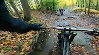
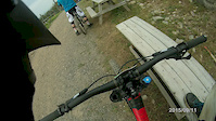
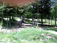
Indécise is a highly rated 1 km moderately popular green difficulty singletrack trail located near Bromont Quebec. This mountain bike primary trail can be used downhill only and has a moderate overall physical rating. It features berm and bridge. Adaptive MTB rating: amtb blue. On average it takes 6 minutes to complete this trail.

Access Info

Access by Bing Bang then you'll join the 21 (family trail) a little and look to your right to go back on the trail. Be careful since the trail cross the 21 a few times and people are not always looking out

Adaptive Bike Info
aMTB Blue Rating: Intermediate features and steeper terrain.

Bike Park

Traditionally Indigenous Territory

Recent Activity on Trail

Past Week
  • 2 rides
  • 12 miles average
6 Months
  • 17 rides
  • 13 miles avg distance
All
  • 259 rides
  • Last: Jun 30, 2026
c1c2c3c4
January
February
March
April
May
June
July
August
September
October
November
December
update trails status or condition

Indécise Trail Reports

statusdatedescription
Dec 7, 2025 @ 3:23am (America/Toronto)
Dec 7, 2025
Fermé pour la saison, on se revoit en 2026! / Closed for the season, see you all in 2026!
Jun 6, 2025 @ 5:08pm
Jun 6, 2025
May 27, 2025 @ 4:42am
May 27, 2025
Nov 7, 2024 @ 11:53pm
Nov 7, 2024
reporter Fermée pour la saison
Nov 7, 2024 @ 11:43pm
Nov 7, 2024
reporter Fermée pour la saison
more »
Status:
on Dec 7, 2025
Avg: 4.13 (17 votes)
Your vote: 0

view (2,204)
close
3D
Trail Conditions
  • Unknown
  • Snow Groomed
  • Snow Packed
  • Snow Covered
  • Snow Cover Partial
  • Freeze/thaw Cycle
  • Icy
  • Prevalent Mud
  • Wet
  • Variable
  • Ideal
  • Dry
  • Very Dry
Trail Flow (Ridden Direction)
Trailforks scans users ridelogs to determine the most popular direction each trail is ridden. A good flowing trail network will have most trails flowing in a single direction according to their intension.
The colour categories are based on what percentage of riders are riding a trail in its intended direction.
  • > 96%
  • > 90%
  • > 80%
  • > 70%
  • > 50%
  • < 50%
  • bi-directional trail
  • no data
Trail Last Ridden
Trailforks scans ridelogs to determine the last time a trail was ridden.
  • < 2 days
  • < 1 week
  • < 2 weeks
  • < 1 month
  • < 6 months
  • > 6 months
Trail Ridden Direction
The intended direction a trail should be ridden.
  • Downhill Only
  • Downhill Primary
  • Both Directions
  • Uphill Primary
  • Uphill Only
  • One Direction
Contribute Details
Colors indicate trail is missing specified detail.
  • Description
  • Photos
  • Description & Photos
  • Videos
Trail Popularity ?
Trailforks scans ridelogs to determine which trails are ridden the most in the last 9 months. Trails are compared with nearby trails in the same city region with a possible 25 colour shades. Think of this as a heatmap, more rides = more kinetic energy = warmer colors.
  • most popular
  • popular
  • less popular
  • not popular
ATV/ORV/OHV Filter
Max Vehicle Width
inches
US Cell Coverage
Legend
cell carrier legend

Radar Time
Activity Recordings
Trailforks uses anonymized public activity data. ?
Activity Recordings
Trailforks uses anonymized public activity data. ?
Personal Heatmap
Activity Types
all / none
Options
2
Date range month
Winter Trails
Warning A routing network for winter maps does not exist. Selecting trails using the winter trails layer has been disabled.
Missing Trails
Most Popular
Least Popular
Trails are colored based on popularity. The more popular a trail is, the more red. Less popular trails trend towards green.
Jump Magnitude Heatmap
Heatmap of where riders jump on trails. Zoom in to see individual jumps, click circles to view jump details.
BC Backroad Status

Service Road Atlas is a free to use, community-driven service for viewing and creating reports on the numerous back-country service roads around B.C. and Alberta.

map legend
Slope Aspect
Direction the slope faces
Flat N NE E SE S SW W NW
Trails Deemphasized
Trails are shown in grey.
disable
Only show trails with no bike usage.
Enable
Suggested Layers
Based on selected activity type

    Save the current map location and zoom level as your default home location whenever this page is loaded.

    Save
        Directions to indecise trailhead (45.290910, -72.642350)

        Photos

        2 more »
        389 |
        Apr 29, 2014 @ 10:02am
        Apr 29, 2014
        110 |
        Nov 9, 2020 @ 12:44pm
        Nov 9, 2020

        Videos

        5 more »
        La Fête à Bob | MTB Bromont
        14:38 | 114 | Nov 20, 2023 , Bromont
        trail 6
        3:02 | 61 | Oct 16, 2022 , Bromont
        bromont 6
        9:01 | 412 | Feb 19, 2016 , Bromont
        Bromont
        0:06 | 144 | Jul 31, 2011 , Bromont

        Trail Lists

        Routes with this trail

        10 miles 2,658 ft 30
        mini enduro ride at Bromont with easier options all single black decents
        10 miles 2,489 ft 28
        Some climbing but well worth it for the downs that you are rewarded
        2.7 14 miles 3,245 ft 29 Point to Point Race
        SCHEDULE SATURDAY JULY 8 2017 REGISTRATIONS: 9:30AM - 1:00PM : Registration open for all (plates pick up)...

        2 Reviews & Comments


        We hope you've been enjoying Trailforks!

        Create a FREE account to view trail comments and much more.

        • By Mavrey & contributors
        • #7333 - 3,061 views

        Frequently Asked Questions About Indécise

        Where is Indécise located?
        Indécise is located in Bromont: Montagne d'Expériences, Bromont, Quebec, Canada. It is part of the Bromont: Montagne d'Expériences trail network. The trailhead is located at coordinates 45.29091, -72.64235.
        How hard is Indécise?
        Indécise is rated as Green difficulty. The physical rating is Moderate. The average grade is 9.6%.
        What is the elevation gain for Indécise?
        The trail has 456 ft of elevation descent. The elevation ranges from 960 ft to 1,416 ft.
        Is Indécise a point to point trail?
        Yes, Indécise is a point to point trail. The direction is Downhill Only. The trail type is singletrack.

        Hit the Trail

        Open in App

        Get this trail on your phone instantly.
        open trail in app

        Download Trail

        Save to wishlist, Garmin & download.
        save the trail

        Find Related Routes

        Find routes and users activities that include this trail.
        find routes for this trail

        You must enter a description before submitting.