1.1 miles
Distance
50 ft
Climb
-34 ft
Descent
00:06:33
Avg time
Inner Log Loops Details
-
Activities
- Mountain Bike
- E-Bike
- Hike
- Trail Running
-
Riding AreaWalnut Creek Metropolitan Park
Austin, Texas -
Difficulty Rating
-
Voted DifficultyGreen (1 vote)
-
Trail TypeSingletrack
-
Bike TypeAM, XC
-
DirectionDownhill PrimaryPopular direction shown
-
Climb DifficultyGreen
-
Physical RatingEasy
-
Trail VisibilityAlways easy to follow
-
eBike Allowed
-
TTFs on TrailBerm
-
Global Ranking
-
Local Popularity100 in Mountain Biking [+]
- 100 in E-Biking
- 85 in Trail Running
- 95 in Hiking
-
Land OwnerCity of Austin
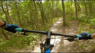
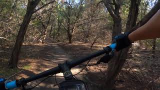
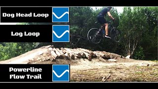
The inner part of the log loops trail is a nicely "bermed" easy to ride, well-packed dirt trail. It is great for a face-paced ride with lots of turns and very good cover from a hot Sun. The outer part has a few more rocks but is still mostly well-packed dirt.
You will find 2 spots with a fun jump (one on the outer and a double-jump on the inner).
Local Trail Association
-
Please consider joining or donating to the local trail association to supportdonate to earn trail karma!
trail development & maintenance.
Traditionally Indigenous Territory
More Stats for Inner Log Loops multi-use trail trail
-
Altitude change16 ft
-
Altitude min656 ft
-
Altitude max683 ft
-
Altitude start666 ft
-
Altitude end682 ft
-
Grade0.3%
-
Grade max-7.2%
-
Grade min6.6%
-
Distance climb2,044 ft
-
Distance down1,378 ft
-
Distance flat2,441 ft
-
Avg time00:06:33
-
Avg reverse time00:09:42
- view trail stats
close
3D
Trail Conditions
- Unknown
- Snow Groomed
- Snow Packed
- Snow Covered
- Snow Cover Partial
- Freeze/thaw Cycle
- Icy
- Prevalent Mud
- Wet
- Variable
- Ideal
- Dry
- Very Dry
Trail Flow (Ridden Direction)
Trailforks scans users ridelogs to determine the most popular direction each trail is ridden. A good flowing trail network will have most trails flowing in a single direction according to their intension.
The colour categories are based on what percentage of riders are riding a trail in its intended direction.
- > 96%
- > 90%
- > 80%
- > 70%
- > 50%
- < 50%
- bi-directional trail
- no data
Trail Last Ridden
Trailforks scans ridelogs to determine the last time a trail was ridden.
- < 2 days
- < 1 week
- < 2 weeks
- < 1 month
- < 6 months
- > 6 months
Trail Ridden Direction
The intended direction a trail should be ridden.
- Downhill Only
- Downhill Primary
- Both Directions
- Uphill Primary
- Uphill Only
- One Direction
Contribute Details
Colors indicate trail is missing specified detail.
- Description
- Photos
- Description & Photos
- Videos
Trail Popularity ?
Trailforks scans ridelogs to determine which trails are ridden the most in the last 9 months.
Trails are compared with nearby trails in the same city region with a possible 25 colour shades.
Think of this as a heatmap, more rides = more kinetic energy = warmer colors.
- most popular
- popular
- less popular
- not popular
ATV/ORV/OHV Filter
Max Vehicle Width
inches
US Cell Coverage
Legend
Radar Time
x
Activity Recordings
Trailforks users anonymized public ridelogs from the past 6 months.
- mountain biking recent
- mountain biking (>6 month)
- hiking (1 year)
- moto (1 year)
Activity Recordings
Trailforks users anonymized public skilogs from the past 12 months.
- Downhill Ski
- Backcountry Ski
- Nordic Ski
- Snowmobile
Winter Trails
Warning
A routing network for winter maps does not exist. Selecting trails using the winter trails layer has been disabled.
x
Missing Trails
Most Popular
Least Popular
Trails are colored based on popularity. The more popular a trail is, the more red. Less popular trails trend towards green.
Jump Magnitude Heatmap
Heatmap of where riders jump on trails. Zoom in to see individual jumps, click circles to view jump details.
Trails Deemphasized
Trails are shown in grey.
Only show trails with NO bikes.
Save the current map location and zoom level as your default home location whenever this page is loaded.
Save
Directions to inner-log-loops trailhead
(30.400120, -97.691040)
update trails status or condition
Inner Log Loops Trail Reports
view all reports »
Recent Ridelog Activity on Trail
Past Week
- 5 rides
- 12 miles avg distance
6 Months
- 421 rides
- 11 miles avg distance
All
- 2,455 rides
- Last: Jan 13, 2025
Photos
no photos have been added for Inner Log Loops yet, add a photo.
Trail Lists
-
Walnut Creek Reporting31 trails
Routes with this trail
more »
We hope you've been enjoying Trailforks!
Create a FREE account to view trail comments and much more.
Nearby Trails
- Ski Hill Flow Trail 285 ft
- Waterfall Crossing 285 ft
- Detention Dam Trail 558 ft
- Detention Dam Trail 587 ft
Walnut Creek Metropolitan Park
- By markholloway Trailforks Map Team & contributors
- #52684 - 4,546 views
- follow/subscribe
- login to download gpx or kml files.
You must enter a description before submitting.