more stats
2,566 ft
Distance
-1,005 ft
Descent
00:13:51
Avg time
-1,005 ft
Altitude change
2,645 ft
Altitude min
3,650 ft
Altitude max
3,650 ft
Altitude start
2,644 ft
Altitude end
-39.2%
Grade
-103.5%
Grade max
-7.3%
Grade min
2,566 ft
Distance down
00:13:51
Avg time

Jaws Details

  • Activities
    • Mountain Bike
    • E-Bike
    • Hike
    • Trail Running
    • Observed Trials
  • Riding Area
    Westside - Rainbow
    Whistler, British Columbia
  • Difficulty Rating
  • Voted Difficulty
    Double Black Diamond (1 vote)
  • Local Popularity
    35 in Mountain Biking [+]
    • 35 in E-Biking
    • 40 in Trail Running
    • 30 in Hiking
    • 5 in Observed Trials
  • Global Ranking
    #94215 in Mountain Biking [+]
    • #92297 in E-Biking
    • #121062 in Trail Running
    • #115122 in Hiking
    • #177 in Observed Trials
  • Trail Type
    Singletrack
  • Bike Type
    DH, AM
  • Direction
    Downhill Primary
    Popular Direction Shown
  • Physical Rating
    Extreme
  • Season
    May-November
  • Dogs Allowed
    Yes
  • eBike Allowed
    Yes up to Class 1
  • TTFs on Trail
    Rock Face

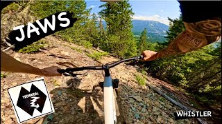
Steep, classic, chundery Whistler gnar. Loose, STEEP, and rocky chutes. Tons of fun, gets your brakes red hot. Be careful of trials riders coming up - they access the alpine here.

This trail is unsanctioned.

Recent Activity on Trail

Past Week
  • 0 rides
  •  
6 Months
  • 1 rides
  • 23.2 km avg distance
All
  • 69 rides
  • Last: May 15, 2026
c1c2c3c4
January
February
March
April
May
June
July
August
September
October
November
December
update trails status or condition

Jaws Trail Reports

statusdatedescription
Sep 11, 2025 @ 11:03am
Sep 11, 2025
Has a pretty big water rut through most of the trail, but still mostly rideable. I'm not sure what standard conditions are though.
Aug 14, 2024 @ 6:12pm
Aug 14, 2024
Jun 25, 2024 @ 4:52pm
Jun 25, 2024
reporter Steep, loose, chunked, and rowdy as h-e-double-hockey-sticks from top to bottom. What more could you ask for??? Ok, maybe it'd be nice to have...
Oct 1, 2023 @ 10:56am
Oct 1, 2023
Closed for 1 month due to cougar activity as per RMOW on behalf of COS
Aug 7, 2023 @ 9:29pm
Aug 7, 2023
Have you ever though to yourself "I like Howler, but I want something that gives me even more grip fatigue from braking, has much sharper and...
more »
Status:
on Sep 11, 2025
Avg: 4.17 (17 votes)
Your vote: 0

view (792)
close
3D
Trail Conditions
  • Unknown
  • Snow Groomed
  • Snow Packed
  • Snow Covered
  • Snow Cover Partial
  • Freeze/thaw Cycle
  • Icy
  • Prevalent Mud
  • Wet
  • Variable
  • Ideal
  • Dry
  • Very Dry
Trail Flow (Ridden Direction)
Trailforks scans users ridelogs to determine the most popular direction each trail is ridden. A good flowing trail network will have most trails flowing in a single direction according to their intension.
The colour categories are based on what percentage of riders are riding a trail in its intended direction.
  • > 96%
  • > 90%
  • > 80%
  • > 70%
  • > 50%
  • < 50%
  • bi-directional trail
  • no data
Trail Last Ridden
Trailforks scans ridelogs to determine the last time a trail was ridden.
  • < 2 days
  • < 1 week
  • < 2 weeks
  • < 1 month
  • < 6 months
  • > 6 months
Trail Ridden Direction
The intended direction a trail should be ridden.
  • Downhill Only
  • Downhill Primary
  • Both Directions
  • Uphill Primary
  • Uphill Only
  • One Direction
Contribute Details
Colors indicate trail is missing specified detail.
  • Description
  • Photos
  • Description & Photos
  • Videos
Trail Popularity ?
Trailforks scans ridelogs to determine which trails are ridden the most in the last 9 months. Trails are compared with nearby trails in the same city region with a possible 25 colour shades. Think of this as a heatmap, more rides = more kinetic energy = warmer colors.
  • most popular
  • popular
  • less popular
  • not popular
ATV/ORV/OHV Filter
Max Vehicle Width
inches
US Cell Coverage
Legend
cell carrier legend

Radar Time
Activity Recordings
Trailforks uses anonymized public activity data. ?
Activity Recordings
Trailforks uses anonymized public activity data. ?
Personal Heatmap
Activity Types
all / none
Options
2
Date range month
Winter Trails
Warning A routing network for winter maps does not exist. Selecting trails using the winter trails layer has been disabled.
Missing Trails
Most Popular
Least Popular
Trails are colored based on popularity. The more popular a trail is, the more red. Less popular trails trend towards green.
Jump Magnitude Heatmap
Heatmap of where riders jump on trails. Zoom in to see individual jumps, click circles to view jump details.
BC Backroad Status

Service Road Atlas is a free to use, community-driven service for viewing and creating reports on the numerous back-country service roads around B.C. and Alberta.

map legend
Slope Aspect
Direction the slope faces
Flat N NE E SE S SW W NW
Trails Deemphasized
Trails are shown in grey.
disable
Only show trails with no bike usage.
Enable
Suggested Layers
Based on selected activity type

    Save the current map location and zoom level as your default home location whenever this page is loaded.

    Save
        Directions to jaws trailhead (50.142080, -122.989820)

        Photos

        21 more »
        172 |
        Aug 26, 2020 @ 4:42pm
        Aug 26, 2020
        397 |
        Jul 1, 2018 @ 4:52pm
        Jul 1, 2018
        409 |
        Jul 17, 2017 @ 10:41pm
        Jul 17, 2017
        505 |
        Jul 17, 2017 @ 10:41pm
        Jul 17, 2017

        Videos

        8 more »
        youtuber JAWS | Double Black Trail | WHISTLER
        5:54 | 203 | Aug 1, 2024 , Whistler
        youtuber Not All of Us Survived... | EWS Whistler - Day 2
        57:45 | 701 | Aug 19, 2019 , Whistler
        5 Epic Peaks in WHISTLER | 19 Hours of Riding...
        16:15 | 90 | Jul 30, 2024 , Whistler
        Geoff Gulevich Chases PBA Winner Flo...
        9:47 | 445 | Jan 6, 2022 , Whistler

        Trail Lists

        Routes with this trail

        11 miles 3,899 ft 7 Loop
        Rainbow's End from Alpine
        3,891 ft 24 ft 3
        Special downhill stage for the Back Forty. Winner gets a prize pack from OneUp Components.

        Trail Products

        6 Reviews & Comments


        We hope you've been enjoying Trailforks!

        Create a FREE account to view trail comments and much more.

        • #37944 - 10,578 views

        Frequently Asked Questions About Jaws

        Where is Jaws located?
        Jaws is located in Westside - Rainbow, Whistler, British Columbia, Canada. It is part of the Westside - Rainbow trail network. The trailhead is located at coordinates 50.14208, -122.98982.
        How hard is Jaws?
        Jaws is rated as Double Black Diamond difficulty. The physical rating is Extreme. The average grade is 39.2%.
        What is the elevation gain for Jaws?
        The trail has 306 m of elevation descent. The elevation ranges from 806 m to 1,113 m.
        Is Jaws a point to point trail?
        Jaws is not a point to point trail. The direction is Downhill Primary. The trail type is singletrack.

        Hit the Trail

        Open in App

        Get this trail on your phone instantly.
        open trail in app

        Download Trail

        Save to wishlist, Garmin & download.
        save the trail

        Find Related Routes

        Find routes and users activities that include this trail.
        find routes for this trail

        You must enter a description before submitting.