more stats
2,415 ft
Distance
28 ft
Climb
-17 ft
Descent
00:03:13
Avg time
9 ft
Altitude change
4,302 ft
Altitude min
4,323 ft
Altitude max
4,302 ft
Altitude start
4,311 ft
Altitude end
0.4%
Grade
-7.6%
Grade max
13.6%
Grade min
745 ft
Distance climb
833 ft
Distance down
837 ft
Distance flat
00:03:13
Avg time

JEM (Upper) Details

  • Activities
    • Mountain Bike
    • Adaptive Bike
    • Hike
    • Trail Running
  • Riding Area
    Hurricane Cliffs
    Hurricane, Utah
  • Difficulty Rating
  • Voted Difficulty
    Green (1 vote)
  • Local Popularity
    100 in Mountain Biking [+]
    • 80 in Trail Running
    • 90 in Hiking
  • Global Ranking
    #38786 in Mountain Biking [+]
    • #35519 in Trail Running
    • #37236 in Hiking
  • Trail Type
    Singletrack
  • Bike Type
    AM, XC, Adaptive MTB
  • Direction
    Downhill Only
    Popular Direction Shown
  • Climb Difficulty
    Green
  • Physical Rating
    Easy
  • Dogs Allowed
    Yes
  • eBike Allowed
  • Land Owner
    Bureau of Land Management

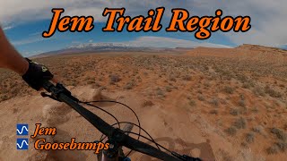
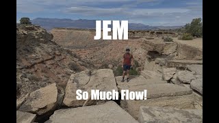
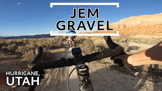
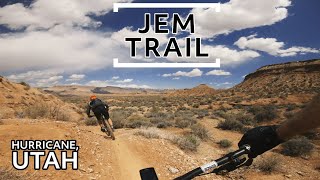
This the downhill only section JEM that starts off at the parking lot and takes you to the road. Smooth winding singletrack with some really interesting shale rock formations and mini-cliffs that you ride next to. This part can flow pretty fast if you keep on the gas, but is a really mellow trail, great for the kids. Remember no ebikes and Downhill only traffic.

Adaptive Bike Info
aMTB Blue Rating: Intermediate features and steeper terrain.

24 to 34 inches wide mostly on camber fun flowing downhill.

Trail Supporters
  • BLM
    BLM
    Land Manager
Local Trail Association
Traditionally Indigenous Territory

Recent Activity on Trail

Past Week
  • 7 rides
  • 8 miles average
6 Months
  • 291 rides
  • 21 miles avg distance
All
  • 2,231 rides
  • Last: Jun 26, 2026
c1c2c3c4
January
February
March
April
May
June
July
August
September
October
November
December
Status:
on Apr 20, 2026
Very Dry
Avg: 4.04 (20 votes)
Your vote: 0

view (11,631)
close
3D
Trail Conditions
  • Unknown
  • Snow Groomed
  • Snow Packed
  • Snow Covered
  • Snow Cover Partial
  • Freeze/thaw Cycle
  • Icy
  • Prevalent Mud
  • Wet
  • Variable
  • Ideal
  • Dry
  • Very Dry
Trail Flow (Ridden Direction)
Trailforks scans users ridelogs to determine the most popular direction each trail is ridden. A good flowing trail network will have most trails flowing in a single direction according to their intension.
The colour categories are based on what percentage of riders are riding a trail in its intended direction.
  • > 96%
  • > 90%
  • > 80%
  • > 70%
  • > 50%
  • < 50%
  • bi-directional trail
  • no data
Trail Last Ridden
Trailforks scans ridelogs to determine the last time a trail was ridden.
  • < 2 days
  • < 1 week
  • < 2 weeks
  • < 1 month
  • < 6 months
  • > 6 months
Trail Ridden Direction
The intended direction a trail should be ridden.
  • Downhill Only
  • Downhill Primary
  • Both Directions
  • Uphill Primary
  • Uphill Only
  • One Direction
Contribute Details
Colors indicate trail is missing specified detail.
  • Description
  • Photos
  • Description & Photos
  • Videos
Trail Popularity ?
Trailforks scans ridelogs to determine which trails are ridden the most in the last 9 months. Trails are compared with nearby trails in the same city region with a possible 25 colour shades. Think of this as a heatmap, more rides = more kinetic energy = warmer colors.
  • most popular
  • popular
  • less popular
  • not popular
ATV/ORV/OHV Filter
Max Vehicle Width
inches
US Cell Coverage
Legend
cell carrier legend

Radar Time
Activity Recordings
Trailforks uses anonymized public activity data. ?
Activity Recordings
Trailforks uses anonymized public activity data. ?
Personal Heatmap
Activity Types
all / none
Options
2
Date range month
Winter Trails
Warning A routing network for winter maps does not exist. Selecting trails using the winter trails layer has been disabled.
Missing Trails
Most Popular
Least Popular
Trails are colored based on popularity. The more popular a trail is, the more red. Less popular trails trend towards green.
Jump Magnitude Heatmap
Heatmap of where riders jump on trails. Zoom in to see individual jumps, click circles to view jump details.
BC Backroad Status

Service Road Atlas is a free to use, community-driven service for viewing and creating reports on the numerous back-country service roads around B.C. and Alberta.

map legend
Slope Aspect
Direction the slope faces
Flat N NE E SE S SW W NW
Trails Deemphasized
Trails are shown in grey.
disable
Only show trails with no bike usage.
Enable
Suggested Layers
Based on selected activity type

    Save the current map location and zoom level as your default home location whenever this page is loaded.

    Save
        Directions to jem-upper trailhead (37.139290, -113.241950)

        Photos

        7 more »
        123 |
        Oct 5, 2020 @ 9:21pm
        Oct 5, 2020
        118 |
        May 8, 2018 @ 9:27pm
        May 8, 2018
        50 |
        Apr 14, 2022 @ 5:50pm
        Apr 14, 2022
        92 |
        Jun 28, 2020 @ 4:02pm
        Jun 28, 2020

        Videos

        4 more »
        youtuber Jem and Goosebumps
        12:14 | 92 | Jul 8, 2025 , Hurricane
        JEM Mountain Bike Trail | Hurricane, UT
        3:56 | 206 | Oct 24, 2021 , Hurricane
        Golden hour, gravel bike
        4:16 | 253 | Aug 28, 2020 , Hurricane
        JEM Trail - Hurricane, Utah
        6:07 | 237 | Aug 28, 2020 , Hurricane

        Trail Lists

        Routes with this trail

        5.0 11 miles 775 ft 5 Loop
        Starting at the road where first crosses, ride southeast on and climb to the top of the mesa and hook a...
        3.0 24 miles 2,223 ft 8
        This is a big loop! There are lots of punchy ups and some steady climbs, so don't think that it's a mellow...
        5.0 16 miles 1,322 ft 20
        This is our planned medium length (~13 miles) loop in the Hurricane cliffs area. Hitting all of with an...

        2 Reviews & Comments


        We hope you've been enjoying Trailforks!

        Create a FREE account to view trail comments and much more.

        Nearby Trails

        • By toddTF Pro Trailforks & contributors
        • #118388 - 2,568 views

        Frequently Asked Questions About JEM (Upper)

        Where is JEM (Upper) located?
        JEM (Upper) is located in Hurricane Cliffs, Hurricane, Utah, United States. It is part of the Hurricane Cliffs trail network. The trailhead is located at coordinates 37.13929, -113.24195.
        How hard is JEM (Upper)?
        JEM (Upper) is rated as Green difficulty. The physical rating is Easy. The average grade is 0.4%. The climb difficulty is rated Green.
        What is the elevation gain for JEM (Upper)?
        JEM (Upper) has 28 ft of elevation gain. The trail has 17 ft of elevation descent. The elevation ranges from 4,302 ft to 4,323 ft.
        Is JEM (Upper) a point to point trail?
        Yes, JEM (Upper) is a point to point trail. The direction is Downhill Only. The trail type is singletrack.

        Hit the Trail

        Open in App

        Get this trail on your phone instantly.
        open trail in app

        Download Trail

        Save to wishlist, Garmin & download.
        save the trail

        Find Related Routes

        Find routes and users activities that include this trail.
        find routes for this trail

        You must enter a description before submitting.